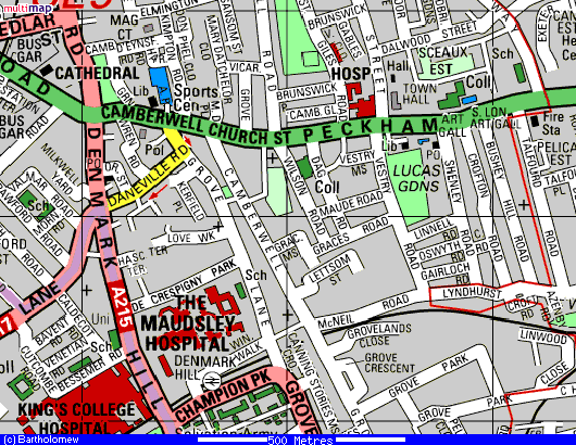
This map shows the area covered by the Wilson's Residents' Association. The Association is named after Wilson Road, but it also covers tenants and residents in: Dagmar Road, Maude Road, Grace's Road, Vestry Road and Grace's Mews. On the East we are bordered by Lucas Gardens and on the West by the Churchyard of St Giles Parish Church, which gives its name to the local council ward which we are in: St Giles. On the map you will also see Southwark Town Hall, on Peckham Road, Camberwell Library on Camberwell Church Street and Camberwell Leisure Centre at the end of Artichoke Place (marked 'Sports Centre'). The Library marked between the Town Hall and Lucas Gardens is actually the Registrar's Office for Births, Deaths and Marriages. The College on Wilson Road use to be the Wilson Grammar School for Boys, but is now part of the Camberwell School of Art and where the Foundation Year students study. Opposite the Wilson Annex (as it is known) is the Science and Technology Centre for Teachers.
Click here to view the map live Click here to return to the Home Page