Monday 8/21/00
Day 4: Monday 8/21 Cape Flattery, Hoh Rain Forest
 I
got up at 7:00 and got ready to leave. The first place I would go this morning
is on the road to Hurricane Ridge in the Olympic
National Forest. I knew I wouldn't get all the way there but would drive
as far as I could. I was only able to drive up to the entrance to the ranger
station as the rest of the road was closed. I did turn right just before the
park entrance and go up into a small parking lot. There was a trail there
that led to a Lake Dawn. There were houses on the other side of the lake that
had a good view of the Olympic mountains. This looked like a nice quiet place
to live in the snow during the winter and still be only ten miles away from
the ocean. I did get a good view of the mountains on the way back as it would
be another nice day today.
I
got up at 7:00 and got ready to leave. The first place I would go this morning
is on the road to Hurricane Ridge in the Olympic
National Forest. I knew I wouldn't get all the way there but would drive
as far as I could. I was only able to drive up to the entrance to the ranger
station as the rest of the road was closed. I did turn right just before the
park entrance and go up into a small parking lot. There was a trail there
that led to a Lake Dawn. There were houses on the other side of the lake that
had a good view of the Olympic mountains. This looked like a nice quiet place
to live in the snow during the winter and still be only ten miles away from
the ocean. I did get a good view of the mountains on the way back as it would
be another nice day today.
I drove back down to Port Angeles and took one more drive thru town. It's very touristy as there is a ferry boat the arrives and leaves for Victoria B.C. A good central location if you going to be staying here and visit the peninsula for a couple days. There are many hotels, restaurants and bars here along with two movie theatres. I went down the dock as there is a observatorythat overlooks the Straight and gives you a good view of Vancouver Island and the Olympics. I left town and started driving inland on 101 towards Lake Crescent. As I was driving towards Lake Crescent you could see where there has been a lot of forest cutting in the region. It's not as nice as I remember it years ago. Lake Crescent is a large lake with many houses built on the north side of the lake and highway 101 going along side the south side. I did stop at Barnes Point where there is camping but there was not much happening this time of year.
 I
finally reached the end of the lake and followed the Sol duc River until
meeting up with Highway 113. Turning right would take me to Ozette Lake
and Cape Flattery. About a mile after turning there was a small waterfall
with a lot of water coming over. I continued north and when I finally reached
the coast I would drive thru the small communities of Clallam Bay and Sekiu
Point. Both have hotels and stores for the weekend fisherman. Both seem
to be quiet communities and are the last major stopping point if you are
going to continue west. As I continued towards Neah Bay I couldn't help
but be disgusted with the amount of cutting that is going on. Trees were
being cut right up to houses back yards. Many old stumps were left and it
did not look like they are being replanted.
I
finally reached the end of the lake and followed the Sol duc River until
meeting up with Highway 113. Turning right would take me to Ozette Lake
and Cape Flattery. About a mile after turning there was a small waterfall
with a lot of water coming over. I continued north and when I finally reached
the coast I would drive thru the small communities of Clallam Bay and Sekiu
Point. Both have hotels and stores for the weekend fisherman. Both seem
to be quiet communities and are the last major stopping point if you are
going to continue west. As I continued towards Neah Bay I couldn't help
but be disgusted with the amount of cutting that is going on. Trees were
being cut right up to houses back yards. Many old stumps were left and it
did not look like they are being replanted.
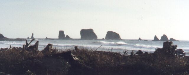
 The
beaches off of highway 112 are clean with nice views. There are many rock
formations arising out of the water. I stopped to take a couple pictures
before reaching Neah Bay. This is where the Indians from the Makah Indian
Reservation live. It was a friendly area and many people would wave as I
dove by. They were in the news last year when they were allowed to hunt
a whale off of the peninsula. There were many activists that protested in
boats and tried to scare the whales away. I drove thru the town and continued
on a paved road for about five more miles and came to a gravel road and
finally a parking lot. There is a half mile trail from here that leads to
Cape Flattery and had a great view on this clear sunny day. There was nobody
else here and is was relaxing to just sit out and look at the view of the
two large rocks protruding out from the ocean and the waves washing up against
them. There are also picnic tables here in the woods about a minute away
from the view.
The
beaches off of highway 112 are clean with nice views. There are many rock
formations arising out of the water. I stopped to take a couple pictures
before reaching Neah Bay. This is where the Indians from the Makah Indian
Reservation live. It was a friendly area and many people would wave as I
dove by. They were in the news last year when they were allowed to hunt
a whale off of the peninsula. There were many activists that protested in
boats and tried to scare the whales away. I drove thru the town and continued
on a paved road for about five more miles and came to a gravel road and
finally a parking lot. There is a half mile trail from here that leads to
Cape Flattery and had a great view on this clear sunny day. There was nobody
else here and is was relaxing to just sit out and look at the view of the
two large rocks protruding out from the ocean and the waves washing up against
them. There are also picnic tables here in the woods about a minute away
from the view.
 I drove back towards Neah bay and would drive down a gravel road to Hobuck
Beach. There are houses along here on the Indian reservation that have great
views of the ocean as it's a sandy beach. There is also a large fish hatchery
at the end of the road. There are many gravel roads that have closed gates
as I have been told that they have not been kept up and lots of trees are
laying over the roads. While I was done here there was a motor home that
tried to turn around and high centered his vehicle on a rock. He was going
to have to call a tow truck as there was nothing we could do for him. He
told us not to worry that he was going to take a nap while he waited. I
left here and started driving back on highway 112.
I drove back towards Neah bay and would drive down a gravel road to Hobuck
Beach. There are houses along here on the Indian reservation that have great
views of the ocean as it's a sandy beach. There is also a large fish hatchery
at the end of the road. There are many gravel roads that have closed gates
as I have been told that they have not been kept up and lots of trees are
laying over the roads. While I was done here there was a motor home that
tried to turn around and high centered his vehicle on a rock. He was going
to have to call a tow truck as there was nothing we could do for him. He
told us not to worry that he was going to take a nap while he waited. I
left here and started driving back on highway 112.
About halfway back on highhway 112 I would turn off on the Hiki-Ozette road for Lake Ozette. I have never been here but have heard that there are some great trails leading to the ocean from the lake. The road is in twenty miles and there is a lot of logging going on in this vicinity. There isn't much road access to the lake as it's only on the north end. I drove to the ranger station and received some information on the area. She said the two trails are each three miles long and lead to sandy beaches. She also recommended making reservations as this is a very busy park in the summer. They will only let 300 hikers at anytime on the trail and you have to register for hiking. You can also camp overnight as their are campsites along the beach. I will have to come back here some other time to hike to the beach for the day.
 Now I had to make a the long drive back to drive down to the town of Forks.
This would take about an hour of backtracking and finally got into town around
1:00. Right before getting to Forks
there is a turnoff to go to Risoto Beach and La Push. These are small fishing
communities where lots of hikers stay overnight. There are two small hikes
to Second Beach and Third Beach that are very popular here. Three are many
rock formations protruding from the water along these beaches. A good place
to spend a day exploring on a nice sunny day. I drove back to Forks, the only
actual town on the west side of the Olympic Peninsula. There is mainly logging
with some farming. A quiet town that celebrates logging days for a weekend
in the summer. I didn't stay long as I wanted to get to Aberdeen tonight and
still had places to see.
Now I had to make a the long drive back to drive down to the town of Forks.
This would take about an hour of backtracking and finally got into town around
1:00. Right before getting to Forks
there is a turnoff to go to Risoto Beach and La Push. These are small fishing
communities where lots of hikers stay overnight. There are two small hikes
to Second Beach and Third Beach that are very popular here. Three are many
rock formations protruding from the water along these beaches. A good place
to spend a day exploring on a nice sunny day. I drove back to Forks, the only
actual town on the west side of the Olympic Peninsula. There is mainly logging
with some farming. A quiet town that celebrates logging days for a weekend
in the summer. I didn't stay long as I wanted to get to Aberdeen tonight and
still had places to see.
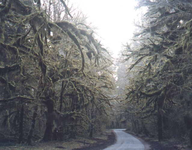
 Continuing
south I passed Bogachiel State Park which is the only state park on the east
side of the Olympics. It is located on the Bogachiel River and just south
of Forks. A couple miles south from here is the exit to the Hoh Rain Forest.
This is a good ride for scenery. As you drive near the Hoh River there is
good view of the Olympic at times. You drive thru very thick wooded area with
large growths of moss on the trees. It reminded me a little bit of the Queen
Charlotte Islands and their thick rain forests. I drove to the end by the
visitor center and there are may trails that one can take from here. It was
4:00 pm and almost dark as I left the visitor center. I drove back to Highway
101 reached Ruby Beach around 6:00 and took a couple pictures as the sun had
just gone down.
Continuing
south I passed Bogachiel State Park which is the only state park on the east
side of the Olympics. It is located on the Bogachiel River and just south
of Forks. A couple miles south from here is the exit to the Hoh Rain Forest.
This is a good ride for scenery. As you drive near the Hoh River there is
good view of the Olympic at times. You drive thru very thick wooded area with
large growths of moss on the trees. It reminded me a little bit of the Queen
Charlotte Islands and their thick rain forests. I drove to the end by the
visitor center and there are may trails that one can take from here. It was
4:00 pm and almost dark as I left the visitor center. I drove back to Highway
101 reached Ruby Beach around 6:00 and took a couple pictures as the sun had
just gone down.
I had plans of driving to Aberdeen tonight and staying there. I drove past several beaches for the next ten miles but it was too dark to see now. I'll have to come back here again. Quinault Lake is another ten miles inland from here and is one of the nicest lakes in the state. The Quinault Lodge is a good place to stay if you are looking for peace and quit while visiting the Olympic Peninsula. You can turn left at the lake and it will eventually take you onto gravel roads along the Quinault River and where there are many trails for good hiking. I have taken this road before and has good scenery with a relaxing quiet atmosphere as you drive along the river with the mountains in the background.
Last chapter, I promise. There wasn't much more to see as I entered the Aberdeen/Hoquium area around 7:00. My first thought was to stay here and go to a bar to listen to some grunge music. This is where Nirvana started out and I'm sure it's still played in local bars. I decided to get a good nights sleep though as we would be going to St Helens tomorrow and would be a busy day
I drove 400 miles today and 1000 total.