Tuesday 8/22/00
Day 5: Mt St Helens

 : I left this morning at 6:00am to go to St. Helens. It was going to be a
nice day in the 70's. I drove back on I-5 passing Olympia and at Tacoma I
turned south on highway 7. This was a busy highway with businesses and stop
lights thru South Tacoma, Parkway and Spanaway. I wanted to go this way to
get to Spirit Lake without taking I-5. After getting thru Tacoma you start
driving thru farming country with views of Mt Rainier. I stopped to take a
picture of Alder Lake which is a source for Tacoma electricity and has two
dams on it. This is a large reservoir where you can see many boats on the
weekends. My first stop would be at Elbe which is the intersection where you
can either go east to Mt Rainier or south to Mt St Helens. It is a small town
that is known for the railroad cars that are used for a restaurant and hotel
rooms. I looked inside the window of the cars, it looks like they would be
fun to stay in for a night.
: I left this morning at 6:00am to go to St. Helens. It was going to be a
nice day in the 70's. I drove back on I-5 passing Olympia and at Tacoma I
turned south on highway 7. This was a busy highway with businesses and stop
lights thru South Tacoma, Parkway and Spanaway. I wanted to go this way to
get to Spirit Lake without taking I-5. After getting thru Tacoma you start
driving thru farming country with views of Mt Rainier. I stopped to take a
picture of Alder Lake which is a source for Tacoma electricity and has two
dams on it. This is a large reservoir where you can see many boats on the
weekends. My first stop would be at Elbe which is the intersection where you
can either go east to Mt Rainier or south to Mt St Helens. It is a small town
that is known for the railroad cars that are used for a restaurant and hotel
rooms. I looked inside the window of the cars, it looks like they would be
fun to stay in for a night.
 I drove south from Elbe and would stop at the small town of Mineral Lake which had a great view of Mt. Rainier if you were on the lake with a boat. The houses on the lake all have waterfront views and block the view from the road. A quiet little community as many kids were riding their bike and locals were going into the small store. There were also many RV's parked near the boat launch area. Ten miles later I would reachteh town of Morton. This is a logging town and also have several restaurants, hotels and large stores to stock up if necessary. I was on highway 12 until reaching the small town of Randall where I would turn south on highway 131 past the Cowlitz River and then turn south on road 25. You also start climbing with hairpin curves and into a forested area. I stopped next at the Iron Creek Falls which is just a mile before the turn-off to Spirit Lake. There is a small falls here that was a nice place to relax near a creek. After leaving the falls I would turn right about a mile later and start up the road to Spirit Lake and Mt St Helens.

 Before driving too far, I took a picture of the forested areas that were not impacted by the mud flow during the eruption of 1980. You can see how the St Helens area would look like if not being logged and not impacted by the eruption. After driving about ten miles you start passing burnt trees that look like large toothpicks standing up. There was a car along the side of the road that had belonged to three hikers who were killed the day of the eruption The car had been demolished by trees and moved with the mud flow as it was left where it currently sits near Meta Lake. There was a road going north for about five miles to Ryan Lake that I wanted to explore. It recommend no RV's as it becomes a one lane road and there is also some flooding over the road. A nice quiet area as very few people drive this far out. There were also many trees that had been burnt around this area. This area also had a couple peple die here as a truck was found near the lake where the two had been camping
![]()
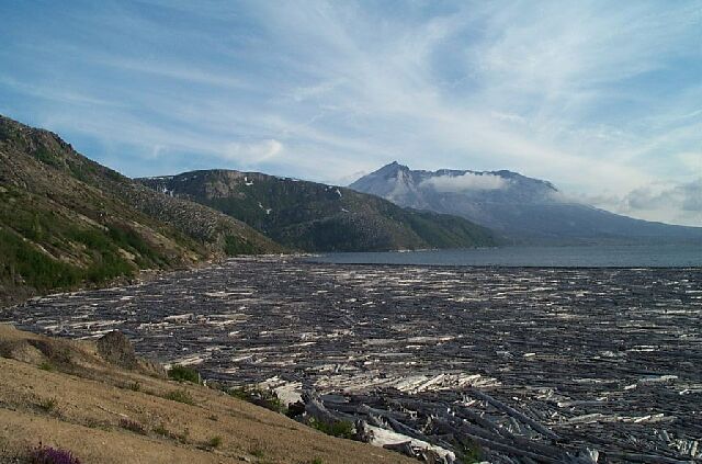
 I drove back onto teh main road and continued towards Spirit Lake. As you drive further you can see views of Mt Adams to the east, and the burned areas of St Helens in front of it. You can only imagine what could happen to Mt. Adams in the near future and it makes you realize what St Helens used to look like twenty years ago. I finally made it to the top at Windy Ridge. It was much colder up here. Come prepared by having a coat. It was a good day to be up here as there were few clouds and I had a good view of Spirit Lake. It always amazes me how many trees were left in this lake and why aren't there more like that in other lakes. I realize it was a valley and it stopped burning after it fell into the water. They estimate that the temperature of the lake was about 100 degrees F right after the eruption. The trees in
Spirit Lake may disintegrate over time and become a petrified forest. The lake is also a mile longer and 200 feet deeper after the eruption. On the north side of the lake they have built a tunnel underneath so that they can let water out of Spirit Lake when it gets too high and there is no fear of flooding the lower valley. The tunnel, reseeding of trees and the logging of many of the blown down trees by Weyerhaeuser are the three activities that have occurred here providing a better environment for recovery from the eruptions.
I drove back onto teh main road and continued towards Spirit Lake. As you drive further you can see views of Mt Adams to the east, and the burned areas of St Helens in front of it. You can only imagine what could happen to Mt. Adams in the near future and it makes you realize what St Helens used to look like twenty years ago. I finally made it to the top at Windy Ridge. It was much colder up here. Come prepared by having a coat. It was a good day to be up here as there were few clouds and I had a good view of Spirit Lake. It always amazes me how many trees were left in this lake and why aren't there more like that in other lakes. I realize it was a valley and it stopped burning after it fell into the water. They estimate that the temperature of the lake was about 100 degrees F right after the eruption. The trees in
Spirit Lake may disintegrate over time and become a petrified forest. The lake is also a mile longer and 200 feet deeper after the eruption. On the north side of the lake they have built a tunnel underneath so that they can let water out of Spirit Lake when it gets too high and there is no fear of flooding the lower valley. The tunnel, reseeding of trees and the logging of many of the blown down trees by Weyerhaeuser are the three activities that have occurred here providing a better environment for recovery from the eruptions.
 As I drove back, I stopped at Harmony Viewpoint to see a different view of Spirit lake. This is named after Harmony Falls as there used to be a resort here that was accessible by boat. There is now a trail that is a mile long and went to the east rim of Spirit Lake where all of the trees where all the trees are floating on the lake. Nobody was parked there and I thought it might be a quiet walk to try and re-live what had occurred here twenty years ago. It was eerie walking thru the burned tress and many limbs of trees laying on volcanic ash. There was the sound of birds chirping as I walked down the trail and when I was at the bottom I heard frogs croaking. At least life had come back here. Once down to the lake, it was a different perspective of what had happened. You see this large mountain that has half of it's cone blown away and you know it's sitting in Spirit Lake. There used to be cabins along here and a road but there is no trace of that now. The lake reminds me of the mill ponds that I used to work at in Weyerhaeuser. The wood though is not fresh as it looks like drift wood that has been sitting on the beech for several years. As I walked along the beach I saw the waterfalls and small creeks that ran into the lake. There were also patches of sand that kept falling into the creek and a tree on top of a sandbar. I wondered how it held the weight of the tree. You cold only imagine what kind of hell it would have been for anybody here twenty years ago and how peaceful and quiet it is now. It took me an hour to walk back up. I was exhausted by the time I got to the truck. I grabbed a can of pop and started driving back down the mountain.
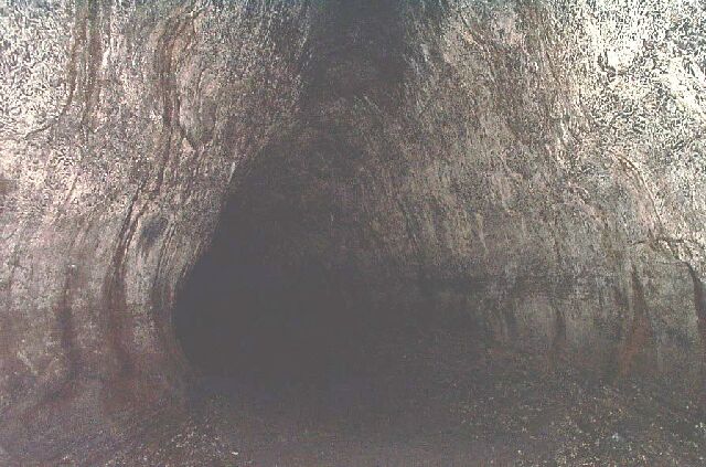
 It was afternoon now and I wanted to see the caves today. It would take an hour to get there if there was no traffic. I drove south on road 325 and passed the Mud River, Pine Creek info center and Swift Reservoir. I turned off on highway 83 and drove a couple miles before coming to the Ape Caves. There are two caves here as the lower cave takes about 45 minutes and is a tube cave that is easy to walk. The second cave takes a couple hours and is a mile long with difficult passageways. You will need a lantern or good flashlight. I took the easier of the two because I didn't want to spend all afternnon here. These caves were not discovered until the 50's. At one point I looked up and there was rock above me that was stuck between both walls that extended over me. It was also a little wet inside but no running water. I didn't see any bats today, although they are here inside. I took a couple about six pictures hoping they would turn out.
After leaving the caves it was time to start thinking about where I was sleeping. I was tired from walking all day and wanted a bed tonight. That left only one choice, as Courgar was a small town at the bottom of the hill. There was only one hotel here as I stayed at the Lone Fir Resort for $40. The room was old but clean and had two beds. There were no telephones in the room but one availabe outside. I read for about an hour and then went to look for something to eat only to find out every place in town was closed. The one restaurent/bar had closed at 10:00 and so I went back to the room and went to sleep around 11:00
I drove 300 miles today and 1300 total