Saturday 8/19/00
Day 13:Bellingham, Mt Baker,Anacortis

 We
left Twisp at about 9 am. Wedrove past Winthrop because was to early to do
anything as we continued on Highway 20. We turned off at the small communitty
of Mazama. We followed the signs to the gravel road over Hart's Pass which
used to be a 3-foot wide wagon trail used as a supply route for miners in
the area. Luckily we only passed 1-2 vehicles because this road was pretty
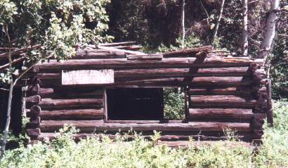
narrow. For the first few miles there were homes and a few abandoned cabins
along the road. There were campgrounds near Robinson Creek. It was a nice
view of mountains with some snow on their peaks We started seeing snow along
the side of the road as we climbed in elevation and finally came to where
we could go no farther due to snow on the ground. We realized we had been
following several other vehicles up here. These people seemed to know the
area and were getting out backpacks and cross-country skis. There was a ranger
station here and more campgrounds another 1 or 2 miles away which we could
not reach due to the snow cover on the ground. Part of the Pacific Crest National
Scenic Trail, a 2600 mile trail from Mexico to Canada, was not far from here.
We let the kids get out and play in the snow in the middle of July. On the
way down we passed a few vehicles and stopped at the first campgrounds we
had seen. The ranger there said they were full last night. On the way back
we stopped at the Mazama general store which appeared to be for the yuppie
looking for expresso, trailmix or a goumet sandwich, fishing gear and expensive
outer wear. Later we saw this area described as the 'Beverely Hills' of the
valley due to the high land prices.
We
left Twisp at about 9 am. Wedrove past Winthrop because was to early to do
anything as we continued on Highway 20. We turned off at the small communitty
of Mazama. We followed the signs to the gravel road over Hart's Pass which
used to be a 3-foot wide wagon trail used as a supply route for miners in
the area. Luckily we only passed 1-2 vehicles because this road was pretty
narrow. For the first few miles there were homes and a few abandoned cabins
along the road. There were campgrounds near Robinson Creek. It was a nice
view of mountains with some snow on their peaks We started seeing snow along
the side of the road as we climbed in elevation and finally came to where
we could go no farther due to snow on the ground. We realized we had been
following several other vehicles up here. These people seemed to know the
area and were getting out backpacks and cross-country skis. There was a ranger
station here and more campgrounds another 1 or 2 miles away which we could
not reach due to the snow cover on the ground. Part of the Pacific Crest National
Scenic Trail, a 2600 mile trail from Mexico to Canada, was not far from here.
We let the kids get out and play in the snow in the middle of July. On the
way down we passed a few vehicles and stopped at the first campgrounds we
had seen. The ranger there said they were full last night. On the way back
we stopped at the Mazama general store which appeared to be for the yuppie
looking for expresso, trailmix or a goumet sandwich, fishing gear and expensive
outer wear. Later we saw this area described as the 'Beverely Hills' of the
valley due to the high land prices.

 We
continued West on Highway 20 stopping to take pictures of the view every few
miles. We stopped to look at Ross Lake and Diablo Lake where there was a dam
we walked out across. Before reaching Newhalem we walked across the Gorge
where there was a bridge. You could actuially see the water running under
the bridge as you were standing on it. The bridge was closed at one end due
to construction. They were building a parking lot, sign posts and trails here.
We continued on Highway 20 and took a one-lane bridge to the North Cascades
Visitor Center in Newhalem. This was a nice center with a gift shop and helpful
rangers. It was early afternoon and we were getting hungry. We turned south
on highway 530 hoping to find something to eat in Darrington. This was a small
town containing mostly homes and grocery stores. We decided to continue on
to Arlington. We came into Arlington from the backside of town and discovered
that this weekend was the Arlington Festival, which included a street fair
and art show on Olympic Avenue and a Fly-in at the airport. . Olympic Avenue
was full of booths selling artwork and food. A band was playing Savoy Brown
music, the youngest member was about ten years old on drums
We
continued West on Highway 20 stopping to take pictures of the view every few
miles. We stopped to look at Ross Lake and Diablo Lake where there was a dam
we walked out across. Before reaching Newhalem we walked across the Gorge
where there was a bridge. You could actuially see the water running under
the bridge as you were standing on it. The bridge was closed at one end due
to construction. They were building a parking lot, sign posts and trails here.
We continued on Highway 20 and took a one-lane bridge to the North Cascades
Visitor Center in Newhalem. This was a nice center with a gift shop and helpful
rangers. It was early afternoon and we were getting hungry. We turned south
on highway 530 hoping to find something to eat in Darrington. This was a small
town containing mostly homes and grocery stores. We decided to continue on
to Arlington. We came into Arlington from the backside of town and discovered
that this weekend was the Arlington Festival, which included a street fair
and art show on Olympic Avenue and a Fly-in at the airport. . Olympic Avenue
was full of booths selling artwork and food. A band was playing Savoy Brown
music, the youngest member was about ten years old on drums
We drove next to I-5 and would drive for about an hower before coming to the little town of Bellingham. The town is located on the Bay that overlooks the SanJuan Islands. This is a older town with many older buiildings and also a college town as Western Washington University students live here also. I like coming to this town as there are many book stores heres that have good prices and also many littlew restaurents that serve good food here. The whatcom county museeum is locate here in a building that was built in 1892 and was once the City Hall. Cindy and I go to a couple of the book stores as we find cheap proices here on Canadian book as we preparee for future trips. We take a chort trip down to thewaterfron and also walk along the business.

 We
took north on highway 542 from Bellingham and take what isalso know as the Mt
Baker Sunset highway. This is a 55 mile trip to hemountains and is a nice view
today whicuy you can see form Interstate five. The travel begins by drivien
thur farmland and eventually follows the Nooksack River. The mountain does not
get as as much media attention as Rainier or St ahelens but it isjust as impressive
in itsown wasys. It is 10,778 feet high is ont asbusy as Mt Raineir because
the itis not located aroudn urban areas. Ther eused to be alot of mining here
also intheearly 1900's. we drove to the end ofthe road and therer were several
peopl u her taking pictures of Mt Baker today. I was here druignthe fall which
showed teh leaves turing and made for great pictures. ther are also many trail
that you can take inthe forested area before getting tothe top. I would recommend
taking a day to comehere and plan on a picnic with also some hiking. We were
up here for an hour before driving back to I-5forer readchingthe wos the areahte
We
took north on highway 542 from Bellingham and take what isalso know as the Mt
Baker Sunset highway. This is a 55 mile trip to hemountains and is a nice view
today whicuy you can see form Interstate five. The travel begins by drivien
thur farmland and eventually follows the Nooksack River. The mountain does not
get as as much media attention as Rainier or St ahelens but it isjust as impressive
in itsown wasys. It is 10,778 feet high is ont asbusy as Mt Raineir because
the itis not located aroudn urban areas. Ther eused to be alot of mining here
also intheearly 1900's. we drove to the end ofthe road and therer were several
peopl u her taking pictures of Mt Baker today. I was here druignthe fall which
showed teh leaves turing and made for great pictures. ther are also many trail
that you can take inthe forested area before getting tothe top. I would recommend
taking a day to comehere and plan on a picnic with also some hiking. We were
up here for an hour before driving back to I-5forer readchingthe wos the areahte
We got into town around 8 pm. Anacortes is a good size town. Most people don't realize that this town is actually on Fidalgo Island, mainly because it is linked to mainland by a bridge. We walked up and down Commercial Avenue which has lots of little shops, bookstores and restaurants. We finally decided to eat dinner at Bella Isola Restaurante. It was a busy Itallian restaurant full of locals and families. The food was good, but unfortuanately we sat at the noisiest table in the restarurant as the kitchen was on the other side of the wall and they were making a lot of noise in there. I had tiget shrimp and Cindy had a chicken dish as both were good and they served goo homemade bread. We drove around looking for the motel near the ferry terminal that we had stayed at before, but couldn't find it. We also drove around Washington Park, which is a large campground near the ferry terminal. It was too crowded with lots of families and not much privacy. We finally choose to stay at Paul's Motel on Commercial Avenue. It was a clean, no frills, one-story motel, which charged $46 for the night.
We drove 300 today and 3800 total