Name: Old Loggers Path
Where: Masten, PA
Distance: 44.7 km (27.8 miles)
Type: Loop trail
Difficulty: Easy to Moderate with few rough spots
Time to Complete: 3 days, 2 nights
Vertical Rise: 1020 meters (3340 ft)
Highlights: Streams, mountain springs, spanning views, waterfalls, and an old ghost town.
Water: Abundant, but probably dry at times Blazes: Orange rectangles (1 straight - 2 turn)
Directions: 45 minutes from Williamsport, PA - Take US-15 N for 11 miles to PA-14 N at Trout Run for 9 miles. Then make a right onto Pleasant Stream Rd for another 9 miles and you're there. With your back to the trailhead, go left, back up Pleasant Stream Rd., and the start of the trail will be on your right.
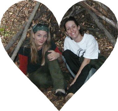
Day 1 - Sept. 30, 2002 *5 in party* Alexander, Brandy, Curtis, John, and Mary Anne (first time hiker)
You see it's my birthday and we were at this bar... Anyway we're at the trailhead, still hung over, no map, it's around 4:30 PM and we're looking at about 3 hours of daylight left, tops.
Then, just as we're about to get started, a young couple on mountain bikes roll in as they finish the trail. They gave us a map, wouldn't take any money or food for it, and were really great people all around. Ah, trail magic in action!
We passed the first campsite about a mile in. We didn't get to another for about 3 more miles, and it was already twilight. The mile 4 campsite was too small and on uneven ground so we turned on the headlamps and flashlight and kept going.
This was my first experience night hiking and wasn't as bad as I thought it would be. Everybody was pretty ok with it, even Mary Anne - and this was her first trip ever! Well, actually, John the Exaggerator would later tell tall tales of nearly falling headlong down 75 foot cliffs on a trail 4 inches wide. I think we did miss out on some good views though, because I heard a stream running alongside the trail for a couple of miles.
Anyway, an hour in the dark and two miles later we find a campsite at mile 6.37, and get to setting up in the blackness of night. There was a stream close by and we could hear rushing water in a few directions. I couldn't wait to wake up the next day to see it all.
Oh yeah, Brandy brought a little tea light candle and they all sang to me for my birthday. That was thoughtful, I appreciated the gesture and the extra pack weight. ;-) We all stayed up past midnight, laughing and making fun of each other.
Trails
OLP Guidebook


Ugh! Late start again. But at least we woke up to beautiful waterfalls surrounding the camp. Most of the group got going at 11:45 AM. Curtis and I, giggling genius explorers that we are, decided to blaze our own shortcut of a quarter mile to cut out almost 2 miles of trail. The only problem: it was about a 75 degree incline going up about 500 feet. About a hundred feet up, I decided that this climb wasn't for me and I was going to cut my losses, get down, and hike back to the trail. But it was too steep for me to get down. So we kept going, with Curtis clawing the dirt on all fours and pulling me up onto a ledge by my hiking stick at one point. Also, I went to lean against a tree, and the whole thing fell over and down the slope, almost taking me with it. Anyway, it took us about a half hour give or take but we finally got back up to the trail.
At this point Curtis and I had no idea if we were ahead or behind the rest of the group. Spider webs across the trail and an unsigned register box pretty much confirmed that we were out in front. Apparently, John was smoking on his way up the mountain and had to stop every few feet. Unfortunately, Curtis and I missed a sweet waterfall by taking the shortcut; we'll have to check it out next time we hit the OLP.
We stopped for lunch at Doe Run. I burned my hand a bit while lighting my stove, dropped it, and caught a few things on fire including: the ground, my socks, and John's sleeping bag. I doused the fire with about a liter of our drinking water, treated my hand (1st degree - no biggee) and apologized to all for being an idiot.
At about mile 11, Mary Anne stumbled onto, and nearly speared with her hiking stick, a big (maybe 5 ft.) rattlesnake sitting right on the trail. Both the snake and hiker jumped back immediately and the reptile took up a defensive coil, rattle going full speed. John didn't want to wait for the rest of us to catch up, and he didn't want to leave the snake on the trail, so he moved it with a long stick and chased it off. (He watched Animal Planet a few times, apparently this is enough training to be a snake handler. Boy, am I glad I bring a venom kit with me when I hike with heroes.) By the time the rest of us passed by the snake, it was still rattling, but from about 30 ft. off to the side of the trail. I yelled up ahead, "Hey, there's a rattlesnake back here!" To which I got a faint echoing reply of, "No Shit!"
Eventually it started getting late and I misjudged the distance to the next water source (where I assumed there would be a campsite) and what I thought would be a 5-10 minute hike, ended up being over half an hour. We reached the Long Run campsite at twilight about mile 14.75. John was ready to beat me with his hiking stick, he definitely didn't want to hike in the dark again.
Started the hike at 10:45 AM. That morning, John decided his feet hurt too much to go on. He told me he prefers camping to hiking and about a mile into it has me map out a shortcut back to the car. I directed him down Pleasant Stream Rd. which meets up with the trailhead - (about a 3 mile walk.) Mary Anne's feet were blistered and she didn't want to leave John alone, so she went with him.
I met up with Curtis and Brandy at the Pleasant Stream Crossing. It wasn't as bad as I thought it would be. The water was only a foot deep at most and I crossed it easily.
Next, we hiked up about 900 ft. over a mile and a half distance. It was the toughest climb of the trail with a beautiful panoramic view at the top (Sharp Top)
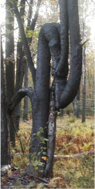
The rest of the trail went by really fast, we saw a lot of springs, beautiful scenery, and probably the strangest tree in PA. Curtis and I hiked a tenth of a mile off the trail to check out Sprout Point Vista. There was a simple campsite up there and a really nice panoramic view with a small lake a few miles out and below us. We left and found Brandy up ahead asleep on the trail. She thought the sign had said 1 mile instead of .1 mile and skipped it.
We were moving fast and the trail was quickly coming to an end. Darkness was approaching and we wanted to stay one more night on this Disney-like trail. We found a campsite about a mile before the trailhead and settled in a little after sunset. (At this point, I successfully taught Curtis and Brandy the chorus of "Convoy" with an added "Up yours!" at the end.)
We knew there wasn't far to go the next day so we ate nearly everything we had left in the packs. Stuffed bellies sleep deep, but we still heard what sounded like a woman screaming, tires chirping, and a gunshot. We figured it was local kids or maybe the ghosts of Masten. We were so tired, we couldn't have given a shit either way.

We started at 10:00 AM walking a little over a mile up to the trailhead and to our surprise, the car was gone. We dropped the packs and checked out the ghost town for awhile, then we split up to see if we could locate John and Mary Anne. They had been driving around looking for us where the trail intersected the roads and we all met around 11:30.
(Flashback) On Day 3, the two of them had made it back to the car, went to McDonald's and some stores in the area, and camped comfortably at the trailhead in Masten. They confirmed the noises we heard the night before and said it had kind of creeped them out too. Also that night, John had locked the keys in the car while it was running and as he was about to break a window to get in, Mary Anne figured out how to use a tent pole to hit the unlock button. So clever!
We all had a great time, even though we were separated for some of it. I've come to the conclusion that hikers and campers are completely different breeds. Total distance: 27.31 miles in 68 hours.
Over all, this trail really had a Disney feel to it; it was a challenge for the beginning hikers and was a pleasure for the rest of us. Call Tiadaghton State Forest for a camping permit and a free map. (We didn't, but you really should.) Also, be sure to filter your water, (Curtis doesn't, but I do - most of the time.)
Tiadaghton State Forest
423 E. Central Avenue
S. Williamsport, PA 17701
(717) 327-3450 or (570) 327-3450