Yellowstone
Day Hikes
This is by no means a complete listing of
Yellowstone's hiking possibilities. This is just a listing of a
few hikes that friends and I have enjoyed.
For a complete listing of trails and hikes look
at Mark C. Marschall's book Yellowstone
Trails: A Hiking Guide.
[
Text Only Version
]

[ Old Faithful Area ] [ Mammoth Area ] [ Norris Area ] [
Canyon Area ] [ Lake Area ]
or just click on the trail names on the map
above.
Old Faithful Area
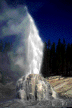
Lone Star Geyser
- 5 miles round trip. Almost level. This is one of my
favorite easy hikes. The trailhead is just upstream from
Kepler Cascades on the road from Old Faithful to West
Thumb. The hike follows an old road bed along the
Firehole river. Once you are away from the main park road
this is a very nice hike. Lone Star Geyser erupts from a
11 foot tall cone (third largest in Yellowstone) every 3
hours to a height of 40 feet. The major eruption lasts about 30
minutes and is usually preceded by one minor eruption that lasts
about 5 minutes. Ask the rangers at the Old Faithful
visitor center for more information about the geyser.
Plan to stick around for an eruption. It's a unique opportunity
to see a geyser in Yellowstone without the crowds.
About one half mile past the geyser is a
meadow in which I have seen wildlife in the past.
Mystic Falls Loop
- 3 miles round trip. 400 feet elevation gain. This
moderate hike leads through a small thermal area, then
through burned but re-growing forest, past a 75 feet tall
waterfall with a small thermal spring at the top, then
switch backs to an overlook of the entire Old Faithful
area. This hike probably provides the most variety of any
hike this short in the park. The hike starts at Biscuit
Basin (about 2 miles north of the Old Faithful clover
leaf.) Once at the basin parking lot, cross the bridge
and follow the boardwalk through the basin. Be sure to
take time to explore the basin. Jewel Geyser is a
frequent if small performer. It erupts every 10 minutes
in a series of burst that reach between 10 and 25 feet.
The trail leaves the boardwalk near the point furthest
from the parking lot. Follow this trail along the river
to Mystic Falls. Always keep the river on your left. Once
at the falls, you will switchback up the hill and then
onto the observation point. It is possible to view
distant eruptions of Old Faithful geyser from here.
From the observation point, the trail
leads back to the basin, completing the loop. Most of
this trail passes through forest burned in the 1988
fires and offers good opportunities to explore how the forest is
regenerating after the fires.
Observation Point
Loop
- 2 miles round trip. This is a relatively easy loop hike
with a 100 foot elevation gain. The trail leads off the
main boardwalk that leads from Old Faithful geyser to
Geyser Hill. Before taking the trail, check the Old
Faithful prediction so you can see the eruption from the
observation point. It takes about 15 to 25 minutes to walk
from the Old Faithful Visitor Center, where Old Faithful
predictions are posted, to Observation Point, so plan
accordingly. Beyond Observation Point, the trail passes
Solitary Geyser. This feature wasn't a geyser until, early
in the park's history, when a gouge was dug into the side of
the pool to drain water for a thermal bath formerly located
near Old Faithful Inn. As water was siphoned off and the pool's
water level dropped, the pool started to erupt as a geyser.
Eventhough water is no longer removed from the pool and
the gouge has been repaired for decades, the geyser still erupts.
It is amazing how easily Yellowstone's thermal features can be
radically changed by a careless act. Solitary currently erupts
about every 4 to 8 minutes in a quick burst to about 6 feet, though
20 foot bursts are occasionally seen.
Top
Mammoth Area
Beaver Ponds Loop
- 5 miles round trip. One of the parks few short loop
trails and one of the lowest in elevation, this trail is
a nice alternative early in the season when most of the
other park trails are still under snow. Because of the
lower elevation and warmer climate the trails in the
northern part of the park in general and around Mammoth
in particular tend to be clear of snow earlier than other
trails in the park. The best times to hike this trail are
in the Spring, May and June, and in the Fall.
From
October to June large animals migrate into the area. Your
chances of seeing large animals at this time of year is
very good. Besides the wildlife, in the Spring, wild
flowers are in bloom and in the Fall the aspen are
changing color. In the summer, the trail is too hot for
me.
The trail starts in a gulch between a grey
stone residence building and the Liberty
Cap formation at the base of Mammoth terraces. The trail
starts by climbing
400 feet in 1/2 mile but then levels out some. It passes
through forest and meadow and, of course, passes a number
of beaver ponds. Beaver are nocturnal so you probably
won't see them but you should see a good variety of
water fowl. The trail returns to Mammoth along a sage brush
plain. Look for Antelope along this stretch.
Top
Norris Area
Artist Paint
Pots
- 1.0 miles round trip. This is an easy, well developed
trail to some small, colorful and interesting thermal
features. While there is a small geyser and perpetual
spouter here, the main attractions are the colors and the
highly active but small mud pots. The mudpots are located
at the top of a low hill. The trail head is 4.5 miles
south of Norris Junction at the southern end of Gibbon
Meadows. This is a nice short hike and can provide a
perfect respite from summer traffic and crowds.
Top
Canyon Area
Clear Lake/Lily Pad
Lake Loop
- 5 to 6 miles round trip. This relatively easy loop trail
is possibly the the ultimate way to first see and
experience the Grand Canyon of the Yellowstone. The trail
is shown on the Grand Canyon Pamphlet available at the
Grand Canyon Visitor Center. There are two possible
starting points for this loop trail. Both starting points
are located on the south side of the canyon along the
South Rim Drive. The longer starts at the Wapiti
trailhead located at the picnic area just past
the Yellowstone River bridge on the South Rim Drive.
The shorter starts at the trailhead just across the road
from the parking area for Uncle Tom's Trail. No matter where you start,
I recommend taking the loop in the counter-clockwise
direction.
Starting at the Wapiti trailhead, the trail
first takes you into the Hayden Valley. It then leads back
into the trees where it joins with the trail from Uncle Tom's
parking area. The now joined trails lead to Clear
Lake, past some interesting mudpots and then to a
junction that leads past Lily Pad lake and onto the South
Rim Trail. The sign at this last junction was missing in
July 1997 so bring a map and watch for the junction.
The trail joins the canyon at the most colorful
portion of the canyon. Once the South Rim Trail is
reached, just follow it up stream until you reach your
car. Along the way you will see the most spectacular
portion of the canyon, including the Lower Falls. If you
started from the Wapiti trailhead, you will also see the
Upper Falls and the rapids above the falls.
Mt. Washburn
- 6 miles round trip. This is one of the premier short
trails in Yellowstone. Or perhaps I should say that THESE
are two of the premier trails in Yellowstone. There are
two routes to the lookout on the top of Mt. Washburn.
Both are about the same length and both climb about 1400
feet to the 10243' summit. The climb is not steep but it
is steady. The northern trail starts at the Chittenden
Road Parking Area. The southern trail starts at Dunraven
Pass (note this is not the same as the Dunraven Road
Picnic Area which is further south.) The view from the
top of Mt. Washburn encompasses the entire park but
expect it to be cool or down right cold at the top.
Along the trail you should see alpine flowers, small
animals and if you are lucky some very close views of
bighorn sheep.
Top
Lake Area
Storm Point Loop
- 2 miles round trip. The trail head for this very easy
trail along Yellowstone Lake is located 3.5 miles east of
fishing bridge. Water birds and large animals are often
seen in this area. Unfortunately, the trail sometimes
closes due to bear activity in the area so you might want
to check at the Fishing Bridge Visitor Center before
driving out to take the hike. (The end of the loop trail
vanishes a short distance before the end of the loop but
you can see the parking lot at this point.)
Elephant Back
- 4 miles round trip. The Elephant Back trail climbs 800
feet to the 8600' overlook at the summit of Elephant
Back. The overlook provides nice views of Yellowstone
Lake and the surrounding area. Moose and deer frequent
the area. Unfortunately, for the hiker that is, grizzly
bears fish in this area in May and June and at this time
the trail is often closed.
Top
[ Yellowstone Travel
Guide Index ]
[ Activities ]
[ Yellowstone Hiking ]
 Comments
and Questions are Welcome.
Comments
and Questions are Welcome.
This site is hosted by Geocities. Get your own Free Homepage.
The Lone Star Geyser
picture is from The Bear Man's Trailside.