Caving
| Since my first caving trip, whilst on Scout Camp in 1982, I have tried to get underground as
often as possible and have now made over 86 trips lasting over 190 hours in total. The majority
of my experience lies in the Forest of Dean in the UK, although I have also made trips in South
Wales, the Mendips and Yorkshire, and I am always keen to try new caves and mines. When caving
in the Forest of Dean I usually stay with David "Sparky" Parker who is extremely knowledgeable
about the whole area. I am a member of the BCRA
(British Cave Research Association) and the GSS
(Gloucester Speleological Society). |
|
** **
Caving is a potentially dangerous pursuit but with the correct training, equipment and expertise can
be immensely fun and rewarding. If you fancy having a go then you should join a local club and never
go underground without proper training, equipment and expertise. |
Take nothing but pictures, leave nothing but footprints.
Pick from the list below to see information and photos on some my favourite caves:
All photos on this page are © Oliver Hunter and may not be reproduced without prior permission
You can also look at my selection of caving links.
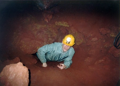
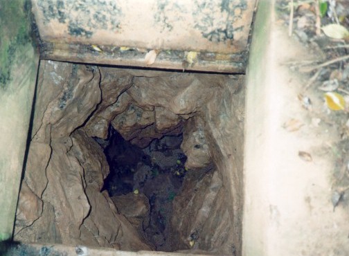
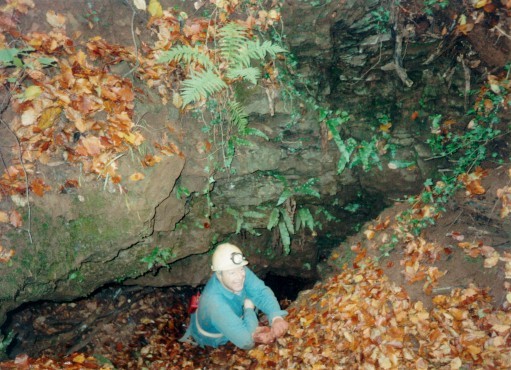
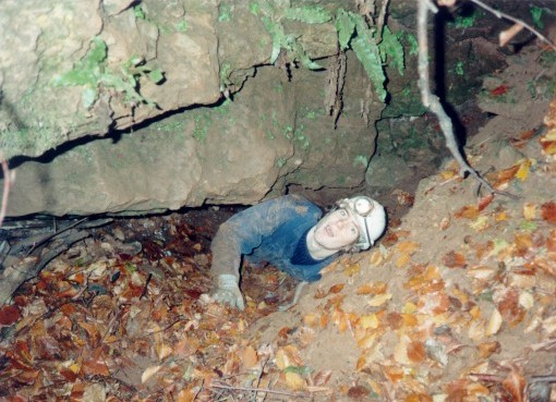
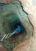
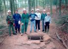
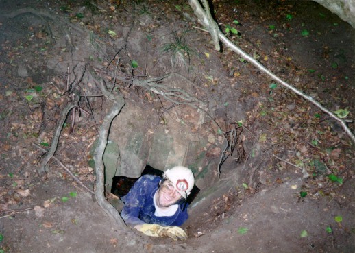
Brinchcombe Limestone Level

 Brinchcombe Limestone Level is a small system near Ruspidge in the Forest of Dean and is perfectly
suited for 'first-time' and young cavers with a complete exploration taking a maximum of an hour and a half.
The small entrance opens into a short tunnel ending in a squeeze leading into the main system which
consists of 1 main tunnel between 1 and 2 metres high and approximately 400m long. There is a 100m section
of parallel passageway towards the far end of the system which has 3 entry points but is has a sizeable amount
of spoil left from the mining operation. There is a vertical shaft leading up to the surface about halfway along
the system which the miners could have used to access the mine and which would also have provided some ventilation.
It is possible to abseil down into the system via the shaft but climbing up it is not recommended without ropes
from the surface as some parts are very loose.
Brinchcombe Limestone Level is a small system near Ruspidge in the Forest of Dean and is perfectly
suited for 'first-time' and young cavers with a complete exploration taking a maximum of an hour and a half.
The small entrance opens into a short tunnel ending in a squeeze leading into the main system which
consists of 1 main tunnel between 1 and 2 metres high and approximately 400m long. There is a 100m section
of parallel passageway towards the far end of the system which has 3 entry points but is has a sizeable amount
of spoil left from the mining operation. There is a vertical shaft leading up to the surface about halfway along
the system which the miners could have used to access the mine and which would also have provided some ventilation.
It is possible to abseil down into the system via the shaft but climbing up it is not recommended without ropes
from the surface as some parts are very loose.
The photos show Chris Horton in the entrance and Chris Whitehead (at back) with a party of Scouts at the far
end of the system.
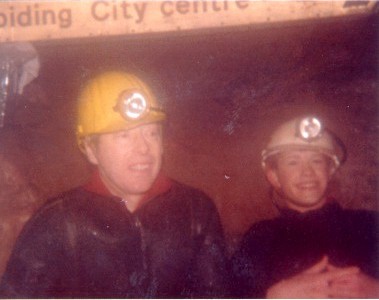
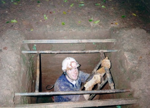
Dry/Wet Sink (Slaughter Stream Cave)
 I have only been on one trip down this cave and it was fantastic. I went with James Godding and John
Linford, with Anthony leading. The entrance is a huge affair descending several fixed ladders even
before the entrance is reached. Inside there is a fair sized cavern with a small hole leading downwards
into an even larger cavern. There are permanent anchor points for ladders and ropes which is useful as
the way down is a 50 foot free-abseil or ladder climb. Once properly inside, the main streamway is
quite impressive with the walls a couple of metres apart and about 10 metres high with a substantial
volume of water flowing through. There are some beautiful formations and features further in with 14km
of surveyed passages and the potential for many more. The photo shows James stood under a waterfall.
I have only been on one trip down this cave and it was fantastic. I went with James Godding and John
Linford, with Anthony leading. The entrance is a huge affair descending several fixed ladders even
before the entrance is reached. Inside there is a fair sized cavern with a small hole leading downwards
into an even larger cavern. There are permanent anchor points for ladders and ropes which is useful as
the way down is a 50 foot free-abseil or ladder climb. Once properly inside, the main streamway is
quite impressive with the walls a couple of metres apart and about 10 metres high with a substantial
volume of water flowing through. There are some beautiful formations and features further in with 14km
of surveyed passages and the potential for many more. The photo shows James stood under a waterfall.
A minus point of this system is that there is often pollution present in the main streamway which
eminates from a sewerage pumping station a short way up the valley. The local council decided that Dry
Sink would make an ideal dumping point for excess flows and a pipeline was constructed in the mid 1970's
with the message that it was only for use as an "emergency storm water and sewerage overflow facility".
Unfortunately it became very clear that the system was being abused and in 1991, after many complaints,
the NRA admitted "Malpractice at the pumping station" and promised that it wouldn't happen again. In
early 1997 the discharge was particularly bad and Central TV covered the story as a lead item in a May
bulletin but still the situation remains. Local cavers have contacted the Environment Agency, Welsh
Water and the local MP whilst continuing to monitor the situation.
Old Ham/New Dun
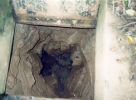
 Old Ham Iron Ore Mine is situated in between Milkwall and Sling to the South of Coleford in
the Forest of Dean. The entrance is gated and one used to be able to obtain a key for approximately Ł5 a trip
from the main office of the Clearwell Caverns show cave just across the road. It provided an excellent trip
for novices until recently when contamination, caused by chemical and waste dumping down the main shaft by
Watkins Ltd. (a local transport company) over many years, reached critical levels and forced the mine to be
closed by safety inspectors. There have been many ideas of how to solve the problem including drilling
bore holes down to ventilate the level. Greenpeace have been involved, but so far there doesn't seem
to be a solution in sight. Click here to see the latest in the ongoing saga.
Old Ham Iron Ore Mine is situated in between Milkwall and Sling to the South of Coleford in
the Forest of Dean. The entrance is gated and one used to be able to obtain a key for approximately Ł5 a trip
from the main office of the Clearwell Caverns show cave just across the road. It provided an excellent trip
for novices until recently when contamination, caused by chemical and waste dumping down the main shaft by
Watkins Ltd. (a local transport company) over many years, reached critical levels and forced the mine to be
closed by safety inspectors. There have been many ideas of how to solve the problem including drilling
bore holes down to ventilate the level. Greenpeace have been involved, but so far there doesn't seem
to be a solution in sight. Click here to see the latest in the ongoing saga.

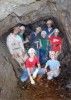
 The first picture shows a party of Scouts entering the cave while the second shows Sparkie in the
squeeze. The third photo shows Robert Booth coming down a shaft near the 'pipe shaft' which we used to
use for laddering practice, while the forth shows Neil and Steven in the '2nd pipe shaft'. The system
offers a variety of shapes and sizes of passage ways and 'churns' (excavated caverns). There are a few
natural formations but the most interesting features are the items of miners' equipment left in the
mine such as sleepers and rails in places, from the old ore-truck tramway. Other noteable features
in this system include, 'the squeeze', 'knob' rock, 'matchstick' rock, 'pop' rock, the 'pipe shaft'
and '2nd pipe shaft', the 'cathedral', and in one place there is an area containing hundreds of clay
models that succesive visitors have left, myself included, there's even a miniature stonehenge!
The first picture shows a party of Scouts entering the cave while the second shows Sparkie in the
squeeze. The third photo shows Robert Booth coming down a shaft near the 'pipe shaft' which we used to
use for laddering practice, while the forth shows Neil and Steven in the '2nd pipe shaft'. The system
offers a variety of shapes and sizes of passage ways and 'churns' (excavated caverns). There are a few
natural formations but the most interesting features are the items of miners' equipment left in the
mine such as sleepers and rails in places, from the old ore-truck tramway. Other noteable features
in this system include, 'the squeeze', 'knob' rock, 'matchstick' rock, 'pop' rock, the 'pipe shaft'
and '2nd pipe shaft', the 'cathedral', and in one place there is an area containing hundreds of clay
models that succesive visitors have left, myself included, there's even a miniature stonehenge!
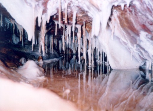
Otter Hole

 The entrance to Otter Hole was 'discovered' by local electrician George Gardiner in 1970 whilst
he was searching for Shakespeare's lost manuscripts which, acording to ledgend, were buried beside the
River Wye. He tried to enlist the help of local cavers to examine the hole, but only David 'Sparky' Parker
seemed interested. After an initial examination Sparky decided that there must be a sizeable cave system
within due to the strong draught issuing from the entrance. He spent 4 solitary years digging by hand to
enlarge the passge and eventually managed to get John Elliot and Bill Swartz interested. With their help,
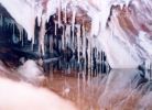
and the use of a small amount of explosives, they broke though on 14th September 1974. The system contains
some of the most impressive speleotherms Britain has to offer and proved that the Forest of Dean had the
potential for some huge cave systems. The complete story of Otter Hole including its discovery, biology and
hydrogeology and many photos can be found in Vol. 6, No' 4 of the Transactions of the
BCRA 1979.
The entrance to Otter Hole was 'discovered' by local electrician George Gardiner in 1970 whilst
he was searching for Shakespeare's lost manuscripts which, acording to ledgend, were buried beside the
River Wye. He tried to enlist the help of local cavers to examine the hole, but only David 'Sparky' Parker
seemed interested. After an initial examination Sparky decided that there must be a sizeable cave system
within due to the strong draught issuing from the entrance. He spent 4 solitary years digging by hand to
enlarge the passge and eventually managed to get John Elliot and Bill Swartz interested. With their help,
and the use of a small amount of explosives, they broke though on 14th September 1974. The system contains
some of the most impressive speleotherms Britain has to offer and proved that the Forest of Dean had the
potential for some huge cave systems. The complete story of Otter Hole including its discovery, biology and
hydrogeology and many photos can be found in Vol. 6, No' 4 of the Transactions of the
BCRA 1979.
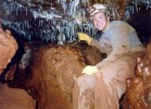
I was lucky enough to be part of a trip into Otter Hole with 10 others on 6th June 1994 when
attending the Forest Caving Symposium. We were underground for 6 hours which meant that
we had to carry ammo-tins with our lunches and high-energy foods in. The entrance series is tidal
and is very, very muddy due to the silt which is continually washed in. On reaching the tidal
sump one we had to wait a few minutes for the water level to drop sufficiently for us to pass
through. As the water runs out of the cave it makes loud gurgling and glooping noises partly like
a huge bath tub emptying.
Once inside the main system one has the opportunity to clean off in the streamway and, in fact, stay
reasonably clean until leaving the cave through the tidal sump when one gets coated in mud again. The
best part of my trip was reaching the Hall of Thirty where we turned round. The first picture shows
Jim Rumble at the point where the passageway enters the cavern stood next to a 'reasonably' sized boss
- others are much larger! The second pictture shows me after the trip absolutely shattered. Notice
how muddy I am - that's after I had been sat in a stream for 10 minutes cleaning myself...
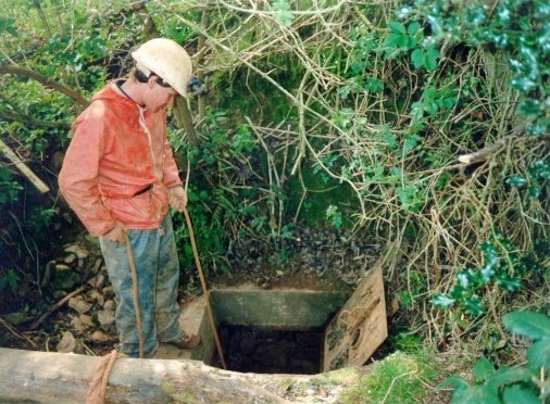
Seymour's Swallet

 Seymour's Swallet is a tight, wet, muddy little crack and I'm constantly surprised to find myself
returning to it again and again... :) It is only a couple of
hundred metres away from Hawthorn Swallet and less than half a mile from Wet Sink. The
cave just 'opened up' one night and since then has seen much activity to excavate it and keep it open
with the use of scaffold poles and much digging. The entrance has been concreted and gated although it
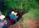
isn't locked. The first picture shows Ian Clere belaying a younger Scout into the cave while the second
shows a view looking straight down the entrance.
Seymour's Swallet is a tight, wet, muddy little crack and I'm constantly surprised to find myself
returning to it again and again... :) It is only a couple of
hundred metres away from Hawthorn Swallet and less than half a mile from Wet Sink. The
cave just 'opened up' one night and since then has seen much activity to excavate it and keep it open
with the use of scaffold poles and much digging. The entrance has been concreted and gated although it
isn't locked. The first picture shows Ian Clere belaying a younger Scout into the cave while the second
shows a view looking straight down the entrance.
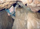
 Inside, the passageway is generally quite constricting and although there are some more spacious sections
they are few and far between. The first picture on the right shows Neil Mason on the fixed ladder while the
second and third show Chris "Soya" Foy and Chris Whitehead in more usual scenarios. Notable features
in this sytem are the 'Letterbox', the '90° bends', 'Cooney's Corner' where Nick Cooney got stuck, and
the high aven at the end.
Inside, the passageway is generally quite constricting and although there are some more spacious sections
they are few and far between. The first picture on the right shows Neil Mason on the fixed ladder while the
second and third show Chris "Soya" Foy and Chris Whitehead in more usual scenarios. Notable features
in this sytem are the 'Letterbox', the '90° bends', 'Cooney's Corner' where Nick Cooney got stuck, and
the high aven at the end.
Swildon's Hole
 Swildon's Hole is officially one of the wettest caves in Britain and the water running through
it has been proved by dye-tracing to feed the famous Wookey Hole although a physical connection has not yet
been found. I have only been down it once in 1987 (which is why I look so young in the photo - I
was only 16!) but I'm hoping that I'll get to go down again soon. It is a really fun trip and a
wetsuit is essential even on a short trip - there is a great ladder climb through a waterfall and
a few opportunities to do a spot of swimming. At one point early on there are two pools one below
the other and the water makes them like natural jacuzzis
Swildon's Hole is officially one of the wettest caves in Britain and the water running through
it has been proved by dye-tracing to feed the famous Wookey Hole although a physical connection has not yet
been found. I have only been down it once in 1987 (which is why I look so young in the photo - I
was only 16!) but I'm hoping that I'll get to go down again soon. It is a really fun trip and a
wetsuit is essential even on a short trip - there is a great ladder climb through a waterfall and
a few opportunities to do a spot of swimming. At one point early on there are two pools one below
the other and the water makes them like natural jacuzzis
Westbury Brook

 Westbury Brook is an Iron Ore Mine in the Forest of Dean and, after Otter Hole is
probably the muddiest system I have ever ventured into. There is an abundance of Red Ochre Clay
- the kind you probably had in pottery att school along with the grey stuff - and when mixed with
water this becomes really gooey and tacky.
Westbury Brook is an Iron Ore Mine in the Forest of Dean and, after Otter Hole is
probably the muddiest system I have ever ventured into. There is an abundance of Red Ochre Clay
- the kind you probably had in pottery att school along with the grey stuff - and when mixed with
water this becomes really gooey and tacky.
The entrance is tucked away at the back of a huge opening into the hillside and is gated as shown in
the first photo. It is an awkward entrance which leads down into a maze of 'passageways' all
following the vein of ore at quite a steep angle of about 50°. What follows is a mixture of huge
sports-centre sized caverns connected by some really tight muddy crawls. In one of these caverns
there is some impressive 'honeycombing' on the walls. The second photo shows Jim, Neil, Karen,
Pauline, Dave and Chris sat on a pile of muddy spoil - they were all clean before they started the
trip...
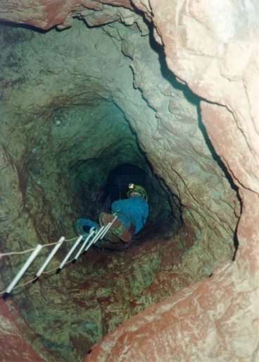
Wigpool
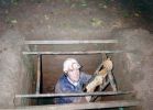 Wigpool is also an Iron Ore Mine and being only 2 miles North from Westbury Brook (see
above), has some similarities. It is muddy with the now familiar red-ochre clay although the angle of
the syncline that it 'lives' in is not so steep. The main entrance has been filled long ago and there
are rumours that one of the biggest shafts was blocked when an American tank fell down it. There are
three main entrances in use today: 'Steam', 'Foxhole' (or 'Foxes'), Swaypole and the lesser-used 'Meeks'
hole. 'Steam' is so called because on a cold day the entrance can clearly be seen to be steaming, caused
because the temperature inside the mine is constant all year round and in winter it is often warmer
underground than it is outside. Both routes are actually old escape routes that the miners would have
used in an emergency and the upper workings of the mine date back to Roman days. The mine closed at the
end of the last century but was briefly reopened during the Second World War. The first photo shows a
party about to enter steam and the second shows Chris descending.
Wigpool is also an Iron Ore Mine and being only 2 miles North from Westbury Brook (see
above), has some similarities. It is muddy with the now familiar red-ochre clay although the angle of
the syncline that it 'lives' in is not so steep. The main entrance has been filled long ago and there
are rumours that one of the biggest shafts was blocked when an American tank fell down it. There are
three main entrances in use today: 'Steam', 'Foxhole' (or 'Foxes'), Swaypole and the lesser-used 'Meeks'
hole. 'Steam' is so called because on a cold day the entrance can clearly be seen to be steaming, caused
because the temperature inside the mine is constant all year round and in winter it is often warmer
underground than it is outside. Both routes are actually old escape routes that the miners would have
used in an emergency and the upper workings of the mine date back to Roman days. The mine closed at the
end of the last century but was briefly reopened during the Second World War. The first photo shows a
party about to enter steam and the second shows Chris descending.
 The 'Steam' & 'Foxes' routes meet just before the first main level in the mine so a 'circular' trip can be
undertaken. There are several levels in the mine which consist of roughly circular fairly wide arch-shaped
passageways, although the lower levels are prone to flooding
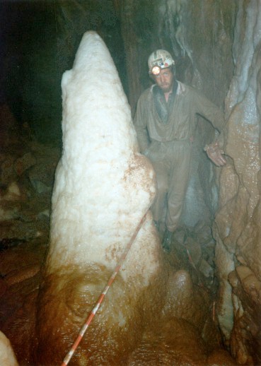
A little off the 'usual' route are some really beautiful formations if in miniature compared to those
in Otter Hole. The first picture on the right shows me pointing at some small straws, while the
second shows a pool containing some rare straw-pennants or 'crystal balls' which are formed as the
water level rises and falls, depositing calcite on the end of stalactites (straws) that are touching
the water.
The 'Steam' & 'Foxes' routes meet just before the first main level in the mine so a 'circular' trip can be
undertaken. There are several levels in the mine which consist of roughly circular fairly wide arch-shaped
passageways, although the lower levels are prone to flooding
A little off the 'usual' route are some really beautiful formations if in miniature compared to those
in Otter Hole. The first picture on the right shows me pointing at some small straws, while the
second shows a pool containing some rare straw-pennants or 'crystal balls' which are formed as the
water level rises and falls, depositing calcite on the end of stalactites (straws) that are touching
the water.

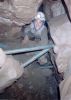
 Apart from the formations there are several points of interest including what remains of the stables
where the pit-ponies used to be kept, the old lift shaft and the only hand-winch in it's original working
position in an Iron Ore Mine in England. The two pictures on the left show Dennis Godding and Chris Horton
respectively leaving Wigpool via Foxhole. It is possible to make a through trip from Swaypole but,
even with Sparkie's help and knowing the general area to be looking in, I have been unable to make the
connection. I started exploring Wigpool entering via Swaypole in September 1998 with some of my friends, and
current finds are very exciting. All four entrances were gated in 1996 and all enquiries for access should be
made to Clearwell Caves, Clearwell, Near Coleford, Forest of Dean, marked for the attention of Ray or
Jonathan Wright.
Apart from the formations there are several points of interest including what remains of the stables
where the pit-ponies used to be kept, the old lift shaft and the only hand-winch in it's original working
position in an Iron Ore Mine in England. The two pictures on the left show Dennis Godding and Chris Horton
respectively leaving Wigpool via Foxhole. It is possible to make a through trip from Swaypole but,
even with Sparkie's help and knowing the general area to be looking in, I have been unable to make the
connection. I started exploring Wigpool entering via Swaypole in September 1998 with some of my friends, and
current finds are very exciting. All four entrances were gated in 1996 and all enquiries for access should be
made to Clearwell Caves, Clearwell, Near Coleford, Forest of Dean, marked for the attention of Ray or
Jonathan Wright.
Links

people have come this way since
1st May 2001
Back to the "about me" page
Back to the mainpage
 Brinchcombe Limestone Level is a small system near Ruspidge in the Forest of Dean and is perfectly
suited for 'first-time' and young cavers with a complete exploration taking a maximum of an hour and a half.
The small entrance opens into a short tunnel ending in a squeeze leading into the main system which
consists of 1 main tunnel between 1 and 2 metres high and approximately 400m long. There is a 100m section
of parallel passageway towards the far end of the system which has 3 entry points but is has a sizeable amount
of spoil left from the mining operation. There is a vertical shaft leading up to the surface about halfway along
the system which the miners could have used to access the mine and which would also have provided some ventilation.
It is possible to abseil down into the system via the shaft but climbing up it is not recommended without ropes
from the surface as some parts are very loose.
Brinchcombe Limestone Level is a small system near Ruspidge in the Forest of Dean and is perfectly
suited for 'first-time' and young cavers with a complete exploration taking a maximum of an hour and a half.
The small entrance opens into a short tunnel ending in a squeeze leading into the main system which
consists of 1 main tunnel between 1 and 2 metres high and approximately 400m long. There is a 100m section
of parallel passageway towards the far end of the system which has 3 entry points but is has a sizeable amount
of spoil left from the mining operation. There is a vertical shaft leading up to the surface about halfway along
the system which the miners could have used to access the mine and which would also have provided some ventilation.
It is possible to abseil down into the system via the shaft but climbing up it is not recommended without ropes
from the surface as some parts are very loose.