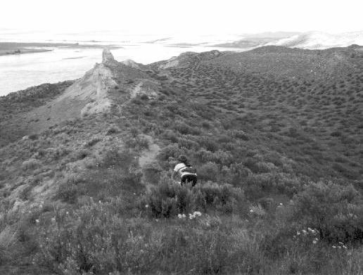
You've got the White Bluffs of the Wahluke Slope on your right side and the Columbia River on the left side. Across the river is the old Hanford townsite and the Hanford Nuclear Reservation. Ridge running along the Devil's Backbone (legend has it that money from a bank robbery was hidden here), swooping downhill into ravines and popping up the other side. The area and trail remind me of the pictures that I've seen of the trails around Fruita, CO. While this may not be the "best" singletrack in the Tri-Cities, WA area it IS the best "adventure singletrack", in my humble opinion.
TRAIL ACCESS ACTION ALERT (5/11/00)
TRAIL TYPE: Out-and-back on 100% mondo fun singletrack
DISTANCE: 12 miles round trip
TIME: 2-3 hours round trip
BEST RIDING: November thru April
CAUTIONS: After a rain, the trail can get pretty slippery. Almost everyone will be off their bike pushing at some point. There is clay in the soil and it will pack up your clipless pedals quick.
LAND OWNERSHIP: Recently, management of the area has been turned over to the US Fish & Wildlife Service. The Wahluke Slope will be added to the existing Saddle Mountain Wildlife Refuge. Responsible trail riding will maintain current access to the new wildlife refuge.
DIRECTIONS: From Pasco, go towards Richland on I-182. Turn right on Road 68. Where the road forks, take the bend to the right - that's Taylor Flats Road. Follow Taylor Flats for about 13 miles until it comes to a T, which is the intersection with Ringold Road. Turn left onto Ringold Road, follow it down a windy grade about 2.5 miles and keep alert as you approach an orchard on the left. You need to head toward the Ringold fish hatchery, which means a sharp left as you near the bottom of a hill. Unfortunately, that turn is somewhat obscured by the orchard. Once you make the turn and are facing the river, you'll come to another T in the road. Take a right onto Ringold River Road and you're nearly there. Stay on Ringold River Rd. (gravel) for about 9 miles to parking at the Public Fishing Access on the Columbia River (turn left just before the gate across the road).
TRAIL DESCRIPTION: A couple of hundred yards past the gate look to the right for a faint trail leading toward the saddle on the nearby ridge. Climb the saddle and continue up the trail negotiating a steep long challenging climb up to the rim. Take a left on the ridge and continue climbing. Follow the ridge down a steep decline through some "S" turns, across the paved road and up the next steep hill. Pause here to catch your breath and soak in the extraordinary scenery. Continue along the ridge upriver along the Devil's Backbone exercising caution to avoid perilous cliffs and soft areas. There is a large dropoff once you're past the Devil's Backbone. It comes up on you really sudden. The trail to the right will take you around the dropoff. It has been ridden but only attempt it if you're VERY certain of your descending abilities. Maintain a high cadence and attempt riding up the short steep rollers enroute to the turn around point. At about 6 miles out a recent landslide prohibits further travel. Watch out for large soil cracks near the end of the trail. Retrace the trail back and gain a new perspective on the hills that seemed steep going up.
TRAIL PHOTOS: Slide Show #1 (11/19/99) [Approx 1 min]
Slide Show #2 (1/00) [Approx 1 min]
Send me your pictures of the White Bluffs Trail.
TRAIL "LEGEND": "In the late 1860's, a small gold shipment was going by stagecoach to [the town of] White Bluffs when it was robbed. A posse chased the bandits, who supposedly stashed their sack of stolen gold in the bluffs across the river from the old Hanford townsite before they were captured. No one ever found the gold and later, the security buffer zone around Hanford's Cold War plants kept anyone from trying." Tri-City Herald Oct 3, 1999