|
|
Parking Along The Difficult Run Trail
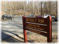
Georgetown Pike parking lot. Photo: Copyright ® 1998-9 by Chuck Thomas/Digital-Rose.
Public Parking
From North (Near the Potomac) To South
| Location |
How Far To Trail |
Directions |
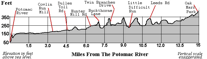
| Georgetown Pike County Lot, Route 193, 40 spaces, fills fast |
Trail is across stream from lot, but you must ford the stream |
From Beltway, Va. Rte. 193 West five miles, 1/2 block after crossing Difficult Run bridge, turn left. |
| Colvin Run Mill Park County Park, 60 spaces |
Trail is 2 blocks away, at foot of hill, crosses Rte. 7 at light at Carper's Farm Way |
From Beltway, Leesburg Pike (Va. Rte. 7) west five miles, right on Colvin Run Rd. (watch for Colvin Run signs), then left into park. |
| Browns Mill Road (on shoulder) |
on trail, 2 spaces |
From Dulles Toll Road (Va. Rte. 267), Hunter Mill Rd. exit, north. Right at stop sign (Crowell Rd. 675, becomes Browns Mill Rd, gravel shoulder, right side of road after bridge over D. Run |
| Hunter Mill Road, N.V.R.P.A. lot |
on trail/on W&OD Trail, 8 spaces, fills fast |
From Dulles Toll Rd (Va. Rte 267), Hunter Mill Rd. exit, south. At 2nd light, turn left (stay on Hunter Mill Rd.), lot is at crosswalk, at flashing yellow light. |
| Oak Marr County Park and Rec. Center |
on trail, 100+ spaces |
From I-66, Chain Bridge Rd. (Va. Rte 123) exit, north, left at second light (Jermantown Road), three blocks to Oak Marr Rec. Center on right, park in gravel lot to left. |
Related Sites
W&OD Trail Parking.
Use the trails wisely. The conditions of the trails may vary from the descriptions found here, due to external forces. This site strives to present accurate information, but it is subject to change. Never trespass on private property or violate any law. Do nothing which would be dangerous. As with any activity outdoors, hiking has risks. You assume responsibility for those risks.
The Difficult Run Trail is not well marked, and it is difficult to follow. Avail yourself of the maps available elsewhere in this web site, but also use caution before embarking on this trail for the first time by yourself. Check the link to the calendar section for organized hikes over this trail.
|