
|
|
|
|
|
|
|
|
|
|
|
|
|
|
|
|
Hike: Ha'iku Stairs |
Time Started: 11:31 AM |
Party: Doug, Hun, Chad Shimonishi, Alex Okihara | |
 After parking the car next to the Omega Station, we took a left on a trail leading
to the stairs. We jumped through a hole in the fence to get to the access road.
After parking the car next to the Omega Station, we took a left on a trail leading
to the stairs. We jumped through a hole in the fence to get to the access road. |
 We walked up the road for a couple of minutes, looking for the
stairs on the mountain.
We walked up the road for a couple of minutes, looking for the
stairs on the mountain. |
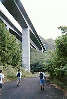
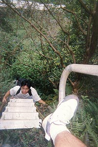
 We came to a clearing where the trail to the stairs began. The path takes you
directly underneath the H-3 freeway to the first metal steps. It had taken a
total of 21 minutes from where we had parked our car to this spot.
We came to a clearing where the trail to the stairs began. The path takes you
directly underneath the H-3 freeway to the first metal steps. It had taken a
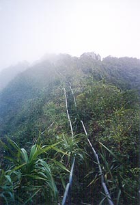
total of 21 minutes from where we had parked our car to this spot. The stairs start getting steep pretty fast. The trail was getting overgrown. In the
distance, you can see the white ladder on the steep near-vertical section.
The stairs start getting steep pretty fast. The trail was getting overgrown. In the
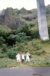
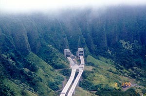
distance, you can see the white ladder on the steep near-vertical section. Looking behind us, we could see the H-3 freeway. The trail starts near the middle pillar
shown in the picture.
Looking behind us, we could see the H-3 freeway. The trail starts near the middle pillar
shown in the picture.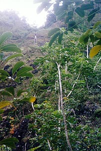 Here is a closer shot of the ladder.
 The trail alternated between steep climbing and fairly level walking.
More clouds rolled in as we approached the first ladder (left). The ladder was the first scary part. You have to totally trust it and the rope that lies to the left of it. The section is near-vertical and extends about 7 feet or so. Here's Chad at the middle of the ladder.
 Then it was my turn. As you can see, the ladder was fashioned out of aluminum, PVC, and rope.
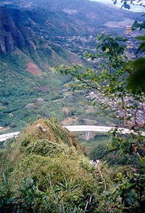
 The views along the trail are spectacular. To the left are the tunnels going into the Ko'olaus.
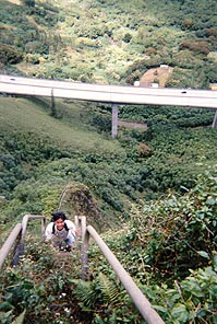
 Higher up, the H-3 freeway started to appear smaller. Somewhere around here, we came to a
second ladder. The second ladder was a little bit longer, but didn't seem as scary.
We crossed the ladder and continued to climb. After about an hour, we reached the first flat
section that had an I-shaped concrete foundation.
Higher up, the H-3 freeway started to appear smaller. Somewhere around here, we came to a
second ladder. The second ladder was a little bit longer, but didn't seem as scary.
We crossed the ladder and continued to climb. After about an hour, we reached the first flat
section that had an I-shaped concrete foundation.
 Along the way, we encountered Daryn Ohta (left) with a group of people. Daryn and his
group were descending from the top. They were nice enough to back up about 20 feet or so
to a flatter area. They stood on the outside of the stairs to let us pass. Thanks Daryn!
We talked story for a while and then proceeded up again.
Along the way, we encountered Daryn Ohta (left) with a group of people. Daryn and his
group were descending from the top. They were nice enough to back up about 20 feet or so
to a flatter area. They stood on the outside of the stairs to let us pass. Thanks Daryn!
We talked story for a while and then proceeded up again.
 We then reached a flat section with an I-shaped concrete foundation. We continued to
climb, hitting steep sections followed by short flat sections.
We then reached a flat section with an I-shaped concrete foundation. We continued to
climb, hitting steep sections followed by short flat sections.
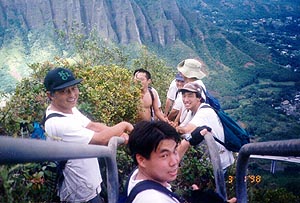
 Here's Doug and Hun making their way up the stairs. In the backdrop is the wonderful
Windward side.
Here's Doug and Hun making their way up the stairs. In the backdrop is the wonderful
Windward side.
 We passed several other flat sections and came to a concrete housing. It was so overcast
up there that we couldn't see the nice views. Bummers! In the mist, you can see the
concrete structure at the top.
We passed several other flat sections and came to a concrete housing. It was so overcast
up there that we couldn't see the nice views. Bummers! In the mist, you can see the
concrete structure at the top.
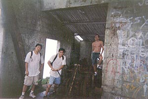 Inside the concrete building are the remains of some old machinery. The machinery appears
to have been used to haul things up the side of the mountain. This is just a guess.
Inside the concrete building are the remains of some old machinery. The machinery appears
to have been used to haul things up the side of the mountain. This is just a guess.
 The clouds broke momentarily, allowing for a nice picture of the windward side.
 The clouds quickly engulfed us once more.
 The trail continued its rise.
 Here we are at the second concrete building taking a little breather before continuing.
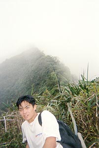
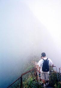 It started to get really cloudy at the top, and we had trouble seeing what lay ahead of us.
In the picture, you can see the outline of the steep climb ahead.
It started to get really cloudy at the top, and we had trouble seeing what lay ahead of us.
In the picture, you can see the outline of the steep climb ahead.
 Some of the sections at the top are covered with rust and are disjointed, causing us to
tread with care.
Some of the sections at the top are covered with rust and are disjointed, causing us to
tread with care.
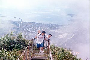
 Finally, we made it to the top. Here is the final concrete structure with the two
satellite dishes. It's time to celebrate!
Finally, we made it to the top. Here is the final concrete structure with the two
satellite dishes. It's time to celebrate!
 Yum, yum! It's zip pac time!
The Story:
Today, we had originally planned to check out Hawaii Loa Ridge, but we decided to do Haiku Stairs instead. Chad had already told Hun and Doug that we'd be going to Haiku Stairs. Since I had never been to Haiku Stairs, I didn't mind the change in plans.
The only problem was that we didn't know where the trail began. A quick search on the web at some hiking sites did not reveal any instructions to the trail head. Grant Tokumi had previously told me which road to turn down, so we had some general idea of where to start off. Also, on the web, there was a note saying that you had to walk through a hole in the fence. So off we went, turning onto Haiku Road from Kahekili in search of the trail.
After driving around for a couple of minutes and seeing nothing but houses, we came to a road with a chain blocking the path. The road leads to the Omega Station which was recently closed. It appeared that it would lead to Haiku Stairs. However, we continued to drive around, checking some of the side streets that we had passed on the was, just in case there was another trail elsewhere. We found nothing and returned to the Omega Station.
Working at the United States Geological Survey, I was already familiar with the Omega Station. Before the main gate, there are two trails, one to the left, and one to the right. The trail to the right leads to Haiku Stream, where there are two gage houses that record hydrologic data. There is also a nice pool where people go to swim.
The trail to the left headed toward the H-3, which is where we wanted to go. So we went down the trail and found the hole in the fence that was describe on somebody's Web Site (I think it was Dayle Turner's). We ducked through the fence and found ourselves in a bamboo forest. The trail is very clear, and there are markers in key places. Along the trail, we came to several clearings and more bamboo. Eventually, we hit another fence with a hole in it. We ducked through the fence and ended up on a road.
We walked up the road for a couple of minutes, all the while trying to find where the stairs were on the mountain. We came to a clearing on the left side and what do you know? That is where the stairs began. We found it! The path takes you directly underneath the H-3 freeway to the beginning steps. It had taken a total of 21 minutes from where we had parked our car to this spot.
From the bottom you could see the stairs leading to the top and a section where a ladder fashioned of aluminum, PVC, and rope lay.
We ascended the stairs. Up and up we went, and steeper and steeper they got. More clouds rolled in as we approached the first ladder. The ladder was the first scary part. You have to totally trust it and the rope that lies to the left of it. The section is near vertical and extends about 6 feet or so.
After crossing the ladder we continued our ascent. After several breaks, we came to a second ladder. This ladder was a little bit longer. We crossed the ladder and continued to climb. After about an hour, we reached the first flat section that had an I-shaped concrete foundation.
It took us an hour and 35 minutes to the second flat section with another I-shaped concrete foundation. We continued to climb, hitting steep sections followed by short flat sections. Along the way, we encountered Daryn Ohta with a group of people. Daryn and his group were descending from the top. They were nice enough to back up about 20 feet or so to a flatter area. They stood on the outside of the stairs to let us pass. Thanks Daryn! We talked story for a while and then proceeded up again.
We passed several other flat sections and came to a concrete housing. It was so overcast up there, and we couldn't see the nice views that exist up there. Bummers!
After an hour and 50 minutes, we reached the top. There are two satellite dishes on top of a concrete structure. There is a lot of vandalism on the walls and on the dishes themselves. We climbed to the roof and broke for lunch. Zip pacs again!
At the top, it was still cloudy, but it was clear in some areas. We could see Pearl Harbor and all the way to Mt. Ka'ala. It was a very nice view. Then it started clouding over. I was bummed because I couldn't take any panoramic shots.
After cruising around for a bit on the roof, I looked to my watch to see what time it was, and discovered that my watch had gone bonkers! My watch read 12:00 AM, and I was bummed again. Oh well, the watch lasted me 8 years of wear and tear, through surf and snow. Thanks watch!
We then proceeded to go down. Going down was pretty scary, especially at the really steep sections. I went backside for these, and climbed down like I was climbing down a ladder. The sensation made me feel really weird because everything seemed upside down. So I alternated going down the stairs by walking forward and backward.
The ladders were scarier going down than going up. It had started to drizzle lightly, which made everything more slippery, including the hand rails.
When we finally got to the bottom of the stairs, we were walking back to the road. My friend Chad started slipping left and right. He fell a total of five times in about 20 seconds. He was not seriously injured, so when he fell, it was pretty funny. The ground was too wet for his shoes with no grip.
Notes: Haiku Stairs can be especially scary when it starts getting wet. There are some scary sections were the hand rails are missing. There is a lot of rust on everything. It is also very steep. It would be a good idea to bring gloves on this hike because my hands felt pretty raw after gripping the hand rails for so long. I am surprised I didn't get any blisters.