|
Description of place
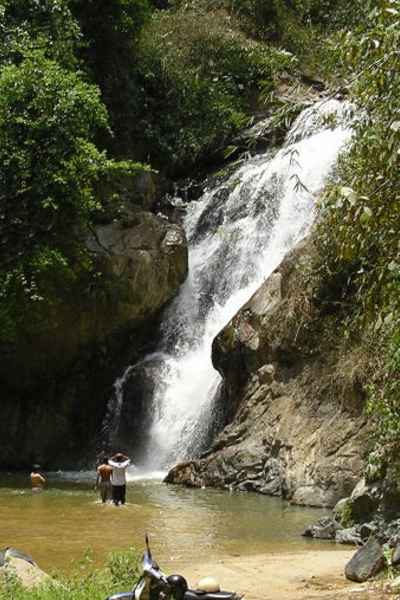
The waterfall is on Sungei
Dua Olak and flows down from the low hills running paralleled to the
Karak Expressway. It would be a fair length river by the time it
reaches the plain to join the main Pahang river. During that long
journey the river had assembled a good
volume of water from having traveled about 20 kilometers. Typical of
rivers from low hills, even with increased volume of water during flash floods,
flow length is short. Volume not
strong enough to cut deep gorges. Sungei Dua Olak is no different. The
river at many points was running next to the road at almost the same
level. Then at this point of the Lata Khong waterfall, the river
flowed over a bed of granite before it overflows. That was the
waterfall.
I would describe this
waterfall as a beautiful single drop into a good size pond. Again,
there was no evidence of flash flood, the local found it safe to have
a permanent road from the main track down towards the area of the
waterfall. Just to reach the pool below the waterfall.
Outdoor enthusiasts,
ranging from those associated with the 4X4 vehicles and those from the Mountain
bike had picked this vicinity. They can get 25 kilometers trails for their
outings. Their modus operandi would be to trace the flow of Sungei Dua Olak,
well most of the
way, until the terrain beats them. I understand that somewhere up in the higher grounds,
mountain bikers could follow a trail to meet another trail coming in
separately from the Karak Highway. Then that new trails continues into the valley and up
another hills towards the Janda Baik track. It is obvious that the
pioneer who created this trail has found better that a better target. The need to reach the river's
source is not on his priority.
Coming back to this Lata
Khong, the name of which we ourselves gave, is very natural. Across
the pool sheltered by a steep slope was a fairly large clearing, that
easily could accommodate over 10 tents. Visitors would drive their
vehicles across the pool to where they set camps. The pool is deep
enough to do some swimming and the whole enclave surrounded by
pristine jungles. Most part of the pool had very shallow water and its
total size should be within a diameter of 30 meters .
It is extremely popular
and over the weekends, the small camping sites would be filled to the
brim. Luckily most visitors are of the serious outdoor type. A
different type of "crowd"
What is recommended
I would
say that this destination is close to ideal. Ideal in the sense that
those seeking for an outdoor life and to spend time on their own in the
wilderness. They would find the conditions here.
So bring all your gears and your
gang. Everything is possible here. The only limitation as I can see
it, there
is no target for jungle trekking.
You
could do some exploring like walking up and back to the main track, plot
your way a little upstream. Then down into the ravine at some point.
There you could find the upper reaches which is the top of the
waterfalls and yes, there is another waterfall.
Get
more pictures from this link
|