|
The place?
Scenario 1- This signage on the
board hinted that you need a off road vehicle to use the trail to the
waterfall! When you see my photo page you can imagine the type of
terrain, condition and
hardened surface you will be traveling on for the next 10 kilometers.
Use your own discretions. The road, steep at a couple of points hugged
the side of a steep slope. Meaning - on one side of the track the
sheer drop, the drop
is quite dramatic. See the view of the valley when you are driving
along this track. At the end of the trail is a lavish car
park. Of course, most of the vehicles are 4X4s. This place was their
haven before the permanent track was established. Observe the
inconsistencies in road surfaces. The track was so well
hardened that with a bit or care, small car like Kechil can make
the trip. From the car park area, a bridge will help you to cross
the river, to go the Waterfall way.
A word of caution
though! On the last leg, at one point of the track, water had washed
away some top soil, exposing the boulders underneath. The unevenness
may cause some concern to small sedan but light sedan can
make it through this one point, extreme care needed. If you are uncomfortable
and do not want to
damage the undercarriage of your car, watch for this first bridge. You could park your car here and walk the rest of the way. The
walking time should be less than 60 minutes. At the parking area,
there is this sign. A trail to the peak. Watch it, this is not a low
mountain.
Scenario 2 - I went back my Suzuki Vitara with full confidence. The
hardened track was so badly eroded that a conventional car could not
pass by the deep crevices in the middle of the track. To make
matters worse, heavy duty 4X4 has carved side tracks on the hills
side and a steep drop on the other. I
would say that track is no longer passable except to organized
members of 4X4 club.
Scenario 3 - The tour operator had doubled up this ride to the
Waterfall as an adventure outing. They do not use this traditional
track. Instead, they proceed straight to the Chalit Picnic area. Do
a river crossing up the opposite hills using their privately created jungle track. No
outsider could ape their stance unless they are there as seasoned
4X4 club regulars.
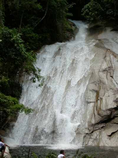
As for
the camping, picnic and Waterfall area, I must say that this is the
ultimate. Same class like Ceremrung & Berkelah destinations.
Very big falls - 4 of them. Gigantic pools and plenty of camping
space.
Very
far from modern civilization and perfectly pristine jungle settings.
In fact, we enjoyed the most in the early years when on the hike up,
the whole way was fully canopied. That hike itself was worth the
trouble we took.
My recommendation?
While
I did mention that there was none nor inadequate signage, it is
possible to hike to the Waterfall on your own. The first 3 kilometer
can be covered by any sedan. Very much unlike the
early years, the next part or 2 kilometers of the track are walking
through well maintained rubber plantations, The next 5 kilometers? The jungle
on the whole hills cleared and I think bananas are planted. It is
very exposed and not some trek in deep unknown jungle. The track
itself ex-logging trails are broad. Finally the last 3 kilometers is
fairly level on wide open track, but hot. Some arithmetic eh?
If you
do that, I am just wondering how much are you willing to carry? Full
packs!
For
those looking for escape. The tour operator provide just that.
Plenty of thrills and excitements, plus a chance to camp in a world
class environment.
Which
ever way you choose, be very careful when hiking up to the other few
Waterfalls. All within that 15 minutes distance. Climb is steep and
as the place is very humid, footings very wet too.
Click
here for more pictures. |