|
The place
Prominent signage of the
existence of a exotic Waterfall are now posted along the main road to
Kuala Kelawang. But once you get closer to the purported whereabouts,
the much needed signage are no where to be seen. Some concept I
cannot understand - the access road leading
to the waterfall was repaved. For two times now I seen it done - But
how to
get there to this road? Road signs stopped at the main road. Once inside the area
of Kampong Chennah, there was no mention of it at all. Forget
about these names calling. One thing never change -Kampong Esok. So
named, in the old days the road for 15 kilometers was so bad that once you enter, only "esok"
you can come out. So! - Look for Kampong Esok - the place is rubber
estate with 2 administrative buildings.
From the Asli village
to the waterfall, a short stretch of half
kilometers was not paved. [For fear that adventurous drivers coming
over the river bank may cause damages.] Then, the 3 kilometers track to the
waterfall was nicely completed - right up to the waterfall. A
year later in 2005, I could not drive my Suzuki Vitara through that
same road. It was that bad.
But I am sure that where the car cannot reach, it is not difficult to trek in
the rest of the way on foot. After
all, there were only a couple fairly short slopes.
This
Waterfall was a popular weekend destination for the 4X4 clubs. They have even
cleared a compound beside the river at the foot of the waterfall.
Erected permanent shed for overnight stay. Ever since the government had
put in proper road, that challenge to be there exclusively by "heavy
artillery" is lost.
For
visitors, there is nothing much to do. The downstream areas before
the waterfalls has quite a few spots for picnic or dipping. But at
the waterfall, nothing but scenic sights. All the trouble, you seen
one, you seen it all. Then why was this destination so nostalgic to
our group?
In the
early days before year 2000, this place is really "Ulu". Road of 15
kilometers paved by river rocks. Then we trekked 3 kilometers
through old logging trail along the Janda Baik-Jelebu Track to reach
the trail head to the waterfall. Then we climb 40 minutes down a
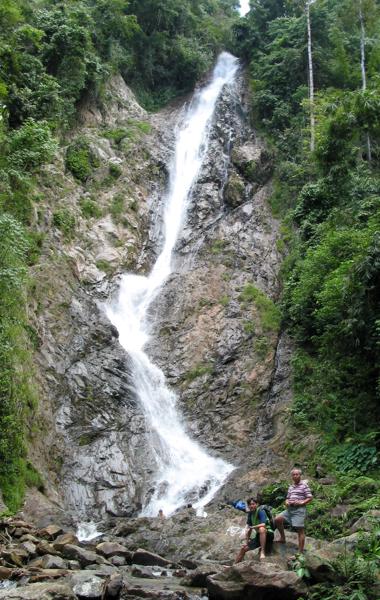
steep staircase in virgin jungle to unveil a beautiful tall white
Waterfall in the darkness of a tropical forest. Believe me the
feelings of achievements. Today, you look at the pictures on my
other page. Trees on the hills and valley entry side to the
waterfall is cleared. Yellow clay steep hill slopes and hot sun.
Rocky river and no swimming.
What is recommended
I
spent too much time describing the route to the waterfall. At the
waterfall itself, there were 2 ways of getting down the slope. Oh! you need to climb
down a steep slope of couple hundred feet to reach the bottom of the
waterfall. Looking at development, only one way is left, the easy
way at the open area.
This
place is definitely for the hard core adventurers. At one time, the
village committee do organize tours for visitors. If that services
is still available , city folks could join in the fun to experience the
Great Outdoor.
Since
this destination is a sort of "dead end" territory, I would strongly
recommend that you employ an Orang Asli guide from Kampong Esok.
Fees is nominal, but if you are prepared with tins of biscuits and
cigarettes, that is most welcome.
The
destination is strictly hiking, photography and fellowship. Without
the transport reaching the waterfall, you know that it is unwise to
bring more than your basic needs.
The
vibration brought about by the car going over river rock track for
two hours. I was
stuck once with the engine of my car going up in flame. I can tell
you that getting help or assistance to leave the village for the
main road was not easy.
|