6
kilometers from Serendah, Selangor State, Malaysia
|
Profile of Waterfall |
|
Water Source |
3 |
River |
|
Waterfall profile |
3 |
Cataract
Waterfalls |
|
Accessibility |
3 |
Car reach all part of banks |
|
Suitability for a picnic
destination |
|
Place for dipping |
3 |
Fair size pool, small patch for swimming |
|
Water quality |
1 |
Land clearing upstream |
|
Picnic area |
2 |
Plenty of space, filled with debrises |
How to get there ?
Six kilometers north of
Rawang is this ‘Cowboy’ town Serendah, where frequent travelers stop
for their meals. There is no special attraction here. Just a
convenient stop for travelers in the days before the NS Expressway was
built. Now it is a "dead" town. Something new though. The
new Serendah Golf course two kilometers north of town, do bring some
weekends visitors. Then, far deep inside the hills, there is a drug Rehabilitation Center
that most people do not care or wants to know about.
After the town, on the way
north, there are tracks that reached the low hills behind the town.
These tracks, originally made by logging company would link places like Ulu Yam Baharu and Sungei Tua.
Just 400 meters out of town,
there will be one set of traffic lights. At the traffic lights, turn
right into a housing estate. The internal road are arranged in a square
grid. Not such a big project,
the housing area of
The
housing estate
Taman Mawar, is modern Serendah with community Hall, school and
whose road were arranged in a grid gave wrong
impression that it is a "No-through-Road". Follow this residential
road just 400 meters and turn the left turn when the straight ahead
road seem to run into bushes.
The road then passes the settlement's Rukun Tetangga Post, schools and
community Halls. Then a "Y" junction.
You would see that view opens up to vast trait of waste land with
tall grasses, ex-mining ponds. At the Y –
junction, the right fork heading towards a housing estate Desa Anggerik..
See more pictures of this
destination. |
|
|
My Waterfall collection # 52/84
|
|
This
straight ahead road this time goes to the Rehabilitation Center. See
pictures of this junction in my next page. Drive past the
pond on your right. At this point you would see a level valley with hills as
background. Very close now.
Take this road and drive through the first small village, the whole
distance is about 2 kilometers. By the time you pass the center and
leaving the village area behind, the road is now replaced by a laterite
track. Though the place looks like having more than one tracks, keep to the track on the right.
Soon, you will meet up with
Serendah River. All in all this cross country stretch should
not be more than 500 meters. Cross the river and 200 meters upstream will
be the first and main Waterfall. The track would be going
uphill passing on top of this beautiful waterfall.
There were lots of activities in the area. The
"logging" trail [now in heavy use] runs besides the river. Plenty of
opportunities to see the other waterfalls and rapids along this road.
The place
The Serendah
Fall is not very tall, only 8.5 meters; the beauty lies in the
vertical drop. Khoo claimed that one can even walk behind the fall, it
is yet to be tried! The bottom of the fall is quickly filled with
sediments, which makes this large pool unsuitable for swimming in its
present state. Oh! Disaster coming. The authority built a structure
right at the water edge. The most scenic spot became the biggest
eye sore.
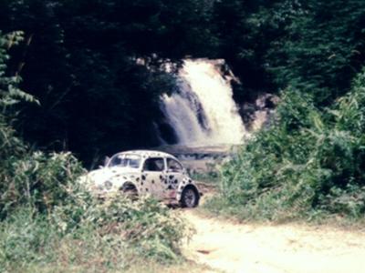
To illustrate this Waterfall, I have deliberately taken out one
photograph from my archives. It shows a beautiful jungle
settings of the past. The size of the waterfall in relation with the car.
Here you could also see that water is not really bluish, but
more of warm color. But the waterfall was much clearer at
that time.
Now there are a few hitches to this waterfall. People
responsible, wants to beautifies and promote this place. With
little understandings, they have turned a perfectly
beautiful place into a night mare. Next, the logging
activities is making a mess of the water quality. Not a
single day that you get to see river with clear water. Last
of all, the basin in the upstream, filled with
vegetable planting plots. Unlikely that the water could get
any clearer with them around. Worse still, the left over
fertilizers and filths from the farm are left to flow over
into the river, like a sewage.
My recommendation ?
What can I recommend? I can tell you 2 reasons why this page
is published. 1] In your quest to look for nice picnic areas
or to plan for exciting outings by seeking out waterfalls, you must have
heard that there is a beautiful waterfall in Serendah. Those
who made such comments had not seen the latest and argue
that it was very nice. Not knowing about the latest destruction. 2]
For nostalgic guy like me, who had seen paradise and now it
is lost, I cannot resist recording its final days - my
lovely Waterfall -once upon a time.
|
This page was first created on
25th December 1999 and was last updated on 25th March 2003 |