Canoe Adventures
[Home] [More Adventures] [Free Advice] [Links]
The Mud Pond Carry has it's origins in antiquity. The old corduroy, where intact, is a delightful sidewalk through an extensive, flat, and hushed spruce bog. Hundred foot pines tower through the spruce, their crowns flattened against the prevailing wind. Their distant sighing and whispering reminds us of the howling wind we left on the open waters of Lake Umbazooksus. An inland campsite, along the trail, sits beneath a few of these stately pines, and yields evidence of it's age, with the discarded wagon wheels, cast iron stove parts, and a tin can dump, slowly ebbing into the duff.
Other parts of the trail are hellish muck holes, boulder gardens, or gravel-bottomed stream-beds. At one point, the trail inexplicably veers off the corduroyed surface into calf-deep mud and water. Our portaging technique adapts to each section. Wet, split, raw hands untie lashings to lift the canoe off the cart either to carry or float.
The next day is National Trails Day, Saturday, June 6, 1998, and we awake to a gray sky, dark ragged rain clouds scudding past beneath, from the northwest. The clouds say rain, the wind says clearing. We are at the end of the Mud Pond Carry, a 1.5 mile trail connecting the Penobscot Riverway to the Allagash Riverway. It is also part of the Northern Forest Canoe Trail, along which there are many activities scheduled for this day. We celebrated with coffee and granola, made with freshly filtered water straight from the aptly named Mud Pond. Even though we are at the end, one last canoe and some of our gear lays trailside, waiting for us to fetch.
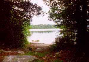
............ It all started about a week before. After surviving LL Beans, the special at Ruthie's Diner, and a flat tire, we arrived at the put-in alongside Chamberlain Bridge around 5:30. The local's advice at Ruthie's was: "Watch out for moose. The flies are driving them into the roads." We certainly found the blackflies, but the moose stayed hidden. A flurry of activity, and we had two canoes, one for me and one for Bob, in the water and packed for a long week's adventure. We shoved off, paddling through the Thorofare in relatively calm weather. All the campsites seem to have telling names, and we recognized Ledge Point long before we could see a site. We pulled in to a protected cove formed by the smooth, round upwelling of an ancient lava flow. Finally, we were on the water, away from vehicles, ready for eight days in the wilderness.
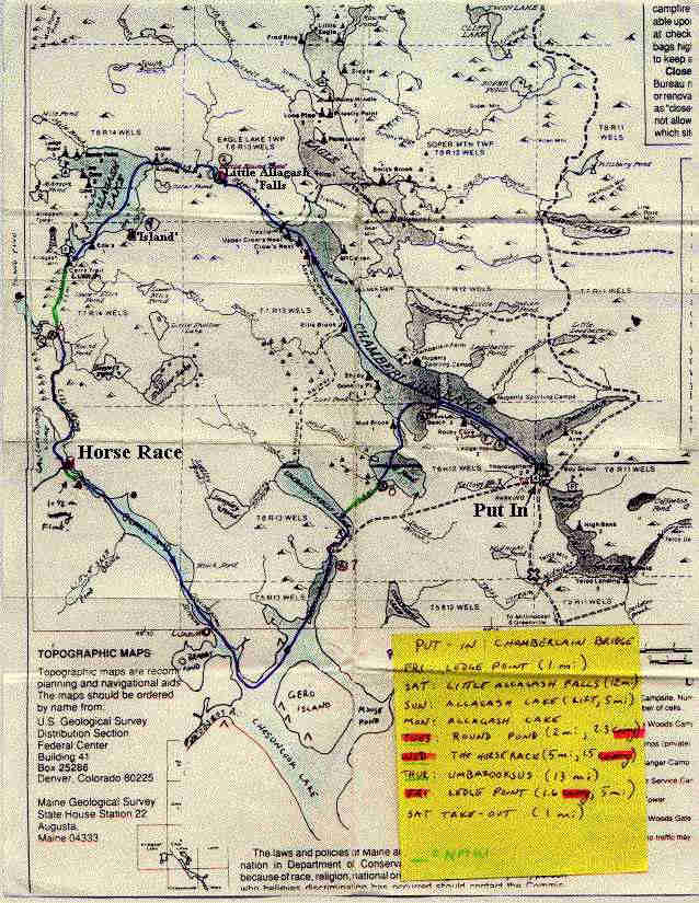
I photocopied the Allagash Wilderness Waterway map, available free (Bureau of Parks and Recreation, Maine Department of Conservation, State House Station 22, Augusta, ME 04333). Our route took us over the divide, and out of their jurisdiction, and so I had to append some of the map from another source. Two other good sources include DeLorme's Maine Gazetteer, and a single full-size map called Allagash and Saint John, also by DeLorme. I noticed each of these sources showed different campsites, and I added them all to my trip map.
The map shows the route pretty well, up Chamberlain Lake to the far northwest end, up Allagash Stream, with a 200 foot portage around Little Allagash Falls (very scenic, very remote), through Little Round Pond, the rest of Allagash Stream to Allagash Lake. In normal water, the trip upstream is supposed to be a fairly easy poling route. In the low water we had, there were too many rocks to maneuver and we ended up wading up much of the stream.
Allagash Lake is canoe-access only. Motor vehicles are not allowed within one mile of the lake. However, we had more "other people" problems here than anywhere else. When we finally gained the lake, a gale-force wind was blowing directly at us. We beached, and waded to the nearby campsite. It was full. It seems you can drive to Allagash Stream one mile above the lake and float down. Two parties did this, then proceeded to be blown across the lake to the campsite. Though motor boats are prohibited on the lake, the ranger saw fit to constantly buzz around in a motorized canoe, essentially defeating the purpose of the ban.
At the far south end of the lake, is a campsite named Carry Trail, and is the traditional ending of the Allagash Lake Carry. We took out, and followed the trail south. The first several hundred yards were obviously not an old Indian carry, but some park service employee's idea of a rugged good time. The trail went up and down, ignoring the terrain, through low wet areas and stream beds, not at all resembling an efficient, time-honored trail, groomed by thousands of years of foot traffic. Soon after the thrash through the boulders and mud, the foot path emptied out onto a fire road, and stuck to it the rest of the way to Round Pond. At one point we noticed a fire road heading back to the Forest Service Camp (I assume). Armed with a portage cart, as I was, this route would be far easier, though longer. One mile from the lake, there is a vehicle barrier, then the road is fairly well used. Reaching Round Pond, we had to cross a well-traveled gravel road to the nearest campsite.
Turning around, there is a sign advertising a carry service, hot showers, and a small general store. These services are provided by Loon Lodge on Round Pond. Though we were out of brandy and low on fuel, we avoided the lodge. Somehow it seemed evil, bringing many white men in pick-up trucks. Though we were disillusioned by the suburban feel, it might be a good jumping-off point for a less strenuous trip with the wife and kids. (Loon Lodge, PO Box 480, Millinocket, ME 04462). Who says you have to go to Tibet to hire porters.
Ciss Stream connects Round Pond to Caucomgomac Lake, both at the same elevation. The stream meanders without current through a large meadow filled with dri-ki. Ciss Stream seemed to possess a lot of the wildlife. This is where we saw many many immature bald eagles. We also saw our first moose of the trip along this stretch. I spied one on the right, up ahead, and pointed it out to Bob, who was in the lead. He paddled over and shouted, whereupon three big ones began a mad rush for the woods. We decided they must be sensitive to certain phrases like "Hey! Look at the friggin' moose!" Further down, there was a stump, that looked like a moose to me. I asked Bob and he said "Naw, it's a stump." I kept staring anyway, and eventually, it lifted a big moosey head, ears twiddling at it watched us go by. I tried the same trick again later, and stared real hard at a stump. I swear it almost moved, but in the end, it was still a stump. I'm sure it must appreciated the effort though, since life as a stump must be quite dull.
At the outlet into Caucomgomac, there is a tremendous fetch to the prevailing northwesterlies. A crossing past the outlet works to the official take-out would be a foolhardy proposition on this day. We opted for the lesser risk of taking out by the "Keep Out" sign and portaging across the lawn of somebody's fishing camp. A quarter mile down the road, across the dam, is the start of the 1-1/2 mile Horse Race Carry, and a couple of campsites.
We put in on the near side of the dam and ran the Horse Race. It was low water and once again we found ourselves bumping along, in and out of the boats, wading and paddling. About half way down, we encountered a huge wall of logs and trees, about 12 feet high, which seemed to block the entire river. A closer look revealed the river took a sharp left, hairpinned around a huge ledge outcrop, and returned to the same channel. We lifted over the ledge, but noticed a well-worn carry trail on the right. At the end of the shallow current, the carry trail from the dam enters from the right at a real nice campsite. This site didn't show up on any of the maps, and was quite possibly the nicest campsite we found.

From the Horse Race Campsite, it is flatwater all the way through Black Pond, Caucomgomac Stream, Chesuncook Lake, up Umbazooksus Stream to the bridge under a dirt road. Upon entering Chesuncook Lake, one connects with the Northern Forest Canoe Trail. To the southwest, one would ascend the Penobscot. We followed the trail northeast up Umbazooksus. After we passed under the bridge (a tight squeeze in low water, a carry at normal levels), we ascended the muddy meandering stream to the outlet of Umbazooksus Lake. It was tempting to ascend right up through the outlet works, but there was no headroom for a 12 foot pole, and the current had all the characteristics of a low-head dam.
On the banks of Umbazooksus Lake, we sat with our backs to the driven rain and tried to fathom the start of the Mud Pond Carry. Across the lake there was what looked like a grassy area, with a stand of mature white pine at the northern end of it. It dawned on me that my compass wasn't set for the declination of this area, and I could only guess at the right heading. This was a serious oversight, and caused a great deal of agony when we missed the take out by a couple hundred feet and had to battle through the gale force winds and waves to get there. We were right, though. the large pines did mark the trail, and some one had gone to the trouble of adding some orange and blue surveyors ribbon to the trailhead. The trail was nothing more than a mucky footpath that disappeared into the woods.
We started the carry at about ten-thirty AM on Friday, and finished about ten on Saturday. Seems a long time for a mile and a half, but we walked it several times up and back before we were done. We also cleared a dozen blown down trees out of the trail and moved some rocks and logs around where it crosses a logging road. The North Maine Woods folks would just as soon not have a historic trail through their private lands and dug water-filled settling basins in the trail, either side of their road. I can't blame either, after their experience with the legislature over the Allagash Wilderness Waterway. This little spat between the titans might also be the reason for the poor trail conditions, as the NMW may not want to give permission for a trail crew to work on it.
Mud Pond, a foot deep the whole way, sported stands of bulrushes in various spots across the pond. The 1970 AMC guide (the silver one, the one that recognizes more to canoeing than going downstream) described the outlet of Mud Pond: "The outlet of Mud Pond is very small. There is a dam with a gate here, which can be raised for a few minutes to fill the stream with water enough to float the canoe. Be sure to replace the gate so the next party will have water." Twenty eight years later, we were a bit skeptical of this routine, but still had hope. Bob arrived first, found the dam in ruins. Curiously, there was plenty of water to paddle. I caught up to him around the corner, where he stood on a beaver dam, carefully dismantling a small section. Just like the old days, we loosed enough water to float down to the lower flooded section. We left the chore of closing the dam to the beavers. We finished the day getting back to Chamberlain Bridge.
