
Moosehead Lake is Maine's largest lake. Located in the center of the state just southeast of Baxter State Park, the Moosehead Lake region has been a popular tourist resort area for over a century. The small communities of Greenville and Rockwood serve tens of thousands of visitors each year providing year-round recreation, shopping, restaurants, and accommodations.
The Moosehead Lake region is surrounded by mountains, many of which offer challenging and stimulating hikes and spectacular views. Here are some of the trails you may want to consider hiking when you visit the Moosehead Lake region.
If you have hiked in the area and have experiences or tales you would like to share or if you have pictures you would like to have on the Web, e-mail me. I will be posting stories of your experiences as this Web develops.
Big Squaw Mountain stands 3,196 feet above sea level, over 2,000 feet above Moosehead Lake. Located 6 miles west of Greenville, Big Squaw was the site of Maine's first fire tower offering views from Mount Katahdin to the northeast to Bigelow to the southwest, from the Canadian border to the northwest nearly to the coast to the southeast. Big Squaw overlooks the entire 40 mile length of Moosehead Lake.
Big Squaw also hosts Big Squaw Mountain Ski Area on its north slopes with a chairlift that runs not only during ski season, but also during the summer season for sightseeing rides. In the summer, sightseers can climb from the top of the chairlift ride to the fire tower at the mountain's peak.
The southeast slope hosts the old fire ranger's trail, a moderately steep but very rewarding trail. The trailhead is on a dirt road which branches off routs 6 and 15 across from the Squaw Brook campsite and the Maine Forest Service office. Parking is provided at the trailhead.
Mount Kineo stands in the center of Moosehead Lake on a peninsula. The Mount Kineo peninsula was the home of a very large resort hotel in Moosehead's steamboat heyday. Now hosting a nine hole golf course and various other services, the peninsula and the mountain offer visitors breathtaking views.
The Mount Kineo peninsula, although served by private gated roads, is generally accessed by boat from Rockwood midway up Moosehead Lake on the western shore. A public boat launch at Rockwood offers parking while scheduled shuttles run during the summer season from the Rockwood docks to the Mount Kineo docks. Plan ahead for this trip if you wish to use these shuttles.
If you are using your own boat or canoe to reach Mount Kineo, be advised that Moosehead Lake is known for unpredictable winds and waves and what was an easy trip to the mountain can become a challenging trip back.
Mount Kineo's eastern slope rises nearly vertically 700 feet above the lake. If you are in a boat, don't miss this spectacular scene. Travel around the northern shore of the peninsula, follow the shoreline east, and drop back south into the cove. From here, you can approach the awesome base of this cliff. While you are here, don't miss the sand beach that lines the narrow link of the peninsula to the mainland.
Several trails lead to the peak of the mountain. All trails are accessible from the golf course and the Kineo docks. There is a tower at the top of the mountain, the restored remains of a Maine Forest Service fire tower. From this tower, hikers see a spectacular panoramic view of the entire lake and the surrounding mountains. From the hills around Greenville to the shoreline of Northeast Cary, and from the ski slopes of Big Squaw Mountain to the steep slopes of the Spencer Mountains and beyond to Mount Katahdin, this 1,789 foot mountain is a truly rewarding experience.
If you are the daring type, hike east from the fire tower to the top of the cliff. I had to approach this on my hands and knees I was so petrified, and I am not easily shaken by heights! Look nearly straight down over 700 feet into one of Moosehead's deepest spots. Keep your children safely away from this precipice.
Lying just west of Greenville, Little Squaw Mountain offers moderate hiking over a set of trails on Maine public lands recently blazed by the state. Hikers have two possible access points to these trails.
The easiest access to Little Squaw is from the parking area at the Greenwood Motel just west of Greenville on routes 6 and 15. The trail begins at the motel and follows the gradual slope of the ridge from this point nearly to the mountain's peak. Vistas along the trail offer outlooks both to the north up the lake and to the east towards Greenville.
The surprise of this hike is that there is no vista from the tree-covered peak. The savvy hiker will make her/his way from the state trail to the top of the ledge that overlooks Greenville. I call this the eagle's nest because of the comfortable little pocket in the rock protected from the prevailing northwest wind that looks directly down on Pritham Avenue in Greenville giving a birds-eye view of the activities of this town. Watch while seaplanes take off and land on Moosehead and land planes fly in and out of the Greenville airport. Watch boats leave their wakes on the lake, and the Katahdin as it plods slowly up the lake and back. Watch trucks that travel through this town loaded with logs or chip trucks unloading at the Greenville Steam power plant. You may even see a train snake its way down the Canadian Atlantic Railway. Don't forget to bring your binoculars, camera, and a snack.
The flip-side of this hike is a trail system to the west of the peak. Although you can continue the hike from the Greenwood Motel down the west slope of the mountain, these trails are best approached by driving in beyond the Big Squaw Mountain ranger trailhead, bearing to the left as the road forks, and driving to the parking area. A moderately short hike from the parking area brings you to the campsites on Big Squaw Pond. The trail continues to campsites on Little Squaw Pond.
A very cleverly laid out trail encircles Little Squaw Pond following the rocky ridge along the south shore of this pond. Several outlooks offer spectacular vistas of this area. This loop trail ties into the trail from the Greenwood Motel.
If you are into outdoor camping and enjoy being in the woods, but still like to be near civilization and your car, consider this spot in your vacation plans.
Big Spencer Mountain lies east of Spencer Bay on Moosehead Lake. On its 3,230 foot peak is one of the last manned Maine Forest Service fire towers. The rounded profiles of Big Spencer Mountain and its near-twin Little Spencer Mountain are landmarks of the Moosehead Lake region visible not only from the Greenville side (south of the mountains) but also from Rockwood, most parts of Moosehead Lake, Mount Katahdin, and many points in the woods north of Moosehead.
Big Spencer Mountain also overlooks Ragged Lake and beautiful Lobster Lake, home of some of the best campsites in Maine.
To access Big Spencer Mountain, drive north from Greenville following the east shore of Moosehead. Watch for moose and drive carefully. The moose love to hang out along the sides of this road. The road is paved to Kokadjo, a small outpost on First Roach Pond about halfway up Moosehead Lake. The road beyond Kokadjo is dirt and is owned and maintained by paper companies. You will be charged a fee at the Sias Hill gate. Ask the gatekeeper about road conditions to the base of the Big Spencer Mountain trail. Look carefully for moose on the top and north side of this hill.
The trail is steep and direct. About midway up you will reach the ranger cabin which overlooks Ragged Lake. The fire tower is on the eastern edge of Big Spencer's long peak. Much of the view to the west is blocked but the view north and east more than make up for it as the mountain overlooks much flatter terrain to the north and the Mount Katahdin region to the east. This can be a strenuous hike for those not accustomed to mountain day-hiking.
East of Greenville on logging roads usually maintained passable for most vehicles is a mountain known not for its hiking trails but rather for its place in history. On a cold blustery January day in 1963, a US Air Force B-52 bomber engaged on a training mission in the early development of low-level radar avoidance was caught in heavy turbulence just east of Elephant Mountain. Witnesses in Brownville saw this plane pass overhead at about 3:00 PM just before a heavy crosswind violently ripped the vertical stabilizer from the plane.
Several crewmembers ejected from the plane but by the time the wreckage was located and rescue teams arrived, only two of the nine men on board survived. One of the survivors was able to continue his aviation career. The other lost both legs in what may be the strangest story ever told in aviation history. Just as the doomed bomber was clearing the top of Elephant Mountain's northern flank, this man ejected into the harsh winter cold and before his parachute was even able to open tumbled through the trees to the snow-covered ground. Miraculously he survived to tell his tale and years after the crash even returned to the site for commemorative services.
For years the crash site remained well out of reach of salvage crews and the eight jet engines, huge but torn tires still on their broken landing struts, the one remaining section of the fuselage where the tail-gunner once sat, and the thousands of torn fragments of the long wings and giant fuselage lay strewn for several hundred yards on the western slope of the mountain. Several salvage attempts failed over the years as first brush and then trees grew out of the crash site.
The Elephant Mountain area had been heavily logged several years prior to the crash. The strewn wreckage at the crash site crossed one of the logging roads that traversed the western side of the mountain. For many years hikers parked as near to North Brook as the aging roads allowed and hiked the muddy logging road to the site. Several years after the crash the site was almost forgotten and by 1970 it was difficult to stay on the right trail to find the plane. But the logging road on which the plane lay continued over the mountain and a hiking trail to Baker Pond developed following this old road. Word spread once again of the huge wreck and once again the story of that cold blustery day came to light.
By 1990 a new set of logging roads were built and one of these roads came within a few hundred yards of the wreckage. This sparked a renewed effort to salvage the metal parts remaining after nearly 30 years. Skidders dragged the heavy jet engines to the road and trucks hauled them away. Greenville residents, recognizing that this public interest spot was about to vanish acted quickly to have the salvage stopped and were successful in bringing public attention to this historic site. As a result, most of the original wreckage remains where it first fell and footpaths meander from fragment to fragment. In summer adults and children, men, women, boys, and girls explore the wreckage pausing at the markers to ponder the fate of the men who lost their lives in the tragedy of that wreck. A new slate monument in recognition of those who perished and those who survived the crash now rests against the tail-gunner's section of the fuselage, the only part of the fuselage to remain intact in the crash.
There are two ways to reach this site from Greenville. One is to follow Scammon road to the CCC (Civilian Conservation Corps) Road and follow the north shore of Lower and Upper Wilson Ponds to the mountain. This is the shorter route but the roads tend to be rougher in spots. The other approach is to take the Lilly Bay Road from Greenville to Beaver Cove and head east along the north side of Prong Pond till you meet the CCC Road, then follow that road to Elephant. Once you leave the Lilly Bay Road, drive slowly and watch for traffic on these narrow winding dirt logging roads.
Rough mileages along the second route are:
| Greenville to Prong Pond | 7 miles |
| Lilly Bay Road to CCC Road | 4 miles |
| North Brook | 1 1/2 mile |
| North Brook to B-52 | 1 mile |
| Total | 13 1/2 miles |
Note: There was a change in the road that was made since the year 2000. These directions reflect that change. A new bridge was built across North Brook to avoid a steep hill west of the stream. The new route takes you from the intersection where the crossroad from Prong Pond meets the CCC Road. A kiosk has been built at that intersection. From there the old CCC Road continues east to North Brook. Shortly after crossing the bridge, the road meets a T intersection. Take a left at that T and you soon intersect with the road that used to cross North Brook.
At that point, the only road open begins a gradual climb to the northeast paralleling the base of Elephant Mountain. Drive around several large clearcuts working your way back to the right and up to the side of the mountain. These clearcuts are examples of modern tree harvesting where nearly all of the trees and tops are taken. That which is of no value for lumber, paper, or particle board is chipped for the "biomass" energy plants. Some of these areas have been replanted while others were allowed to seed in naturally.
Look for trail markers and a small parking area on the upper side of the dirt road that meanders north and south along the western slope of the mountain. The trail is clearly marked and the wreckage lies within a few hundred yards of the road. There are two short trails leading from the road to the wreckage.
My first visit to this crash site was in May of 1963. Air Force personnel were still guarding the wreckage and the whole area wreaked with the smell of jet fuel. Shortly after that, large amounts of yellow paint were spread on the larger sections of wreckage and that paint is still visible today. I once heard that this yellow paint marked the wreckage as open to salvage.
On my first visit of 1998, I found the new slate marker resting against the tail-gunner's section of the plane. I found what I assume to be one of the horizontal stabilizers and three of the landing gear struts with tires still on the wheels. I found what appeared to be a section of the bomb bay and a section of fuselage with two window frames in it. At the very top (western end) of the wreckage is a shallow trench and at the top of that trench was what appeared to me to be the fiberglass wingtip from the right wing. Thousands of fragments remain strewn along a path that fans out down the hill from the trench where the plane first impacted.
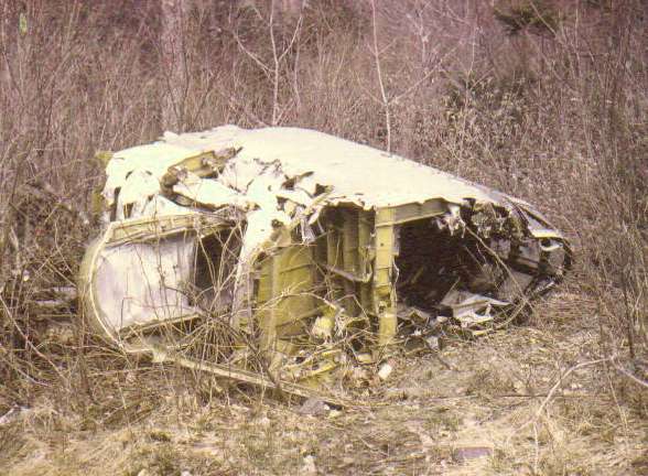
Tailgunner's section of B-52 on Elephant Mountain in Maine
Crashed while flying low-level training mission on January 23, 1963
Picture taken in May 1968
Rumor has it that the vertical stabilizer of this plane lies on the east side of the mountain. I have heard several stories of people finding ejection seats on the mountain betweeen where the vertical stabilizer broke off and the actual crash site. I would assume that those seats are no longer out on the mountain. To the best of my knowledge, no trail tracks back along the plane's flight path from the crash site to the site of that vertical stabilizer.
This climb is for the more adventurous among you day-hikers for two reasons. First, there is no trail to Elephant Mountain's eye. Secondly, once you reach the rock slide beneath the eye, you realize the marks of recent rock slides and begin to ponder the danger you are in should more rock break from this ledge. But the view to the west from this rock slide is impressive and frankly, I find the excitement of being beneath the ledge exhilarating. Besides, once you have found the spot, you can tell everyone that you have been to the "eye of the elephant."
To reach the eye, follow the roads from Greenville to North Brook just as if you were going to the B-52 wreck (above) but bear right after crossing North Brook. Follow south along this road until just before the road crosses the South Brook bridge. Backtrack from this second bridge looking for the old road to Horseshoe Pond and begin the hike there. While the hike into Horseshoe is a good one (Horseshoe is a good trout pond for flyfishing), you will need to leave the trail when it reaches the ridge that represents the Elephant's trunk. Hike north up the west side of this ridge and begin the search for the rock slide beneath the eye.
I always miss this rock slide and meander aimlessly for awhile before coming to my senses and stumbling upon this open slide. Too far south or too high up and the mountain becomes steep while too far down it is mostly hardwoods. Once you locate the slide, climb up the boulders to the bottom of the ledge that forms the eye if you dare. I once even climbed to the left of the eye and up above that ledge for a better view, but the climb is steep and dangerous and I would not recommend it.
Getting down is easier than getting up. Simply work your way down (southwest) the ridge till you intersect the road to Horseshoe Pond. Remember that when you hike anywhere there are no trails, you should tell someone where you are going and when you expect to return. You should also carry a compass and know how to use it to get back out of the woods you are exploring.
Return to Table of Contents
Return to I Like Maine Home Page
Last Updated on February 27, 2005 by Bill Walden