|
|
|
|
Gunung Tahan (Mount Tahan). One of the
famous mountains of West Malaysia is the Gunung Tahan, the highest peak in
Peninsular Malaysia. Standing at 2191m, it is a mountain worthy of its name.
Tahan is a Malay word which means to endure, suffer, hardship and pain, and that
is what climbers had to go through to enjoy its peak. I suppose apart from the
scenery that lure people to climb Mt. Tahan, it is the satisfaction and
accomplishment of reaching the peak, and coming back, that drives people to it.
For those who are looking for a different kind of challenge in life, or to prove
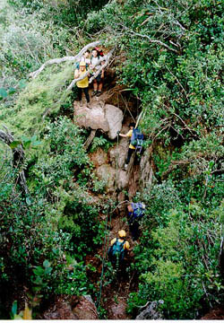
something, then look no further. I can recommend Mt Tahan any time. The peak of Mt. Tahan can be approached from two sides. The first one is from Merapoh, on the eastside of the mountain. It will take you 2 days and the track is mostly steep. Or you could decide on the second approach, the more scenic route, through Pahang National Park, which ideally would take about 5 days climbing and 4 days tracking down. A three hour boat ride is one of the best way to reach Pahang National Park. Most of the people from abroad which I met during my trip to Mt. Tahan were actually visiting the park, but later decide to go for the climb of their life. It is a 55 kilometre of tracking through the lush forest to reach the top. During the 9 days expedition, expect to climb a number of mountains and cross a few river. The mountains that have to be scaled are Gunung Rajah (576m), Gunung Pankin (1463m), Gunung Tangga 15, 1539m, (Mountain of 15 stairs) and Gunung Gedong (1830m) before finally reaching Gunung Tahan at 2187m. The river crossing is another experience by itself. During a dry season, the water is about knee deep. But with the strong current, slippery river stone and heavy backpacks, it presents a quite challenging combination. For those who are unfortunate enough to climbed during a rainy day the water level can rise drastically to about 80cm, and you have to wait for it to go back down. This sometimes will take the whole day. Having to reach the top of Gunung Tahan was a test to those who embarked, both mentally and physically. I had mixed feeling when I reached the peak - Happy, ecstatic, satisfied, vigorous and thankful. Click Here for chronology and pictures from the Mt Tahan expedition. |
|
|
|
| [Home] | [Next] |
Copyright @ 2000, Jefry
Rizal. All Rights Reserved
Best viewed using IE5.0 at 800x600
with 24-bit colors
This page is hosted by ![]() Free Home Page
Free Home Page