Gila Wilderness Area, New Mexico--Going
Wild in America’s First Wilderness
((2,793 words, Adv. Travel; 3 cap))
Amber Borowski
 Let’s
get something straight: I do not speak Spanish. My linguistic capacities are
limited to hola, taco and tamale. As
an immigrant from above the northern border, I am much better versed in phrases
like sub-zero, cross-checking and crummy Canadian dollar. Even with this
disclaimer, I was chagrinned that I slaughtered the pronunciation of Gila
Wilderness when I pitched this story to my editor. How could I have known that
‘g’ in Gila is actually pronounced ‘h?’
Or that one of its mountain ranges, Mogollon, does not sound like
Mongolia, but more like “Mug-yeeon.”
Let’s
get something straight: I do not speak Spanish. My linguistic capacities are
limited to hola, taco and tamale. As
an immigrant from above the northern border, I am much better versed in phrases
like sub-zero, cross-checking and crummy Canadian dollar. Even with this
disclaimer, I was chagrinned that I slaughtered the pronunciation of Gila
Wilderness when I pitched this story to my editor. How could I have known that
‘g’ in Gila is actually pronounced ‘h?’
Or that one of its mountain ranges, Mogollon, does not sound like
Mongolia, but more like “Mug-yeeon.”
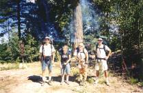
Prior to setting out to the Gila Wilderness, I hooked
up with three native Arizonans—Ray, Joseph and Karleen—in what I call the
fiery furnace (most people just refer to it as “Phoenix in July”).
I was relieved when we left that sweltering city behind and ascended into
New Mexico’s canyon-gutted, mesa-muscled and unpronounceable high country.
Established in 1924 as the first forest wilderness
preserve in the world, the Gila Wilderness Area comprises over half a million
acres covering more than 1,000 square miles in southwestern New Mexico.
Created at the urging of the great conservation pioneer, Aldo Leopold, it
is a part of the Gila National Forest which contains 3.3 million acres over four
tree-covered mountain ranges: the Mogollons, Diablos, Tularosas and the Black
Range. Nearly one-fourth of that acreage consists of the Gila, Aldo
Leopold and Blue Range Wildernesses. More
than 1,500 miles of hiking trails lace the forest, ranging from a base elevation
of 4,500 feet in the high desert to peaks that almost touch 11,000 feet.
Biotic zones from desert to alpine are represented, and the Continental
Divide snakes 170 miles across the spine of the national forest.
This was my first time in New Mexico and I had great
expectations for our four-day backpacking trip. I hoped to discover a place of
wild silence that remained as unspoiled as the day it was designated; a land
free from modern artifacts, where I could seek solitude on pure, star-bright
nights. I was not disappointed.
 We
decided to conquer the Mogollons, which include the wilderness area’s highest
peaks. We would do a strenuous
lollypop-shaped route through a variety of terrain, starting at Sandy Point
Trailhead on Bursum Road and continue along the Crest Trail.
Stops along the way would include Hummingbird Saddle and side-trips to
two of the range’s highest peaks: Whitewater Baldy, 10,895 feet and Mogollon
Baldy, 10,770 feet. We would then
follow the Holt-Apache Trail, camp at the Spruce Creek Saddle and then continue
down to Redstone Park. Our final
day, we planned to backpack out to the Redstone Park Trailhead and hitch a ride
back to our car. We calculated the route to be approximately 30 miles, plus some
minor side- trips.
We
decided to conquer the Mogollons, which include the wilderness area’s highest
peaks. We would do a strenuous
lollypop-shaped route through a variety of terrain, starting at Sandy Point
Trailhead on Bursum Road and continue along the Crest Trail.
Stops along the way would include Hummingbird Saddle and side-trips to
two of the range’s highest peaks: Whitewater Baldy, 10,895 feet and Mogollon
Baldy, 10,770 feet. We would then
follow the Holt-Apache Trail, camp at the Spruce Creek Saddle and then continue
down to Redstone Park. Our final
day, we planned to backpack out to the Redstone Park Trailhead and hitch a ride
back to our car. We calculated the route to be approximately 30 miles, plus some
minor side- trips.
The drive to the Gila Wilderness along Highway 180
evolved from tough vegetation that seemed to cling to the arid land for dear
life, to the verdant woods of the Gila National Forest. We passed through
Glenwood, a quaint ranching community that hosts a few restaurants, a bar, and
the Catwalk, a 2.5-mile walkway anchored to a rock wall above the rushing waters
of Whitewater Creek. A few miles later, we turned and followed a steep road,
winding sharply into the densely forested mountains past the ghost of
once-booming Mogollon. In 1890,
Mogollon was a bustling mining camp that boasted 20 saloons and 2,000 residents.
Today, it squeaks out a gourd gallery, museum, and a series of
dilapidated cars and houses.
Climbing Whitewater Baldy’s Rapids
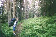 I was
relieved to see only a few cars at the Sandy Point Trailhead.
We were soon on the trail, climbing through the vitality of these
green-cloaked mountains. Our pace
was brisk up the moderately sloped pitch. Impenetrable
vegetation quashed any hope of expansive views.
Besides three hikers from Texas, we were alone.
I was
relieved to see only a few cars at the Sandy Point Trailhead.
We were soon on the trail, climbing through the vitality of these
green-cloaked mountains. Our pace
was brisk up the moderately sloped pitch. Impenetrable
vegetation quashed any hope of expansive views.
Besides three hikers from Texas, we were alone.
Less than an hour after we started, Ray wheezed that he
felt he was going to black out. We
suspected he had food poisoning or the flu, and we stopped to rest. Joseph, who
packed everything including the kitchen sink (or at least the medicine cabinet),
produced some charcoal tablets that he assured would help Ray unclog his system.
We
eventually continued up a steady pitch for 5.2 miles and stopped at Hummingbird
Saddle, where we ate a late lunch amidst a patchwork of mellow greens.
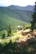
The wilderness area’s highest peak, Whitewater Baldy, loomed behind us
like a 10,892-foot monolithic sentry. After lunch, we did a side-trip up its
steep, crudely etched trail. “Baldy” is a misnomer—there isn’t anything
bald about this mountain and its thick woodlands blocked our view from the
summit. We found an altar of rocks that marked the highest point, and
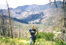
then hiked down a rock-strewn ledge. Finally,
we were afforded our first, clear view of the wilderness area as we were brought
face to face with our own insignificance.
After descending, we filled our water in a spring 1,000
feet from Hummingbird Saddle, and then followed the trail around the east side
of Whitewater Baldy through a dense spruce and fir forest.
A few miles later, we reached the Holt-Apache Trail junction, low on
water and energy. We debated continuing another mile down the trail toward
Mogollon Baldy where our topographical map promised water at Hobo Spring.
Exhausted, we finally opted to stay just above the Holt-Apache trail
junction and get water on the way to our Mogollon Baldy side-trip the next
morning. Ray still felt
queasy, so Joseph prescribed garlic tablets. The mosquitoes weren’t the only
ones who avoided poor Ray that night.
We ate dinner under an almost phony, deep-blue sky that
looked like an acrylic pretension by some meticulous pop artist. Soon, the
ebbing sun capitulated to an ebony sky. Karleen and Joseph started a fire as the
full moon poked through the trees. By
moon and fire, we read to one another aloud and watched the flames slowly
transform to blazing coals. Occasionally,
Joseph would lean over and breathe life into the embers, resurrecting the
flames. Karleen christened him
Dragon Breath. I gave Ray the same
moniker, for different reasons.
Giving and Taking at Mogollon Baldy
It was a warm night for 9,000 feet.
I awoke around 6:30 a.m. and lounged around camp while Ray slept in.
I put in my contact lenses, but soon realized I was half-blind—one of
my lenses had not made it to my eye. Panicked,
I searched the tent; wandering around the wilderness half-blind was not a
promising prospect. Just when I was
about to give up, I found it—plastered to my tube of toothpaste. It was a typical start to a day in the life of Amber Borowski:
one of blindness and confusion.
After Ray awoke, we grabbed our daypacks and started for
Mogollon Baldy, anticipating finding water along the trail.
We didn’t. Hobo Springs is
another misnomer in the Gila—Hobo Drip is more befitting.
We decided to try our luck at Little Hobo Spring, another mile down the
trail, which proved more like Little Hobo Puddle—there was not even a drip to
be found.
 We had
only one purifier between us, and it was attached as an in-line filter to
Ray’s CamelBak. It quickly became
clogged when we tried to draw water from Little Hobo’s murky puddle.
We had no choice but to continue up Mogollon Baldy with minimal
hydration. GPS in hand, Ray assured us that the summit was only a few miles
away, “give or take.” With Ray,
I have learned that the “give” could mean about one mile, and the “take”
around 20. Our side-trip turned out
to be about 10 miles roundtrip (give or take, of course…)
We had
only one purifier between us, and it was attached as an in-line filter to
Ray’s CamelBak. It quickly became
clogged when we tried to draw water from Little Hobo’s murky puddle.
We had no choice but to continue up Mogollon Baldy with minimal
hydration. GPS in hand, Ray assured us that the summit was only a few miles
away, “give or take.” With Ray,
I have learned that the “give” could mean about one mile, and the “take”
around 20. Our side-trip turned out
to be about 10 miles roundtrip (give or take, of course…)
Thankfully, the temperatures were cool and the pitch
reasonable. We hiked through a
green coverlet of rich, dense riparian habitats--by far my favorite stretch of
the entire trip. I felt more like I was on the coast of Washington than in the
heart of southwestern New Mexico. We
wound through beautiful aspen and fern groves. Kaleidoscopic butterflies took
wing along the path. Hummingbirds nestled in our sheltered aviary and I listened
as woodpeckers befriended the cottonwoods.
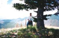
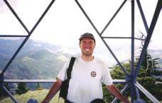
 Our
experience atop 10,770-foot Mogollon Baldy was much more rewarding than
Whitewater Baldy. Upon the summit,
we found a historic guard cabin and lookout station where Forest Service
personnel reside May - August. We received a tour of the tower from Sarah
Irving, who has spent every summer here for 20 years. She has seen many tides of
destruction, including a forest fire that burned over 15,000 acres in 1996.
Our
experience atop 10,770-foot Mogollon Baldy was much more rewarding than
Whitewater Baldy. Upon the summit,
we found a historic guard cabin and lookout station where Forest Service
personnel reside May - August. We received a tour of the tower from Sarah
Irving, who has spent every summer here for 20 years. She has seen many tides of
destruction, including a forest fire that burned over 15,000 acres in 1996.
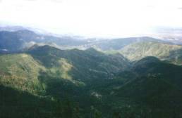
Following our tour, I settled on the grass near a
geologic marker, not knowing exactly what to do or think or feel as I soaked up
the thin air, smells and temperature. I
filed the expansive 360-degree view into my memory bank. At the crest of the
desert, the southern horizon exploded into a mind-boggling display of mountains
and ridgelines that drifted in and out of a powder-blue haze.
To the distant west, Arizona’s White Mountains cut across the sky as if
drawn with a straightedge. A plane
scratched patterns in the cerulean sky above it all. The plane eventually
disappeared; the celestial sketches remained.
Spruce Creek Saddle and the Bartering Backpacker
We reluctantly started the 5-mile trek back to base camp.
We were fortunate to find a father and son at Hobo Spring who graciously
purified water for our parched packs. Once
back at camp, we packed our gear and followed the Apache-Holt trail until we
reached a sign pointing us 1.75 miles to Spruce Creek Saddle.
We detoured 0.1 mile down the Windy Gap trail and explored the abandoned
Apache Cabin. Call me crazy, but the lure of squeaky spring beds, a wood stove,
empty whisky bottle and rodent droppings wasn’t much temptation to stay long.
We continued along the Holt-Apache Trail and soon reached
Black Mountain Spring’s flowing cascade.
After replenishing our water supply we continued 0.7 mile down a trail
that provided open views of upper Whitewater Baldy
 before
our descent to Spruce Creek Saddle at 9,620 feet.
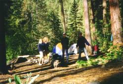
We pitched camp in this grassy aspen-ringed flat and all seemed
perfect--until dinner. While
placing my ThermaRest outside I noticed an army of gnats everywhere. We combated
them by lathering ourselves in Joseph’s bug spray.
before
our descent to Spruce Creek Saddle at 9,620 feet.
We pitched camp in this grassy aspen-ringed flat and all seemed
perfect--until dinner. While
placing my ThermaRest outside I noticed an army of gnats everywhere. We combated
them by lathering ourselves in Joseph’s bug spray.
As it turned out, water was not our only supply stress that
day. At group confessional around the fire that night, Karleen, Ray and I
realized our personal stashes of toilet paper were down to a bare minimum, and
we still had two nights left on the trail.
We all turned to Medicine Man, and, sure enough, he was amply supplied.
Now, Joseph could have generously surrendered his coveted stash, but he
instead seized the opportunity to do some backcountry bargaining. The deal:
one packet of tissue for a foot rub.
I obligingly gave in; desperate times call for desperate measures.
Campfire discussions turned deep that night but my
fatigued mind was about as focused as the nebulous clouds. I fell asleep immediately after my head hit the pillow until
a penetrating light woke me at 2:30 a.m. Confused,
I stumbled out of the tent and realized the luminescence of the full moon had
set our meadow aflame. No longer tired, I explored. No wind blew, but the leaves
of the cottonwoods were wavering on their boughs, and a mysterious, swollen
atmospheric pressure popped them loose, as if by magic.
Made almost dizzy by the atmosphere’s seductive
passivity, I glanced around for evidence of a single invisible current.
I felt and heard nothing. No
crickets, no birds--only a deafening silence. I do not know how long I watched
the surreal light dance across the meadow; I do know that the Gila Wilderness
Area seeped into my soul that enchanted evening and made an everlasting imprint.
The “Cap”tivating Redstone Park
Perhaps due to my late night out on the range, I
started feeling nauseous and queasy after breakfast. When the nausea didn’t
pass, Joseph graciously handed over the last of his charcoal tablets—without
any kind of stipulation whatsoever. I
must have looked pretty pathetic.
I was grateful we were only 4 miles from Redstone
Park, our destination for the day. The
route ascended sharply above Spruce Creek Saddle.
We crawled over a tree graveyard of
 umpteen
fallen trees that blocked the path. Once
at the apex of the trail, we made a steep descent a couple of thousand feet
before arriving at Redstone Park.
umpteen
fallen trees that blocked the path. Once
at the apex of the trail, we made a steep descent a couple of thousand feet
before arriving at Redstone Park.
Redstone Park, with its churning and flirtatious
Whitewater Creek, was the oasis of our trip.
I was the first to throw myself into its waters and the others quickly
followed. We explored and relaxed
on sandstone rocks reminiscent of those in Zion National Park. We watched the
water and sun pour through the chasm like silky syrup.
Just when I thought it couldn’t get any better, Karleen generously
offered me her soap and shampoo. This
had to be paradise.
After a time, a dozen shades of gray appeared over
our heads and a funny thunder, muttering inarticulately, puttered around in the
sky. The rain lasted only a few
minutes, but was enough to motivate us to set up camp and nap in our tents.
We spent a few hours in the late afternoon hiking through the ribbon-like
creek. Joseph and Ray treated it
like a giant obstacle course and leapt from shore-to-shore.
Karleen and I sloshed through it. I had spent two days craving water; why
avoid it now?
That night, my unsettled stomach rejected my bland
soup and I dumped my dinner after a few slurps. I decided to purify my water for
the hike out the next day so I grabbed Ray’s CamelBak and filter.
After filling my bottles, I went down to the creek to refill the bladder,
after which I reached for the cap but it was nowhere to be found.
I scanned the rock and reasoned that I must have left it by the tree
where Ray had hung the pack. I was wrong. And then the magnitude of my
predicament set in--I had lost the sealant on our only reliable water source.
I then did what I do best in moments of crisis: I freaked out.
I raced back down to the creek and did a mad,
frenzied sweep along its banks. Joseph leisurely came down
and in great amusement, he called out to me, “Uhh, what do you think
you’re doing?” A valid
question, considering this was my first sign of real animation since I became
ill that morning. I let him in on
my quandary and he scoured the other side of the bank.
I eventually gave up but then Joseph called over to me, “Amber, look
over here!” And with that, we
reached down and swooped up the cap from a shallow pool. Gratitude followed shock as I jubilantly screeched out, “I
OWE you!” That was my second
mistake (the first was, of course, losing the cap).
Mr. Backcountry Barterer devilishly smiled at me and said, “OK,
lunch?” First the charcoal
tablets, then the toilet paper, and now lunch; I resigned myself to being
forever indebted to him.
A Final Glimpse into the Wild
 I arose
early the next morning. I felt better after a good night’s sleep and wistfully
realized I only had a few hours left in the Gila Wilderness.
I walked down to the creek. A
morning dew fog hung subtly above the ground; I was peering into a fairytale.
The morning sun slowly kindled the upper canyon walls, reminding me of the high,
bright opulence of a castle.
I arose
early the next morning. I felt better after a good night’s sleep and wistfully
realized I only had a few hours left in the Gila Wilderness.
I walked down to the creek. A
morning dew fog hung subtly above the ground; I was peering into a fairytale.
The morning sun slowly kindled the upper canyon walls, reminding me of the high,
bright opulence of a castle.
We were on the trail for our final parking lot push by 8:30
a.m. Ray assured us the 4.7-mile
hike out had an elevation gain of only 700 feet—a piece of cake.
What Mr. Give or Take’s GPS failed to note is this was the net
elevation gain. Most of the hike
was actually a straight shot up, followed by a short yet steep drop to the
parking area.
Despite the strenuous pitch, our final few hours in
the Gila Wilderness Area were unforgettable.
Grouse Mountain towered over us. We
reverently watched an owl perched on a branch, mere feet away from the trail.
The silver-skinned aspen trees seemed to wave us toward the forest’s
slanting sunlight. We stopped
periodically for pictures, hoping to record a glimpse of the Gila Wilderness’
magic. But it evaded our attempts.
Ultimately, I acknowledged that the world’s first wilderness area does not
belong to the casual tourist in passing and in pictures.
It is for those who belong here; for those who truly lose themselves in
the wild.