June 24, 1991 Arapaho National Forest |
|
Mount Sniktau is one of those summits that you can reach very easily from Denver without having to spend your entire day out in the backcountry. The round trip described below took a total of less than five hours from Denver (including driving time).
|
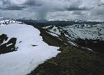
| Looking back along the ridge from the summit with the Tenmile Range in the background. |
Whereas you would hike to the South to reach Grizzly, you will need to turn North to reach Mount Sniktau. To reach the summit of Sniktau follow the ridge down and then up one un-named summit, over this summit, down about a couple of hundred feet and back up several hundred feet. This will put you on top of Mount Sniktau - a total distance of about two miles (or less).

|
| Looking Southeast towards Torreys Peak (left) and Grizzly Peak (right). |
The hike back down follows the route up. The only additional advice I can give would be to follow the ridge rather than trying to travers around the sub-peaks. I say this because as you can see from the images the weather was moving in and I was somewhat in a hurry to leave. Another group of hikers that left the summit as I arrived took a circuitous route around the sub-peaks and I went up and over. I ended up meeting up with them well before the final "summit" where we all had to turn back down the mountain to reach our cars at the parking area below.
Along on this hike with me: No one