The Ohio and Erie Canal Towpath Bike Trail will eventually extend about a hundred miles between Cleveland and New Philadelphia, Ohio. The referenced homepage for the Ohio and Erie Canal has links to maps for the entire towpath trail. About 60 miles are completed but these are not continuous. Because of the gaps in the Canalway, the longest continuous route now is about 30 miles between the southern suburbs of Cleveland and Akron This consists of 19 miles in the Cuyahoga National Park, 6 miles in the Ohio and Erie Canal Reservation which is part of the Cleveland Metro Parks, and about 6 miles in Akron which is part of the Summit County Metro Parks. Most of our riding was done on these trails.
The homepage for the Ohio and Erie Canal Towpath Trail has links to maps for the entire trail. The first three maps are the ones to use for this trip. The following links go to these three maps or you can simply click on the first link and then go to the bottom of the page and click "Next Map to South." These maps are not printable, but right click to download them for printing.
Here is a map of the northern part of the towpath trail which is in Ohio and Erie Canal Reservation (part of Cleveland Metro Parks) and the northern part of the CVNP.
Here is a map of the next part to the south in the southern part of the CVNP.
Here is a map of the next part to the south in Summit County Metro Parks in Akron.
The CVNP website gives general information on the part of the Towpath Trail in the national park. It has a link to a printable map and to maps for all the parking areas.
Here is more information and a printable map for the part of the trail in the Ohio and Erie Canal Reservation of the Cleveland Metro Parks.
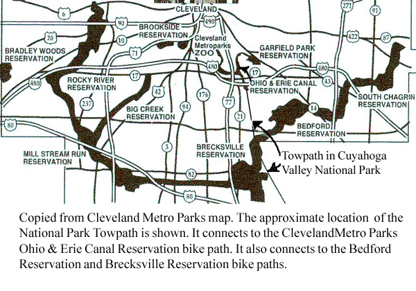
The Cleveland Metro Parks has maps and information about the parks which are called reservations. These parks are connected together by parkways which have bike paths separated from the roads. This website does not have a large map showing the connections between the parks. Here is an enlarged map copied from the Clevaland website showing the Cleveland Metro Parks with the National Park towpath sketched in. A description of a bike ride through the Metro Parks network shows how they are connected together.
Here are some pictures and description of two one day trips along the towpath and connecting trails.
Back to main page.