
The other trips described on this website were taken by Kay and Dale Knapschaefer while in their seventies. This trip from Pittsburgh to Washington was taken by just one of us, Dale Knapschaefer, in July of 2003. We had both taken trips riding parts of the Chesapeake & Ohio Canal Towpath, the Youghiogheny, and the Allegheny HighlandsTrail.
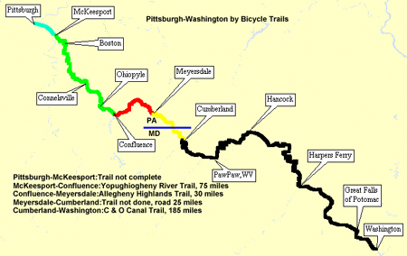
The map above shows the route. In July 2003 a little over 100 miles of trail were completed from McKeesport, PA to Meyersdale, PA. This is the Youghiogheny River Trail and Allegheny Highlands Trail. Then there is a gap of about 25 miles between Meyersdale and and the Chesapeake and Ohio Towpath at Cumberland, MD. From there it is 184 miles on the towpath to Washington, DC.
For information about the trail in Pennsylvania go to the homepage of the Allegheny Trail Alliance, a group of Rails to Trails organizations building the trail. Click on the ATA Information button to learn about the various organizations working on different portions of the trail. Click on the Overview Map button to see a map of the entire.trail. The Overview Maps show the trail divided into segments. The segments 6 through 12 cover the completed trail from McKeepsport, PA to Meyersdale, PA and the segments 13 and 14 give a suggested road route over the uncompleted part from Meyersdale, PA to Cumberland, MD.
Clicking on any segment of the overview map will give a detailed map of that segment. On each detail map there is an Amenity Summary button which gives all the possible information a cyclist needs for that segment of trail; lodging, camping, bike stores, restaurants, even public phones and public internet connections. It is the most complete list for trails I have ever seen.
Here is a description and pictures of the trip from Pittsburgh to Washington.