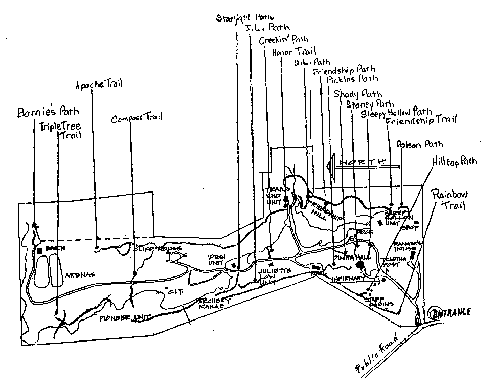
This is a map of our trails. They're kind of hard to see, so here is where they start and end and a little history:
Commonly Used Trails:
Sleepy Hollow Path: Leads hungry Sleepy Hollow campers on a shortcut to the Dining Hall.
Shady Path: Probably the most used path in camp. It leads from the road to the Dining Hall. Very nice to take on a hot day.
Stoney Path: Leads from the lake to the Dining Hall.
Pickle's Path: A path leading from the Dining Hall to the Pool. It was named many years ago after a former Camp counselor. It has been shut down for campers' use the past few years, but has now been renovated so, hopefully will be opened again for future summers.
Perimeter Trails:
Rainbow Trail: The trail that actually starts the perimeter hike. In early summer you can see wild strawberries, sneezeweeds, Indian paintbrush and many other wild plants with a variety of colors; just as in the rainbow. This trail will lead to ALL other trails in the camp.
Hilltop Path: A path that breaks off from Rainbow Trail leading tired hikers ona shortcut to Hilltop instead of the trail ahead.
J.L. Path (Juliette Low): Leads from Juliette Low to Starlight Path.
Starlight Path: This is a very pretty path that leads from the road at Ipesi to two open fields. The first field is an excellent place to do stargazing and the second field used to be used for archery.
Friendship Hill Trails:
Poison Path: This path actually breaks off of Friendship Trail begind Sleepy Hollow and is thick with poison ivy. It doesn't really lead to anything but has been used as an area for "Survival" camping.
Friendship Trail: Starting at Sleepy Hollow it will lead you past Friendship Path and Friendship Hill on to U.L. Path and eventually to Trails End.
Friendship Path: A path that breaks away from Friendship Trail leading hikers to Friendship Hill.
U.L. Path: Actually a shortcut off of Friendship Trail that, when taken, will lead hikers up behind the Unit Leaders' tent at Trails End.
Horse Trails:
Apache Trail: In the summer of 1986 the Advanced Horsemanship Girl Scouts helped to clear a trail from the Horse Barn to Cliff House. A very "special" horse, Apache, also helped the girls. In honor of Apache, the trail is so named
Triple Tree Trail: A trail that is used by the horses to get to Rainbow Trail. It is the trail that has three times as many trees as the other trails (or seems to have.) It starts down by the horsebarn across the road.
Special Trails:
Compass Trail: A trail that starts at Cliff House leading to the road toward the Horse Barn. A nature hike that taught the girls compass skills lead to its name. It is often used as a horse trail as well.
Barnie's Path: A path that leads from the Horse Barn to the "Old" Horse Barn. It is located behind the barn.
Creekin' Path: Across the road from Juliette Low. Follow the creek South and it will take you to the lake by Trails End. Don't forget to look for creek organisms!
Honor Trail: Now sometimes used as a horse trail, it was a trail that was used to take many hikers from Trails End to their "first look" at Cliff House, (the staff's only hide away). It was considered an honor to be a camper and to have seen Cliff House.