- MapInfo Home Page
- GISnet BBS' MapInfo Support Page
- MapInfo FTP Archives
- MapInfo WWW Site
- MapInfo Related Products
- MapInfo ProServer
- ESRI - Home of The GIS People
- Able Software Home Page
- Map Maker - GIS for Windows
- Index of /pub/micro/msdos/win3/demo/
- GISnet BBS' MapInfo Support Page
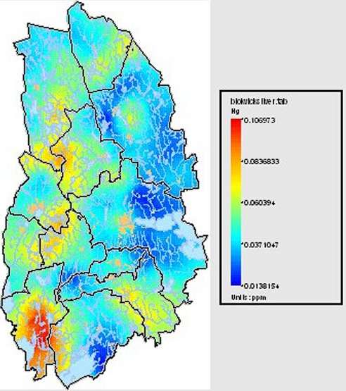
Biogeochemical map over the distribution of mercury
in Örebro county, Sweden. Carte biogéochimique
de la distribution du mercure dans le département d'Örebro,
Suède. Made with Vertical Mapper
- Cartesia AB
- GeoTIFF Web Page
- Autodesk MapGuide Web Site
- GIS Consulting and Mapping
- GeoMedia Web Map
- Baltic GIS IDRISI DATA
- Information of Visual WebMap
- EUROGI Homepage
- GRID-Arendal's Baltic GIS Database
- IDRISI WWW Tutorial - Home
- Nice Geography and GIS Servers
- ORES
- The Soft Earth
- GIS-Web för datadistribution
- GeoTIFF Web Page
- Centre for Environmental Data from Satellites
- SSC - Swedish Space Corporation Kiruna
- EROS Data Center: Earthshots: main menu
- Pathfinder
- Satellite Imagery FAQ 4/5
- SPOT
- Swedish Space Corp Home Page
- USGS: Release of Declassified inventory
- Welcome to Eurimage Scrl
- Welcome to ImageNet
- Picture Gallery NASA
- SSC - Swedish Space Corporation Kiruna
