Click on images to enlarge


Photographs by John Partington
My first visit to Nick and Jan's was via the Port de Salau from the Pallaresa valley in Spain with a laden touring bike. I harboured the ambition to make a circuit from Nick's via the Port d'Aula and Port de Salau in one ride, preferably without luggage! In 2000 the opportunity presented itself.
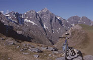
I cycled the steady climb up Port d'Aula. Cresting the ridge (at 2269m) and stepping through to Spain revealed stunning views down the valley of 'La Noguera Pallaresa' river. The autumn foliage in Spain was yellow, in contrast to the darker russets of France. The sun, fairly low in the sky, glinted off the river around 1500m below. To the southwest the 3000m peaks of the Aiguestortes de Sant Maurici, to the southeast the high mountains of Serra de Pilas, Serra Mitjana and the border ridge. Also visible was the dip that framed the Port de Salau, point of return to France.
On the map Port d'Aula to Port de Salau looks like a 4km stroll along the 2000m contour line, I expected it to take me an hour. In reality there are three enormous scoops to traverse. Each 1km flight from one shoulder to the next is lengthened by another km if you stick to solid ground! It took me two hours to reach Port de Salau, part of that spent carrying the VTT. Alone apart from a few chestnut horses, I didn't relish a fall so I walked rather than cycled. Most of the path was beyond my modest all-terrain capability to ride and I was also feeling the effects of the altitude.
The walk overshot the planned time by so much that I started to worry that I'd inexplicably missed the col and was destined to stay up there for ever. I had to reason with myself to stop an early attack on the ridge - which would surely have ended in tears! Reaching Port de Salau was a great moment: there's a depression at the col which means you spend 150m crossing the line of the ridge then suddenly emerge into France and long views down the Salat valley.
When I made my first crossing, with a laden road bike, we were submerged in cloud at this point and starting the descent was very difficult. This time, on an unladen VTT in perfect sunlight, walking was only necessary to lose the first 200m of height down a steep, loose rocky slope. After that a grassy path zigzags down - cling hard onto the brakes and most of it is rideable. Some seriously rocky sections (oh for front suspension .) lead into a wood as you dip below the treeline at about 1400m. The final hurdle is to cross the river Salat at about 1250m - feasible to keep your feet dry even carrying a VTT, though I wouldn't like to try the crossing if the river was in full spate. 2km of dirt road then brings you out onto the tarmac about 6km from Couflens.
At 7pm, two hours after leaving Spain, I was back at Nick and Jan's place with the sun just setting and Nick starting work on the dinner. (Indian food that evening: onion bajees, excellent dall, rice and curried cauliflower, (all home-made as ever), local cheeses, chocolate mousse, wine. Is there a better way to end the day?).
Combining the two cols in one ride, adding in perfect weather, returned me one of the finest days cycling I've had. So far.
John Partington
Navigation: There is often cloud on the summit ridge so a map and compass are useful. The path from Port d'Aula to Port de Salau is hard to pick up at the start - I used a 1:50,000 map and compass bearings for the first kilometre. Nick can loan if you're staying there. The French side descent from Port de Salau is marked with pale yellow paint bars on rocks which are well worth the effort of following! Tackling either col from the Spanish side will give you much harder problems of route finding, but the Port de Salau is the easier to get to with a clear track from the valley till you reach around 1800m. From there upward is still a hard slog!
VTT or road-bike?: Port de Salau is VTT territory and fairly hard work. The 800m of height change between the summit and the dirt road happens over around 6km of path. Port d'Aula can be ridden on a road bike but you'd enjoy the descent a lot more with fat tyres!
The peaks: en route from Port d'Aula to Port de Salau you skirt round: Tuc de Bignal, Tuc de Berbégue, Pic de Montagnol, Pic de Montaud and Pic de Portabèra which gradually creep up in height towards 2500m. Just beyond Port de Salau is Mont Roig which reaches 2858m. 'Tuc' is a Catalan word which seems to be applied to a peak that is more rounded than a 'pic'! (whereas a 'Mont' is a bit more free-standing than either .).
Scenic Value: so long as conditions are clear from 1500m up the views are splendid.