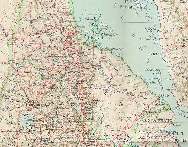
Eritrea in 1938; Map and CommentaryOctober 13, 1998 Dear Netters: Below is a map from 1938 showing how the Italians changed Eritrea's borders during their occupation of Ethiopia from 1936 to 1941. They merged Tigrai into Eritrea, obliterating the previous border. Parrots or Patriots?This action is not really noteworthy except to contradict the claims by the Eritrean government and its faithful parrots at the Dehai website. The Eritrean government first used the phrase that "Eritrea's borders haven't changed for 92 years, " and that the current Ethiopian government is trying to change Eritrea's borders "unlike the three regimes which preceded it." EPLF parrots quickly copied this statement onto the Dehai website without bothering to check its veracity. Well already readers can see at this website Eritrea's redrawn borders in 1987. Now, readers can see the map from 1938 which again disproves their propaganda slogan. So, please Dehai administrators... you don't need to be so slavish in your parroting EPLF propaganda slogans. There is a big difference between a patriot and a parrot. The other points to note about this map are listed below: 1. The Hanish and Zuqar islands are not colored in as belonging to Eritrea. (Eritrean claims to Hanish and Zuqar had arisen from the Treaty of 1922 between Turkey and the Western Powers.) Clearly Eritrea overreached in trying to grab these islands which have now been awarded to YEMEN. The small specks lying south and west of the Hanish and Zuqar islands and very close to the Eritrean coast are the Mohabbakah islets and associated rocks which were awarded to Eritrea. Eritrea might have done better for itself if it had accepted the Yemeni proposal for maritime boundary demarcation in 1996. 2. The map shows the origin of Eritrea's claim against Djibouti territory. Look carefully at the map and notice how Eritrea extends all the way to the Ba-el-mandeb strait. This is the result of the 1935 agreement with Mussolini whereby France was hoping for Italian support against Hitler. In the event the agreement was never ratified, and the Mussolini expansion became null and void. On May 6, 1953, Ethiopia and France (the colonial power in Djibouti) completed a very detailed demarcation of the Eritrean section of the Djibouti-Ethiopia border. Thus, Eritrea now has absolutely no legal claim to this part of Djibouti. Yet, they still dream in Asmara and put out official maps incorporating this territory from Djibouti. (Reference: Eritrea Issues New Map Claiming a Portion of Djibouti). When will they learn? - Dagmawi
|