News and Announcements |
As of May 12, the Eritrean government has unilaterally deployed its army and occupied a border area consisting of Badime (also known as Yirga) and Shiraro districts.Ā The town of Shiraro itself was not occupied.Ā Ethiopia has now responded and moved army units to the area
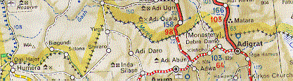
The following map (a commercial Michelin map available in bookstores in the US) shows the area being occupied by the Eritrean army and cleary depicts Yirga (Badime) inside Ethiopia:
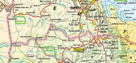
Below is another map (Macmillan World Atlas) showing Badime. Mapping in this remote border area is clearly of low accuracy, yet I have not seen a single map which shows Badime in Eritrea. There is one map which shows Badime right on the border.
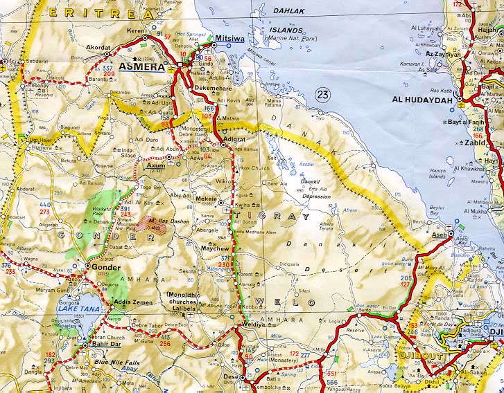
The above map shows the Eritrean border starting from the Tekezze-Sittona junction on the south and roughly following the Sittona (and later the tributary "Etana") before turning north to the Mareb. This is closer to what was specified in the 1902 treaty than the border shown in the Michelin map, but is still too far east. Eritrea of course, demands that the only legal border is that drawn unilaterally by Mussolini in 1934. But the Italians blatantly violated the border treaty when they created the 1934 maps. Readers can verify this for themselves in the article:Ethiopia - Eritrea Border Discussion with close-up maps
(It should be noted that a similar Mussolini-era map has already been rejected by France in the case of Djibouti, where Eritrea is also claiming land)
The general reason for the border dispute is that the border area was never demarcated - it is currently simply drawn as a straight line.Ā However, Badime and Shiraro districts were always administered as a part of Ethiopia - a fact which EPLF has not contested.Ā Instead they claim that a fascist-era Italian map (from 1934) shows that these areas should belong to Eritrea.
Yet, as demonstrated above, an examination of the Italian maps proves that the Italians violated the treaties they signed with Ethiopia and pushed the border to the Tomsa-Tekezze junction on the south. The 1902 treaty states that the border should be located at the Setit-Maieteb junction which is further west towards Sudan. Readers are again encouraged to verify this fact for themselves.
Obviously it is absurd to expect Ethiopia to accept this Italian-created map which illegally violates the treaty and was never "ground-truthed". Ā In addition, all treaties between Italy and Ethiopia were automatically rendered null and void by Mussolini's invasion of Ethiopia in 1935. Still, there was no reason for Eritrea to deploy its army - the issue was in the process of being dealt with peacefully by the bilateral border commission
Of course, Ethiopia has its own maps. The folowing two maps (although unofficial and for planning purposes only)show the new internal zones of Ethiopia (these replace the old "awrajas"). These maps are from the United Nations Development Programme (UNDP) office in Ethiopia. The national map shows the entire country, while the Tigrai map shows the "Tahetay Adiabo" zone which is the area under dispute with Eritrea. Note the careful border delineation which replaces the provisional straight line between the Mareb and Tekeze rivers.
The Ethiopian border is based on over 100 years of administrative records, tax records, voting lists, censuses etc. and establishes Ethiopian sovereignty during all phases of Eritrea's existence. Italy never occupied these areas despite illegally claiming them on its maps.
By contrast the Eritrean border is based on a fascist-era Italian map which was created during the very period that Italy was trying to conquer Ethiopia. In fact Italy instigated several border disputes which Ethiopia was trying to resolve using the League of Nations. As I have mentioned elsewhere, the National Geographic map from 1935 shows the Eritrea - Ethiopia border with the notation "boundary in dispute."
There are many reasons why Eritrea thought it could get away with using force, however, it appears they made a terrible miscalculation.Ā The Eritrean economy is dependent on Ethiopia for 67% of its exports and a large proportion of its imports, particularly food.Ā In addition, the Eritrean government used to derive considerable income from Ethiopian trade passing through Massawa and Assab. Ā An economic recession in Eritrea is now inevitable without even taking into account the costs of a war. Sadly, the Eritrean people are now paying a high price for the arrogance of their leaders.
From Ethiopia's perspective, Eritrean trade amounts to less than 5 percent of its total trade.Ā Also, all the products imported from Eritrea (shoes, sweaters, biscuits) are also produced in Ethiopia. Ā Economically, Eritrea is insignificant for Ethiopia. Ā Ethiopian trade is now conducted through Djibouti port, which was the main port for Ethiopia historically, before Haile Selassie and the Derg governments developed Assab.
In summary, the long-term prospects are bleak for Eritrea, both economically and militarily. Hopefully they will withdraw their army before they cause considerable harm to themselves.
More analysis of the legal issues (these were written early in the conflict and do not iclude the latest information):
Ethiopia: Strong Legal Position - Part 1
Ethiopia: Strong Legal Position - Part 2
Larger version of Michelin map: Northern Ethiopia Region
The XIIIth International Conference of Ethiopian Studies took place in Kyoto, Japan in December 1997.Ā The conference proceedings are now available for purchase.Ā Contact Ms. Yoko Tajimi at JANES (Japanese Association of Nilo-Ethiopian Studies): janes@gaia.h.kyoto-u.ac.jp Ā They are very nice and helpful folks.
The cost is not cheap however.Ā Yen 14,400 plus postage of Yen 2,700 (slower mail) or Yen 4,800 (faster mail).Ā In addition, the Sanwa bank (location of the JANES account), charges a Yen 1,500 fee for converting foreign exchange to Yen.Ā So in total, assuming a Yen:Dollar rate of 130:1, it could cost 142 USD to 160 USD or 18,600 Yen to 20,700 Yen.
Click on the link to see the preliminary list of papers at the Ethiopian Studies Conference Home Page.