
 Climax Caverns
Climax Caverns
![]()
Welcome to part 2 of our section on Climax Caverns. For more photos and information, click on "NEXT" at the bottom of this page.
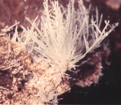
This is a good example of the helictite formations in Glory Hole. It is what cavers call "cave flowers". They are formed by calcite saturated limestone drying out during dry periods, forcing the calcite out. This is definitely not an overnight process but one that takes centuries of slow growth.
See bottom of the page to contact state officials and urge them to support development of these sites as a state park.
![]()
Climax Caverns has been known as an attraction for daring spelunkers for more than 150 years. Only the outer-most rooms nearest the cavern entrance have been visited by most spelunkers however. Many of the novice cavers who have ventured beyond the front area have become lost in the vast maze of the huge cavern. Some have had to be rescued, especially the ill-prepared who went into the cave without sufficient lights.
The tract around the cavern contains about 210 acres; the area immediately around the cave has remained predominantly forested. The section north of the cave site was used for pasturage during the 1960's and had been cleared of much of the old growth trees.
The cave is located at the very edge of Curry Hill which is part of the "Pelham Solution Escarpment" or the rim of the Flint River valley. The valley itself is totally flat land from the river up to the rim of the escarpment. The rim looks like a hill when approaching it but isn't -- it is merely a sharp change of elevation from the valley to the top of the Dougherty Plain.
A county highway runs past the site less than 200 yards from the cave entrance. When the State Highway Department paved this road in the 1950's, they thoughtlessly designed drainage for the road so that it pours directly into the cave itself. Their only concern was to get rid of storm waters rolling down the side of the hill in the ditch beside the highway. Never mind that the "hole" they fed the muddy storm waters into just happened to be one of Georgia's most magnificent treasures. Over the years, the drainage has dug a deeper and deeper trough leading from the roadside to the cave entrance, as the drainage has continued to erode the soil and carry the soil and drainage debris into the cave. Tons of dirt have been washed into the cave since the road paving and as a direct result of the paving itself. Unless the drainage is stopped, it will eventually result in an early death of the cave as passages are filled up.
The land around the cave has been owned by the Long family for many years. Woodrow Long was a member of the Decatur County Commission for a long time and served as Chairman during the 1960's and 1970's. He created a company in the 1970's to manage income from any possible commercial development of the cave.
![]()
T
he cave is located on what is known as the "Pelham solution escarpment", the edge of the valley of Flint River. It is one of the youngest land regions of the southeastern United States -- only a few million years old, folks. The limestone formation the cave is located in was formed from fossilized sea life and sand and muck of the ocean floor. The rocks of the cave contain thousands of tiny fossils. It has been dated to the meeting of the Oligocene and Miocene epochs, or about 7 million to 16 million years old. That makes it some of the "youngest" land mass in the United States and as a result, the limestone is much softer and far more porous than any areas outside the Coastal Plains.The limestone rock is a conglomerate, or combination of sand, muck and both plant and animal life, formed at the bottom of ancient oceans. Over the eons, millions of sea creatures ranging from the miniscule to larger animals died and sank into the muck on the ocean floor. The muck helped preserve their bodies or skeletons, forming fossilized remains. Climax Caverns is full of these fossils--a geologist's delight!
A huge chasm leading from the nearby paved highway has developed since the 1950's, when the road was paved. Road drainage was purposefully fed into the site by the State Highway Department to prevent rain waters from causing erosion alongside the highway. The drainage route started as a small ditch but because of the soft surface soil, has eroded into a giant trough. All this erosion has been fed directly into the cave entrance, bringing tons of soil and trash into the cave, clogging passages into the main portions of the cave.
See below to contact state officials and urge them to support development of these sites as a state park.
![]()
Climax Cave and these other Southwest Georgia natural wonders need your help if they are to survive. If you are proud of your state's natural wonders, help support its development and preservation as a state park -- contact your state senator, state representative and Governor Barnes and urge them to create a major state park for Climax and the natural wonders in adjoining Grady County.
You can send a message to Georgia Governor Barnes and let him know of your support. Take time to send him and the Georgia Parks Division and Tourist Division a note.
These are links to their contact pages:
 Georgia Governor
 State Parks Division
 Division of Tourism
![]()