 The Alaska State Ferry left Sitka at 3:45 am. We were expected to get into Petersburg at 3:45 pm. We took a tent and sleeping bag upstairs and went up to the solarum level, but no one else had tents up. We took it back to the truck and slept in one of lounges.
  Early in th morning we passed by a island that had two crosses on the rocky beach. It reminds one of what this country can be like with the bad storms and freezing temperatures. It is a great place to visit but one must live here during the winter to really feel what Alaska is like.
This ferry was pretty crowded with a lot of passengers who were taking the trip straight from Juneau to Bellingham, WA. The sky was blue and not too cold out.  There were lots of senior citizens on board and very few kids. Dale reported that some of them were walking laps around one of the decks of the ferry. They announced several times whale sightings and one black bear on the shore of an island. We talked to one couple from Longview. They had taken their motor home up the Dempster Highway north from Dawson City. They turned back at the Artic Circle. They said it was quite muddy and there was a surprisingly fancy restaurant that served prime rib near the Artic Circle.
We got into Petersburg at 4:15 pm and drove around the town. The view from the ferry as we got into Petersburg was of a quaint fishing village that was quite spread out with several piers, fish processing plants and homes along the waterfront. The ferry terminal is just a mile south of town. 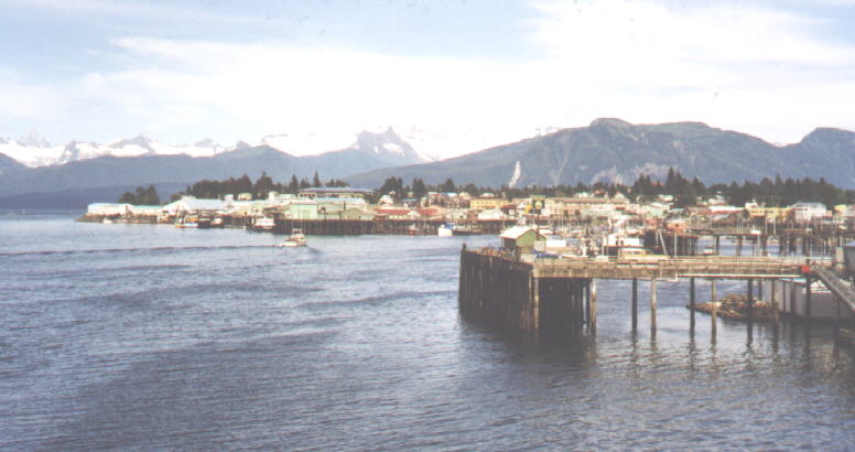
 Not much was open on a Sunday afternoon. We drove north a mile and a half out of town past Sandy Beach and the airport to the Tent City Campground. This is a unique campground owned by the city. For $5 a night you can pitch your tent on a wooden platform that looked like the shell to a small house. Some had plastic covering them. There were about 50 of these platforms connected by a wooden boardwalk. The ground underneath was muskeg. There was an outside area used for cooking, toilets, showers and a payphone. This campground is usually full for the summer with cannery workers, but this year the fishing had been poor. The campground was less than half full. We stopped at Sandy Beach, which was a large beach with picnic shelters and a play area. The beach was more rocks and shells than sand. The newspaper reported that they had to kill a bear here because it would not leave people alone. They tried to trap it with bait, but it wouldn't take the bait.
We drove out Frederick Boardwalk, which is actually the name of a street that used to be a boardwalk. It is now a gravel road connected homes people have buildt themselves on waterfront property.  These people had acquired the land through a lottery some years ago with the understanding they would have no city services (ie roads, water, electricity). Well it looked like that was all changing. The road was quite rough and seemed to go on forever so we turned around. Back in town we stopped at Eagle Roost Park, a small city park with a garden and wooden stairs down to a rocky beach.
We took Nordic Drive south which turns into the Mitkof Highway. This highway goes south for 34 miles along the Wrangell Narrows. We had a hard time finding the Falls Creek Fish Hatchery at mile 11. If you turn left here you are on the north end of the 21 mile Three Lakes Loop Road which comes out farther south on the Mitkof Highway. At mile 14 we walked out on a newly buildt boardwalk to the Blind River Rapids. There were lots of salmon in the river and we saw at least three eagles.  Next we stopped at the Trumpeter Swan Observatory. A short boardwalk led to a small building with little window slits designed to peer out on the water and not disturb the waterfowl. We stopped at mile 17 for the Crystal Lake Fish Hatchery. The lake was not accessible. The Mitkof Highway turned gravel at this point. The Man-Made Hole Lake (that really is the name of it) was at mile 20. From the road there appeared to be a picnic table on an island in the middle of a lake. Getting closer we realized the land the picnic table was on could be reached by a short walk. The lake was formed when they diverted a creek to buildt the highway.
  At mile 21 we took a right on Forest Service Road 6245. About a quarter mile down the road was the Ohmer Creek Campground with 15 campsites. Only the host and one other campsite were being used. We saw a porcupine running along side the road, at first we thought it was a bear cub. Continuing on we stopped at Woodpecker Cove where an older couple had set up their RV. They told us about another campsite and two lakes (not on the map) in the area. Later we discovered that the FS roads to the lakes were closed. We passed the campsite they told us about and continued up a steep, rough road near December Point. We were hoping to get a good view of the water, but decided the road was too rough.
We drove back to the campsite overlooking the Sumner Straits and Zarembo Island. Previous campers had left boards around a fire pit for seating and a crude swing near the cliff overlooking the water. The campsite had several tall tree stumps and was down in a gully. I even found a husky football which Jacob appropiately wanted to throw away into the ocean since both his parents are from WSU. I told him that we would take it back with us. Even if it was from UW, it would be something to remember the trip by. We ate crackers and roasted marshmellows for dinner and split a bottle of wine. The sky was clear and it wasn't too cold even near the water. Note: Found out Randy Johnson, pitcher for the Seattle Mariners had been traded today. 100 miles today 3550 miles total