We made it to the ferry terminal in Wrangell at 3:30 am for the 5:00 am sailing to Ketchikan. We left about a half hour earlier than scheduled. We got to Ketchikan at 11:00 am. It was overcast when we got there but the sun came out shortly after we got in. I was a little worried about the weather since Ketchikan is suppose to be the rainiest town in North America, getting an average of 160 inches a year. We had 7 hours in Ketchikan today minus 2 hours we would have to waste waiting for the fery to Prince of Wales Island. We knew we'd be back here in two days for another 12 hours. Our plan was to do the 18 mile stretch of road north of town today and when we got back Friday we would do the southern part of the road. On both days we would spend some time in town.
The ferry terminal in Ketchikan is two miles north of town. We headed 18 miles north to Settler's Cove Picnic Area and Campground. There are 10 camping sites here and also a quarter mile hike to view some falls. There were several picnic tables along the way overlooking the ocean. One man was standing in Lunch Creek fishing with his dog where the creek ran into the ocean. On our way back south we took several side streets. Knudsen Cove lead to a marina. Point Higgins went through a residential community and ended up at school.
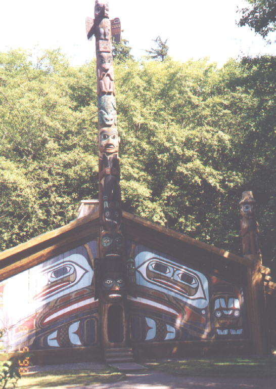
 We stopped at Totem Bight State Historical Park. In the center was a grassy area with a traditional clan house. The clan house had a front entrance with a pole in the middle of the house and inside was a fire pit and more totems that were used as beams. This house was large enough for several families to live in during the winter. There was a giftshop near the parking area and a path that lead through the woods with about a dozen totem poles. There is no charge.
Further south we took the Mud Bay turnoff where there were houseboats in a marina. Just before Revilla Road we passed the pulp mill which has been recently shut down. At Revilla Road we turned inland. This takes you to several lakes and campgrounds. ![]()
 Signal Creek Campground (25 sites), Three C's Campground (4 sites) and Last Chance Campground (23 sites) are all on Ward Lake. At Connell Lake, a water resevoir the pavement ended. We turned off on the Brown Mountain Road where there was a lot of logging. Turned around and continued on to Harriet Hunt Lake. At this lake a couple were sitting near a large turnck with dozens of canoes and life jackets, all by themselves. We discovered later that they were waiting for a bus load of tourists to show up. There was an old A-frame house and a cable going up the side of a mountain. Somewhere around here Dale got beaned in the head by a flying rock from a passing vehicle, his window was open. If his window had been shut, it might have shattered. We never did find the rock. We drove back to the main highway and into Ketchikan around 3:00 pm. We drove around looking for an ATM and finally stopped in the Plaza Mall. We asked for directions to the Subway. The directions were a bit hard to follow so we parked in the general area and asked someone else for directions. Found it! I'm sure it was only partly cloudy when we went into Subway, but when left it was pouring down rain. What a shock! We thought we'd eat our sandwiches while waiting for the ferry and walked around town. Dale found a bookstore and Jacob and I discovered Creek Street. We drove around some of the residential area. The land near the waterfront is quite flat, but if you go more than a half mile inland the hills reminded us of San Francisco.
We went to the ferry at 4:00 pm and they told us we could come back at 5:15 pm, so we drove around a bit more before boarding for 6:00 pm departure to Prince of Wales Island.  This was a smaller ferry, with a lot of local families on board. Prince of Wales Island is the largest in southeast Alaska and the third largest in the United States (only Kodiak Island and the big island of Hawaii are larger). It has only been accessible by state ferry since 1974. This island has over a thousand miles of roads, more roads than any other island in southeast Alaska, but only 34 of them are paved. The rest of them are chip-sealed or shot rock. Most of the roads were buildt for logging. Besides logging this island has a history of mining, fishing and canning. The Tlingits have lived here for several hundreds of years and the Haida Indians from the Queen Charlotte Islands arrived here in the 1700's, inhabiting the southern part of this island. It is not know why part of the Haida tribe left Queen Charlotte. But to this day they are still friendly with one another as they speak the same language, have potlachs together and sometimes inter-marry. It is strange that they find themselves governed tow countries where they were one tribe at one time.
We arrived in Hollis at 9:00 pm. It was overcast, but warm and getting dark. I thought Hollis would be just a ferry terminal, but there was a small community a little ways past the terminal, consisting of a few homes, mostly trailers and lot of semi-containers and a public library. We drove through Klawack and into Craig on paved road. The posted speed limit was 50 mph, but everone was going 30 mph. It was like they were programed to drive 30 mph on the gravel roads and couldn't go any faster. Most of the cars on the road were from the ferry. Craig had a Burger King, but it was closing. We went back to Klawock and stopped at a convenience store/gas station for food and gas. We asked where we could pull over for the night and someone suggested a sideroad not too far away. We fell asleep around 11:00 pm.
150 mile today 3900 miles total