This material can be used to
fulfill partial requirements for the Green Star
and the Watercraft Badge
Ever wonder why on a calm
summer morning with the weather looking like a perfect day-trip by canoe, the weather goes
bad as the day progresses? By noon a light breeze starts up and pretty soon the
wind is strong, the water is choppy,
and you have to fight the waves. By evening all is calm again. Well
the reason for this is the way weather works. The sun heats up the land
during the morning, faster than the water. The air on the shore starts to
rise and draws the colder air towards it to fill the void. A breeze is
created that causes the waves to be choppy. At night there is no more heat
from the sun, so the lake is calm again. The following is a brief
understanding of the many major forces that affect our weather.
Weather is caused by the
mixing of heat and air movement, water moisture, air pressure, and
geo-physical features. This weather occurs in our atmosphere which surrounds
the earth and provides us with the air we breathe.
HEAT
AND AIR MOVEMENT
 The sun is a major contributor to our
weather. Heat makes water evaporate into the air. The water vapor then cools, forms
into tiny droplets of water which form clouds. The uneven heating and cooling
of the Earth's surface causes air movement.
Heat from the sun is absorbed by the
Earth and causes the water cycle. When a large amount of air is cooled over
the poles of the Earth, a cold air mass is formed. Warm air masses develop
over warm land and water near the equator. When warm air and cold air meet,
the warm air rises over the cold air mass causing a convection current (wind).
If the Earth did not turn, the air masses would always flow directly north or
south. Instead, these air masses move at an angle. The uneven geophysical
features of the Earth cause large air masses to break up into smaller ones.
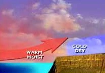
When cold air comes together with warm air, the place where they meet is
called a weather front.
The sun is a major contributor to our
weather. Heat makes water evaporate into the air. The water vapor then cools, forms
into tiny droplets of water which form clouds. The uneven heating and cooling
of the Earth's surface causes air movement.
Heat from the sun is absorbed by the
Earth and causes the water cycle. When a large amount of air is cooled over
the poles of the Earth, a cold air mass is formed. Warm air masses develop
over warm land and water near the equator. When warm air and cold air meet,
the warm air rises over the cold air mass causing a convection current (wind).
If the Earth did not turn, the air masses would always flow directly north or
south. Instead, these air masses move at an angle. The uneven geophysical
features of the Earth cause large air masses to break up into smaller ones.
When cold air comes together with warm air, the place where they meet is
called a weather front.
WATER
MOISTURE
 Water moisture is a major factor of weather.
The constant movement of water in and out of our atmosphere is called the
water cycle.
Water moisture is a major factor of weather.
The constant movement of water in and out of our atmosphere is called the
water cycle.
The rain that falls from the
sky today has been around for thousands of years.
The molecules of water in today's rainfall might have
been in yesterday's cloud or last week's dew, or in a lake or ocean.
Although water takes three basic forms (liquid, solid and gas) we see
water in many forms such as frost, snow, rain, and clouds.
As a liquid, we see water in the lakes and oceans, we see it falling as
rain, and we see it come into our home for drinking or washing.
As a solid, we see water as ice and snow.
As a gas, water vapor is always floating in the air.
Water changes from liquid to solid by freezing.
It changes from liquid to gas by evaporation.
It changes from gas to liquid by condensation. You can't see it, but the air contains a lot of water.
Warm air can hold more water vapor than cold air.
When air gets cold, the water vapor condenses into clouds in the form
of rain or precipitation.
And when warm air holds a lot of water vapor, the air can feel sticky
and damp. The amount of water in
the air is called humidity. The cycle of evaporation, condensation, and precipitation never ends.
AIR
PRESSURE
 Air pressure is the weight of air in our atmosphere pressing down upon the
Earth. Cold air masses are high in density because the molecules are close
together. They are called high pressure areas. Cold air masses, therefore,
have greater air pressure than warm air masses.
Air pressure is the weight of air in our atmosphere pressing down upon the
Earth. Cold air masses are high in density because the molecules are close
together. They are called high pressure areas. Cold air masses, therefore,
have greater air pressure than warm air masses.
The wind blows because air
has weight. Cold air weighs more
than warm air, so the pressure of cold air is greater. When the sun warms the air, the air expands, gets lighter,
and rises. Cooler, heavier air
blows to where the warmer and lighter air was, or in other words, wind usually
blows from areas of high air pressure to areas of low pressure. If the high
pressure area is very close to the low pressure area, or if the pressure
difference (or temperature difference) is very great, the wind can blow very
fast as in a hurricane.
GEOPHYSICAL
FEATURES
Weather is affected by the surface conditions of land and water (oceans,
lakes, polar ice). Very little moisture is available to be picked up over deserts.
Moisture however is more easily picked up over large bodies of water, especially
where the hot sun can cause the water to evaporate. When wind pushes
clouds over the mountains on land, the clouds are forced to rise. When the
clouds rise, they are no longer able to carry as much water and the result is
rain. This is why on the west coast of North America rain occurs west of
the Rocky Mountains. On the other side of the mountains weather conditions
are very dry. Another factor affecting the weather is the fact that
land heats up and cools down faster than water.
WEATHER
INDICATORS
Clouds:
 Clouds
form when water vapor rises, cools, and condenses. Here are the basic cloud types:
Cumulus are puffy mid-level white clouds
made of water and ice, usually associated with fair weather.
These clouds look like puffy pieces of cotton with flat
bases (cumulus means heap or pile). They are usually "foul-weather clouds".
Nimbostratus
clouds are thick dark low-level clouds that can produce rain or drizzle.
Cumulonimbus clouds (thunderheads) are deep dark and puffy clouds that often
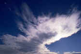
produce thunderstorms. Cirrus are high wispy clouds made of ice, also occurring with fair
weather (cirrus means curl). Cirrus clouds usually appear a few
days before a storm. Stratus are flat low
clouds made of water which sometimes produce light rain or drizzle (fog is a
stratus cloud). These clouds are spread out sheets of flat, gray clouds that block out the sun
(stratus
means spread out).
Clouds
form when water vapor rises, cools, and condenses. Here are the basic cloud types:
Cumulus are puffy mid-level white clouds
made of water and ice, usually associated with fair weather.
These clouds look like puffy pieces of cotton with flat
bases (cumulus means heap or pile). They are usually "foul-weather clouds".
Nimbostratus
clouds are thick dark low-level clouds that can produce rain or drizzle.
Cumulonimbus clouds (thunderheads) are deep dark and puffy clouds that often
produce thunderstorms. Cirrus are high wispy clouds made of ice, also occurring with fair
weather (cirrus means curl). Cirrus clouds usually appear a few
days before a storm. Stratus are flat low
clouds made of water which sometimes produce light rain or drizzle (fog is a
stratus cloud). These clouds are spread out sheets of flat, gray clouds that block out the sun
(stratus
means spread out).
 |
 |
 |
 |
 |
 |
 |
 |
| Cumulus |
Cumulonimbus |
Cirrus |
Stratus |
Cloud Coverage:
Overcast - The sky is completely (or greater than 90%) covered by
clouds.
Broken - Mostly cloudy skies (50%-90% of the sky covered by clouds).
Scattered - Partly cloudy skies (10%-50% of the sky covered by clouds).
Clear - The sky is cloud free (or less than 10% cloud coverage).
Wind:
Wind has a speed and a direction. Wind speed is measured by an anemometer.
Wind direction can be estimated by noting which way a flag is blowing. Remember wind direction is taken as the direction the wind is coming from.
Wind speed also affects temperature. Say for example the outside
temperature is -12ºC (10ºF). In a 40 km/h (25 mph) wind
this would be equal to a wind chill factor of -34ºC (-29ºF).
|
Estimated Windspeed (km/h) |
| |
Outside Temperature (ºC) |
| Calm |
10 |
4 |
-1 |
-7 |
-12 |
-18 |
-23 |
-29 |
-34 |
-40 |
Wind Chill Factor Danger Level |
| 8 |
9 |
3 |
-3 |
-9 |
-14 |
-21 |
-26 |
-32 |
-38 |
-44 |
Little
danger to a properly clothed person |
| 16 |
4 |
-2 |
-9 |
-16 |
-23 |
-29 |
-36 |
-43 |
-50 |
-57 |
| 24 |
2 |
-6 |
-13 |
-21 |
-28 |
-36 |
-43 |
-50 |
-58 |
-65 |
Increasing
danger. Check for frostbite |
| 32 |
0 |
-8 |
-16 |
-23 |
-31 |
-39 |
-47 |
-55 |
-63 |
-71 |
| 40 |
-1 |
-9 |
-18 |
-26 |
-34 |
-42 |
-51 |
-59 |
-67 |
-76 |
Great
danger as the wind speed increases.
Stay inside your home or tent |
| 48 |
-2 |
-11 |
-19 |
-28 |
-36 |
-44 |
-53 |
-62 |
-70 |
-78 |
| 56 |
-3 |
-12 |
-20 |
-29 |
-37 |
-46 |
-55 |
-63 |
-72 |
-81 |
| 64 |
-3 |
-12 |
-21 |
-29 |
-38 |
-47 |
-57 |
-65 |
-73 |
-82 |
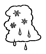
Precipitation:
 In cold air way up in the sky, rain clouds will often form. Rising warm air carries water
vapor high into the sky where it cools, forming water droplets around tiny
bits of dust in the air. Some
vapor freezes into tiny ice crystals which attract cooled water drops.
The drops freeze to the ice crystals, forming larger crystals we call
snowflakes. When the snowflakes become heavy, they fall.
When the snowflakes meet warmer air on the way down, they melt into
raindrops. Often cloud droplets combine together around dust or sea salt particles.
They bang together, rise and fall in the cloud, grow in size with
layers of ice until they're heavy enough to fall as hail.
In cold air way up in the sky, rain clouds will often form. Rising warm air carries water
vapor high into the sky where it cools, forming water droplets around tiny
bits of dust in the air. Some
vapor freezes into tiny ice crystals which attract cooled water drops.
The drops freeze to the ice crystals, forming larger crystals we call
snowflakes. When the snowflakes become heavy, they fall.
When the snowflakes meet warmer air on the way down, they melt into
raindrops. Often cloud droplets combine together around dust or sea salt particles.
They bang together, rise and fall in the cloud, grow in size with
layers of ice until they're heavy enough to fall as hail.
Thunder and Lightning:

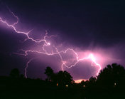 When cold air meets warm air, the cold air sinks
and digs under the warm air, forcing it to rise quickly.
The rising air takes water vapor with it, which cools and condenses,
forming cumulonimbus clouds, sometimes called thunderheads.
These are deep, dark, tall clouds, formed as water vapor condenses,
releasing heat, pushing the air higher and higher.
No one is sure exactly why lightning occurs, but water droplets and ice
particles bang together in the cloud, helping to build up positive and negative
electrical charges. The positive
charges gather near the top of the cloud and the negative charges gather in the
middle. More positive charges
gather near the bottom of the cloud and on the ground below the cloud.
Electricity flows between the charges.
The flash of electricity is lightning.
Lightning heats the air around it. The
heat causes the air to expand with an explosive force resulting in a loud sonic
boom we call thunder.
When cold air meets warm air, the cold air sinks
and digs under the warm air, forcing it to rise quickly.
The rising air takes water vapor with it, which cools and condenses,
forming cumulonimbus clouds, sometimes called thunderheads.
These are deep, dark, tall clouds, formed as water vapor condenses,
releasing heat, pushing the air higher and higher.
No one is sure exactly why lightning occurs, but water droplets and ice
particles bang together in the cloud, helping to build up positive and negative
electrical charges. The positive
charges gather near the top of the cloud and the negative charges gather in the
middle. More positive charges
gather near the bottom of the cloud and on the ground below the cloud.
Electricity flows between the charges.
The flash of electricity is lightning.
Lightning heats the air around it. The
heat causes the air to expand with an explosive force resulting in a loud sonic
boom we call thunder.
In case you are still
frightened about all the damage and danger of thunderstorms here is some safety
advice:
-
Check
for any dead or rotting trees near your house that might be struck and fall
down.
- Get up-to-date
information by listening to the radio and/or watching TV.
-
Stay away from
faucets, sinks, and bathtubs, because electric current can travel through the
metal water pipes.
-
Turn off
or unplug all electrical appliances.
-
Stay off
the telephone.
- If you are
outside, the safest place you can be is laying flat on the ground in the open.
Remember lightning strikes the tallest objects.
Snow:
 Snowflakes form when water vapor freezes into
ice crystals in cold clouds. The ice crystals attract cooled water droplets to form
various shapes. They get heavy and
fall. If the air is cold enough,
the snow falls all the way to the earth without melting.
If the ground is freezing, the snowflakes stick to the ground. The shape of snowflakes depends
on the temperature of the air. In
colder air, the snowflakes may look like needles or rods.
When the air is a little warmer, the shapes can become very complicated.
Snowflakes form when water vapor freezes into
ice crystals in cold clouds. The ice crystals attract cooled water droplets to form
various shapes. They get heavy and
fall. If the air is cold enough,
the snow falls all the way to the earth without melting.
If the ground is freezing, the snowflakes stick to the ground. The shape of snowflakes depends
on the temperature of the air. In
colder air, the snowflakes may look like needles or rods.
When the air is a little warmer, the shapes can become very complicated.
A blizzard is a heavy snowstorm
with very cold temperatures, sustained winds of at least 55 km/h (35 mph), and visibility
of less than 0.4 km (0.25 miles). When a mass of polar air and warm air meet, the polar
air pushes the warm air up and settles in the atmosphere where the water vapor
forms snow clouds. Then winds and low temperatures combine with the snow to
create a blizzard.
Tornadoes:

 A tornado is a spinning funnel of air. A tornado
forms when a funnel of warm air quickly rises from the earth, most of the time
into a thundercloud. In North America, when cold dry air from the Rockies moves
east onto a warm wet air mass flowing north, if strong winds set the upward
moving cold air mass of air spinning, it can turn into a tornado. Tornadoes that
are over water are called waterspouts, and tornadoes that are over the desert
are called dust devils.
A tornado is a spinning funnel of air. A tornado
forms when a funnel of warm air quickly rises from the earth, most of the time
into a thundercloud. In North America, when cold dry air from the Rockies moves
east onto a warm wet air mass flowing north, if strong winds set the upward
moving cold air mass of air spinning, it can turn into a tornado. Tornadoes that
are over water are called waterspouts, and tornadoes that are over the desert
are called dust devils.
Hurricanes:
Hurricanes are violent storms that develop from
cyclones that form over a tropical ocean. The cyclone will pass through two
stages before it becomes a hurricane. The first stage is a tropical depression.
The next stage is a tropical storm and then it becomes a hurricane. In order for
the storm to be called a hurricane the winds must exceed more than 120 km/h (75
mph).
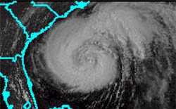 Hurricanes are usually formed
in late summer or early autumn over a tropical ocean where the water is above 25ºC (80ºF). Warm, moist air will
rise rapidly letting the cooler air move in. Then the air will begin to spin and
the air pressure in the center will drop. More air will get sucked in and the
air will spin faster. Then the rapidly spinning air will rise into the shape of
a doughnut and carry strong winds, rain, and clouds. Now a hurricane is formed
Hurricanes are usually formed
in late summer or early autumn over a tropical ocean where the water is above 25ºC (80ºF). Warm, moist air will
rise rapidly letting the cooler air move in. Then the air will begin to spin and
the air pressure in the center will drop. More air will get sucked in and the
air will spin faster. Then the rapidly spinning air will rise into the shape of
a doughnut and carry strong winds, rain, and clouds. Now a hurricane is formed
The diameter of a hurricane can
vary from 40 to 1000 km (25 to 600 miles) wide and it can travel at speeds 15 to
50 km/h (10 to 30 mph). Wind
speeds can blow from 120 to over 320 km/h (75 to over 200 mph). In the center of the hurricane, known
as the eye, the winds are very calm. The eye can measure from 30 km (20 miles) in
diameter. Hurricanes can cause tremendous coastal damage. They need warm water
to form and keep going so hurricanes break up over land.
PREDICTING
WEATHER
These are a number of common indicators to use
when you are out camping and do not have a weather report handy:
- When forecasting daytime temperatures, if
cloudy skies are expected, forecast lower temperatures than you would predict if
clear skies were expected. At night cloud cover has the opposite effect. If skies are
clear, heat emitted from the earth's surface freely escapes into space,
resulting in colder temperatures.
- Cloudy, unsettled weather can occur when; the wind blows strong early in
the morning, or when clouds move rapidly in different directions.
- Steady rain or snow can occur when wiinds blow from the southeast to northeast.
- Bright weather is ahead when; wind chhanges from south to southwest or from
east to northwest or when the moon shines brightly and there is a light wind.
- Clearing skies can occur when the temmperature falls rapidly in the afternoon
and clouds become lumpy.
- The higher
the clouds, the better the weather.
-
Sun or moon
halos indicate a coming rain (or snow): the larger the halo, the nearer the
precipitation. This is more likely to be true
during warm weather than during midwinter.
-
Crickets
are accurate thermometers; they chirp faster when warm and slower when
cold.
-
When leaves
show their backs, it will rain.
-
When smoke
descends, good weather ends.
- When dew is on the grass, rain will never come to pass.
- Red sky at night, Sailor’s
delight. Red sky at morning, Sailors take warning! When the sky is red colored in the west at sunset, it means that
there is a breakup of the clouds and clearing skies.
- Fair weather is likely ahead when youu see
wispy, thin cirrus clouds that look likes mares' tails and are blown about by
winds high overhead.
- Cumulus clouds,
with their flat base and puffy appearance, are clearly defined and easy to
identify. If they don't have too much vertical growth, fair weather is ahead,
but the greater the vertical development, the greater the chance of the weather
becoming showery with possible thunderstorms.
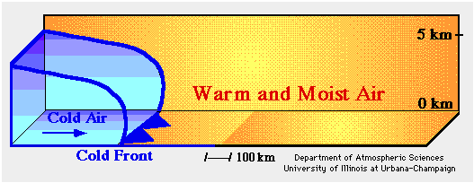
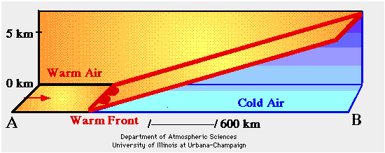
Fronts:
Air masses have different characteristics,
depending on where and when they formed. When air masses move into areas
different from where they began, these characteristics can change. Fronts are the boundaries
between these air masses. When air masses and fronts collide, the weather battle
begins. When warm air pushes cold air it is called a warm front. The
opposite is true for a cold front. Cold fronts often bring thunderstorms
and can result in substantial temperature changes over a short period of
time. Warm fronts tend to take longer to occur, and the storm could take
hours to pass.
Weather Forecasting:

 A daily weather forecast involves the work of thousands of observers and
meteorologists all over the world, and the work of thousands of
machines. Modern computers make forecasts more accurate than ever, and
weather satellites orbiting the Earth take photographs of clouds from space.
Forecasters use the observations from ground and space, along with
formulas and rules based on experience of what has happened in the past, and
then make their forecast.
A daily weather forecast involves the work of thousands of observers and
meteorologists all over the world, and the work of thousands of
machines. Modern computers make forecasts more accurate than ever, and
weather satellites orbiting the Earth take photographs of clouds from space.
Forecasters use the observations from ground and space, along with
formulas and rules based on experience of what has happened in the past, and
then make their forecast.
Tools used to Observe
Weather:
A thermometer measures temperature.
A barometer measures air pressure.
A rain gauge measures precipitation.
An anemometer measures wind speed.
A radiosonde attached to a weather balloon measures weather high in the
atmosphere.
A satellite takes pictures of clouds from space.
Radar shows where and how much rain is falling.
Eyes and ears observe clouds, precipitation, lightning, thunder.