Copyright 1997 - 2006 by the Lotz Family
To the Smokies from Townsend
Laurel Creek Road - The Right
Fork
Cades Cove Picnic Area, Cades Cove,
Horseback Riding, and
Cades Cove Campground
To the Smokies from Townsend
Laurel Creek Road - The Right
Fork
Cades Cove Picnic Area, Cades Cove,
Horseback Riding, and
Cades Cove Campground
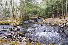
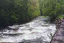
Turn right onto Laurel Creek Road to go to Cades
Cove and the Cades Cove Campground. The road parallels the Laurel
Creek and is the typical twisting and turning mountain road. The views
of the forests and the river are inspiring. Keep your eyes open for some
of the spectacular rock outcrops that are 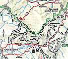 along
the side of the road. In the spring, the wild flowers and flowering Redbud
trees are so spectacular they can be distracting to the driver - keep your
eyes on the road! On the return trip let someone else drive so the first
driver can take in the views. In the summer and fall, especially on weekends
or holidays, traffic can be bumper-to-bumper on this road. Cades Cove is
one of the most visited areas of the Park. A word of advice: make sure
that your vehicle is in good working order so it won't overheat in the
slow moving traffic in the summer. Distance from Townsend is nine miles
and takes about 20 minutes, during periods of light traffic.
along
the side of the road. In the spring, the wild flowers and flowering Redbud
trees are so spectacular they can be distracting to the driver - keep your
eyes on the road! On the return trip let someone else drive so the first
driver can take in the views. In the summer and fall, especially on weekends
or holidays, traffic can be bumper-to-bumper on this road. Cades Cove is
one of the most visited areas of the Park. A word of advice: make sure
that your vehicle is in good working order so it won't overheat in the
slow moving traffic in the summer. Distance from Townsend is nine miles
and takes about 20 minutes, during periods of light traffic.
 For
additional information on the park, purchase a copy of the "Smokies Guide"
at any visitor center. It costs 25 cents and is published four times a
year by the Great Smoky Mountains Natural History Association.
For
additional information on the park, purchase a copy of the "Smokies Guide"
at any visitor center. It costs 25 cents and is published four times a
year by the Great Smoky Mountains Natural History Association.
There is also a fabulous picnic area off to the left just before entering Cades Cove. Turn left at the sign and turn left again to enter the picnic area. We like to pick up food in Townsend and drive to this picnic area to eat. There is a stream that runs through the picnic woodlands and several hiking trails can be reached from this area. Note: Rest rooms are located here!
Horseback riding is also available here. Turn just as if you were going to the picnic area off of Laurel Creek Road, but continue down the road instead of turning into the picnic area. Carriage rides are also offered. Be aware that horseback riding is seasonal, so call ahead if you are visiting in the off season. Riding rates were around $15-$20 per hour at the time we were there.
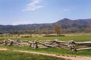
Just down the road from the picnic area is the entrance
to Cades Cove. This is a eleven mile paved, one way 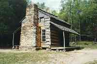 loop
road that travels a relatively "flat" (in mountain terms) area between
the mountains. This was one of the first areas settled by the white man
in the Smokies. Several historic log homes and churches dating earlier
than the late 19th and early 20th century are scattered
throughout the cove and are open to visitors. At the mid-point of the loop
are the Cades Cove Visitor Center, Cable Mill, and farm house with several
out-buildings. Visitors can watch the water powered grist mill grind corn
into meal and wheat into flour. The finished products are available for
purchase. Demonstrations of farming and homemaking activities are
loop
road that travels a relatively "flat" (in mountain terms) area between
the mountains. This was one of the first areas settled by the white man
in the Smokies. Several historic log homes and churches dating earlier
than the late 19th and early 20th century are scattered
throughout the cove and are open to visitors. At the mid-point of the loop
are the Cades Cove Visitor Center, Cable Mill, and farm house with several
out-buildings. Visitors can watch the water powered grist mill grind corn
into meal and wheat into flour. The finished products are available for
purchase. Demonstrations of farming and homemaking activities are 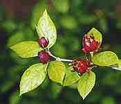 conducted
on a seasonal basis by the National Park Service. Information, exhibits,
and publications related to the Park, its resources, and history can be
found at the visitors center. Important note: Rest rooms can be found here,
too!
conducted
on a seasonal basis by the National Park Service. Information, exhibits,
and publications related to the Park, its resources, and history can be
found at the visitors center. Important note: Rest rooms can be found here,
too!
 A
favorite area of ours at the visitors center is located behind the first
barn. You have to cross over the water flume for the Cable Mill to view
the barn up close. Continue on behind the barn where several streams cross
the area. This spot offers nice viewing of the streams as well as some
limited scenic exploring opportunities. The kids seem to enjoy this particular
area. As with all wilderness treks, parents should accompany their kids
on all adventures.
A
favorite area of ours at the visitors center is located behind the first
barn. You have to cross over the water flume for the Cable Mill to view
the barn up close. Continue on behind the barn where several streams cross
the area. This spot offers nice viewing of the streams as well as some
limited scenic exploring opportunities. The kids seem to enjoy this particular
area. As with all wilderness treks, parents should accompany their kids
on all adventures.
At certain times, the Cove road is closed to vehicles for the benefit of bicycle and foot traffic - usually on Saturday mornings and one other weekday morning. Hay rides along the Cove road are offered by the Park Service. Check the Park publications for details and the exact times for these activities.
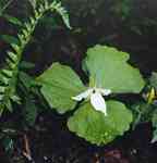
 Be
sure to watch for wildflowers on your adventures in the park. There
is such diversity because of the large change in elevations, that something
is always blooming from late March through July. The trilliums, flame azaleas,
rhododendron, and red bud trees are spectacular when they are blooming.
Be
sure to watch for wildflowers on your adventures in the park. There
is such diversity because of the large change in elevations, that something
is always blooming from late March through July. The trilliums, flame azaleas,
rhododendron, and red bud trees are spectacular when they are blooming.
Also accessible from the Caves Cove loop road is
Rich
Mountain Road. This road used to be the main road into the cove from
the rest of the world in the early 1800s. The road begins off of the Cades
Cove loop road about a mile before reaching the Visitor Center. It's on
the right. We have traveled this gravel road and highly recommend the drive.
It's from this road that the classic photo was taken of the primitive church
down in the Cove. The views of the fall colors are spectacular, but driving
this road at other times also provides rewarding views. Note that the road
is closed in winter. The road ends at Tuckaleechee Cove in Townsend, so
it makes an ideal afternoon trip for packing a lunch, driving from Townsend
to the Cades Cove picnic area, and then through the cove to Rich Mountain
Road and back to Townsend. This is a typical winding and twisting mountain
road. Take your time, go slow, and enjoy the beauty of Rich Mountain.
Parson Branch Road is accessible just as you leave the Cades Cove Visitor Center. This road is still on our to-travel list. It's an eight mile one way drive on a gravel road that takes you through an old growth forest. Streams cross the road at several places. This road was recently re-opened after being closed for a couple of years due to road damage from a storm that moved through the Smokies.
Sparks Lane and Hyatt Lane provide short cuts out
of the cove and well as additional opportunities to view wildlife.
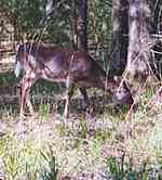
A large number of deer are in the cove, and if you
are lucky, wild turkey and black bear can be observed. You can always tell
if some interesting wildlife is near by the number of cars that are pulled
off to the side of the road with people standing about pointing and looking
through binoculars. On several of our drives through the cove, we have
counted over 200 deer and have seen several wild turkeys. Maybe on our
next trip we will spot a black bear.
Please do not feed the wild animals: They loose their fear of humans, become dependent on us for food and soon become nuisances and a threat to other visitors in their search for food. Remember - the animals are wild, and you can neveer be certain of how they will react toward humans. View them from a distance.
You've probably already noticed that there is no
entrance fee for the GSMNP. This is due to a clause in the Park's enabling
legislation. Other parks such as Grand Canyon and Yellowstone can charge
entrance fees of $20 per vehicle and earn millions of dollars in supplemental
funding as a result. Please consider making purchases at the Visitors Centers
where all proceeds go toward funding worthwhile projects in the Park. Additional
financial help is provided by the Great
Smoky Mountains Association and the Friends
of the Smokies organizations. Please consider joining these organizations
in their effort to help the Park. There are also donation boxes as you
exit the Cades Cove loop road.
For more travel links on the Smokies, visit our Smoky Mountains Page.
For a listing of publications on the Smokies that we have found to be helpful, check out the Lotz Travel Bookstore or use the box below to search Amazon.com for your own interests .
| The
Left Fork:
Little River, Meigs Falls, The Sinks, |
 |
Want to see a map of the GSMNP?
Check out the
National
Park Service digital maps web site
for maps of most of the National
Parks
Be sure to visit these
other Lotz Family pages:
All
photographs copyright 1997 - 2006 by the Lotz Family
Updated 1/22/2006