
 We
woke up at Doe Bay and decided to take the ferry back
to Anacortes and head down Widbey Island. We left Doe Bay at 8:00 am for the
ferry. Looking at our map of Orcas Island we had covered the whole island
with the exception of Obstruction Pass, which was on our way. The term 'pass'
seems to refer to the 'passage' of water it overlooks, rather than a 'mountain
pass.' There is suppose to be a small marina and campground here. We got on
the 9:00 ferry which stopped at Shaw Island before reaching Anacortes at 10:20.
Anacortes is on Fidalgo Island, which can be reached by car by two different
routes. From 1-5 via highway 20 coming from the north or Widbey Island crossing
the Deception Pass Bridge from the south. We checked out some more bookstores
in Anacortes and ate a late lunch at Gere-a-deli on Commercial Ave. This is
large deli that was quite busy earlier in the afternoon. They had two soups,
several salads and lots and lots of sandwiches to choose from. When we here
Friday night the place was packed. We discovered that Friday was the only
evening they were open for dinner and they served 'dinner,' not just sandwiches
on that night.
We
woke up at Doe Bay and decided to take the ferry back
to Anacortes and head down Widbey Island. We left Doe Bay at 8:00 am for the
ferry. Looking at our map of Orcas Island we had covered the whole island
with the exception of Obstruction Pass, which was on our way. The term 'pass'
seems to refer to the 'passage' of water it overlooks, rather than a 'mountain
pass.' There is suppose to be a small marina and campground here. We got on
the 9:00 ferry which stopped at Shaw Island before reaching Anacortes at 10:20.
Anacortes is on Fidalgo Island, which can be reached by car by two different
routes. From 1-5 via highway 20 coming from the north or Widbey Island crossing
the Deception Pass Bridge from the south. We checked out some more bookstores
in Anacortes and ate a late lunch at Gere-a-deli on Commercial Ave. This is
large deli that was quite busy earlier in the afternoon. They had two soups,
several salads and lots and lots of sandwiches to choose from. When we here
Friday night the place was packed. We discovered that Friday was the only
evening they were open for dinner and they served 'dinner,' not just sandwiches
on that night. 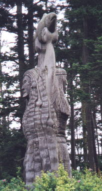
 After eating we headed south toward Widbey Island. Before crossing the Deception
Pass Bridge we stopped at Rosario Beach which had some nice views of the water
from several hills. There was also an impressive wooden sculpture of the 'Maiden
of Deception Pass' holding a salmon up in the air. Her face was carved on
both sides, but on one side she had just returned from the ocean with shells
and fish carved in her hair. A plaque explained the Indian legend about this
maiden. We continued south and pulled over just before the bridge. We walked
about 3/4 of the way across this bridge which was built in two sections, one
from Fidalgo Island to little Pass Island. The other from Pass Island to Widbey
Island. The view from the bridge is quite spectacular. We drove through the
Deception Pass State Park, the largest park in the state with over 250 campsites
and 300 picnic sites.
After eating we headed south toward Widbey Island. Before crossing the Deception
Pass Bridge we stopped at Rosario Beach which had some nice views of the water
from several hills. There was also an impressive wooden sculpture of the 'Maiden
of Deception Pass' holding a salmon up in the air. Her face was carved on
both sides, but on one side she had just returned from the ocean with shells
and fish carved in her hair. A plaque explained the Indian legend about this
maiden. We continued south and pulled over just before the bridge. We walked
about 3/4 of the way across this bridge which was built in two sections, one
from Fidalgo Island to little Pass Island. The other from Pass Island to Widbey
Island. The view from the bridge is quite spectacular. We drove through the
Deception Pass State Park, the largest park in the state with over 250 campsites
and 300 picnic sites.  Continuing
south on highway 20 we stopped at Widbey State Park which had a few picnic
tables and a beach. This park was too close to outskirts of the town of Oak
Harbor for us. It didn't take us long to find out there
wasn't a lot to do for entertainment in this town. The fact that it houses
a military base and a branch of the Western Washington University's Education
Department meant it's really a family sort of town. The one movie theatre
had three movies which were all PG. We found three Mexican restaurants to
choose from for lunchh. We finally ate dinner at El Cazador. The waittress
was nice and asked the cook to make Dale'slunch spicier.
Continuing
south on highway 20 we stopped at Widbey State Park which had a few picnic
tables and a beach. This park was too close to outskirts of the town of Oak
Harbor for us. It didn't take us long to find out there
wasn't a lot to do for entertainment in this town. The fact that it houses
a military base and a branch of the Western Washington University's Education
Department meant it's really a family sort of town. The one movie theatre
had three movies which were all PG. We found three Mexican restaurants to
choose from for lunchh. We finally ate dinner at El Cazador. The waittress
was nice and asked the cook to make Dale'slunch spicier.

 We
took Highway 20 south a few miles to the quant town of Coupeville, the oldest
town on the island and the second oldest town in Washington. This town is
full of 19th century Victorian homes and churches. We walked along Front
Street where most of the restaurants and pubs are. We ate lunch and bought
some bread at the Knead and Feed Bakery, which was a tiny little restaurant
which overlooked the water. Then we walked down to the Coupeville Wharf
where we found several giftstores, galleries and a bookstore. We got back
on Highway 20 going south. We turned off to go the Fort Casey State Park,
but the road was closed. Looking at the map we could have gotten there by
way of Coupeville but we didn't have time to backtrack. Back on Highway
20, which has now become Highway 525, we drove past Greenbank not realizing
it and turned off at Smuggler's Cove Road toward South Whidbey State Park.
There is only one way in and out of this park and the road seemed to go
forever. There were quite a few campsites at this park, a beach and lots
of trails. We liked Fort Ebey S. P. better than this park. Back on Highway
525 we drove through the town of Freeland which was orginally a socialist
utopian community founded in the early 1900's. It appeared to have a nice
mix of local businesses and tourist shops.
We
took Highway 20 south a few miles to the quant town of Coupeville, the oldest
town on the island and the second oldest town in Washington. This town is
full of 19th century Victorian homes and churches. We walked along Front
Street where most of the restaurants and pubs are. We ate lunch and bought
some bread at the Knead and Feed Bakery, which was a tiny little restaurant
which overlooked the water. Then we walked down to the Coupeville Wharf
where we found several giftstores, galleries and a bookstore. We got back
on Highway 20 going south. We turned off to go the Fort Casey State Park,
but the road was closed. Looking at the map we could have gotten there by
way of Coupeville but we didn't have time to backtrack. Back on Highway
20, which has now become Highway 525, we drove past Greenbank not realizing
it and turned off at Smuggler's Cove Road toward South Whidbey State Park.
There is only one way in and out of this park and the road seemed to go
forever. There were quite a few campsites at this park, a beach and lots
of trails. We liked Fort Ebey S. P. better than this park. Back on Highway
525 we drove through the town of Freeland which was orginally a socialist
utopian community founded in the early 1900's. It appeared to have a nice
mix of local businesses and tourist shops.
 Heading
south on 525 we turned off toward Langley, a small town with a collection
of art galleries, antique stores, thrift stores, tourist shops and restaurants.
This town was founded by a 15 year old boy in 1880. Taking Langley Road
back to Highway 525 we stopped at the Whidbey Island Vineyard and Winery.
Unfortuanately it was closed today, (open Wednesdays thru Sundays). Langley
Road turns into Cultus Bay Road when it passes Highway 525. We continued
on Cultus Bay Road working our way to Possession Beach which had beach access.
There were several residential areas with nice views of the water, one of
which did not look too friendly as a sign in someone's yard read 'No Public
Access to Beach, Keep Out.' Nearby several deer were nibbling on grass in
someone's backyard. The public Possession Beach Waterfront Park was quite
disappointing. Here there was a small beach, with a poor view of the water,
although it did have wheelchair access. We drove north to Clinton where
we would catch the ferry that leaves every half hour for Mukiteo and cost
$5.75. We got in the ferry lane and worred as to whether we would get on
the first ferry, as there were cars in front of us that had gotten through
the light and we were stuck on the hill sitting at a red light. But there
was no need to worry as the ferry never did fill up. We stayed near Mukilteo.
Heading
south on 525 we turned off toward Langley, a small town with a collection
of art galleries, antique stores, thrift stores, tourist shops and restaurants.
This town was founded by a 15 year old boy in 1880. Taking Langley Road
back to Highway 525 we stopped at the Whidbey Island Vineyard and Winery.
Unfortuanately it was closed today, (open Wednesdays thru Sundays). Langley
Road turns into Cultus Bay Road when it passes Highway 525. We continued
on Cultus Bay Road working our way to Possession Beach which had beach access.
There were several residential areas with nice views of the water, one of
which did not look too friendly as a sign in someone's yard read 'No Public
Access to Beach, Keep Out.' Nearby several deer were nibbling on grass in
someone's backyard. The public Possession Beach Waterfront Park was quite
disappointing. Here there was a small beach, with a poor view of the water,
although it did have wheelchair access. We drove north to Clinton where
we would catch the ferry that leaves every half hour for Mukiteo and cost
$5.75. We got in the ferry lane and worred as to whether we would get on
the first ferry, as there were cars in front of us that had gotten through
the light and we were stuck on the hill sitting at a red light. But there
was no need to worry as the ferry never did fill up. We stayed near Mukilteo.
250 miles today, 4300 total