Clouds
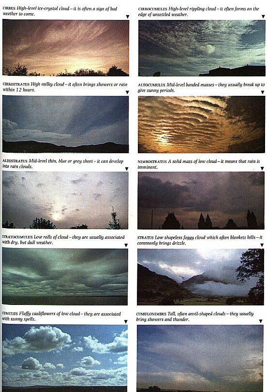
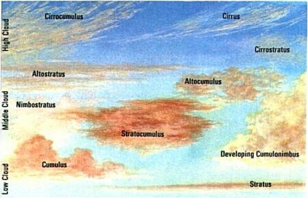
CLOUDS are masses of water droplets or ice crystals suspended in the air. When air rises, it expands and cools. Cool air cannot hold as much water vapour as warm air. Eventually the rising air cools to a temperature at which it can no longer hold all of its moisture in the form of vapour. The extra water vapour is deposited on small particles that are always to be found floating in the air - salt crystals, pollen, dust, etc - and it forms the water droplets or ice crystals that make up a cloud.
    Clouds have two distinct forms. Cumuliform (heap) clouds usually have a fairly level base with fluffy upper parts. Stratiform (layer) clouds usually appear in an even, unbroken blanket across the sky. Cloud forms are important in weather forecasting. The ten main clouds are described in the table below and also in the picture. Check out 'The Message in the Clouds' further down the page.
 
The different types of clouds are known by Latin names which describe their shape and height. These names are explained in the table below.
 

Cloud Types

Cirrus :
Delicate, white, detached, high clouds, with a fibre-like appearance. Its many forms include 'mare's tails'.
Cirrocumulus :
Thin sheet or patch of high cloud in the form of ripples or rounded small masses, often merged together. Sometimes produces a 'mackerel sky'.
Cirrostratus :
Transparent film or fibre-like, whitish high cloud. Frequently seen before a depression. It is generally the cause of a halo seen around the Sun or Moon (effects of ice crystals on light).
Autocumulus :
Greyish-white sheet or patch of medium-high cloud, with shading, made up of rounded heaps, often merged together.
Autostratus :
Greyish sheet of medium-high cloud, either fibre-like or uniform. Often produces the 'watery sky seen before depressions.
Stratocumulus :
Greyish-white sheet of low cloud, with shading, made up of rounded masses, often merged together.
Stratus :
Uniform, grey, low cloud layer, similar to fog. May envelop high ground.
Nimbostratus :
Grey, often dark, layer of cloud, sometines blurred by falling rain or snow.
Cumulus :
Detached, low cloud heaps, developing upwards; brilliant white when lit by Sun.
Cumulonimbus:
The thunder cloud. Dense, with upper portion usually flattened out in shape of an anvil; its low base may be very dark.

The Message in the Clouds
Clouds are the handwriting of the weather. They are formed when cooling causes some of the water vapour present in the air to condense into visible water droplets or ice crystals. In most cases the cooling is the result of the air rising.
    If cloud is deep enough and lasts long enough, some water droplets or ice crystals grow to produce raindrops and snowflakes large enough to overcome the rising air currents and fall as rain or snow. In temperate latitudes, much of the rain starts life as snow and melts during its fall to the ground. In very deep convective clouds, hail (frozen rain) may form instead.
    Cloud and rain are generally associated with low pressure systems. This is because low pressure systems occur in areas where a lot of air is rising - and cooling as it does so. In regions of high pressure, by contrast, the air is sinking towards the ground - warming as it falls. As a result, water droplets in the air evaporate into invisible water vapour, and the clouds formed from the droplets break up and disappear.
    There are ten main types of clouds and each carries its own message about the weather to come, details of which are shown in the above series of pictures.


This page hosted by Get your own Free Home Page