Photographs of Fire-Control Towers
of the Chesapeake Bay Harbor Defense Command
(Virginia Beach locations)
1941-1946

About Base-End Stations
About Base-End Stations
Sightings made through the optical instruments at base-end stations were coordinated by time-interval bells that rang synchronously throughout the entire system. Using this method, the location of a target could be determined from several towers at the same instant. Data from these observers, along with weather information, was telephoned on secure lines to bomb-proof plotting rooms. A primitive computer processed all of the incoming information and then provided artillery crews with aiming coordinates based on the predicted location of the moving enemy ship at the time of firing. Because the shells might be fired as far as 25 miles, the rotation of the Earth had to be taken into consideration when calculations were being made.
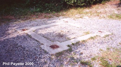

Stairway foundation to Granite Tower B (photo 1). N 36Ḟ55.350 W076Ḟ02.531 (USCGS)
Foundation to Granite Tower A (photo 2). N 36Ḟ55.455 W076Ḟ02.502 (USCGS)
The Tower C site is under the Club parking lot. N 36Ḟ55.515 W076Ḟ02.599 (USCGS)
Behind Tower A was the Map Control Station. N 36Ḟ55.455 W076Ḟ02.493 (USACE)
A switchboard room still stands behind the Tower B site.

The Casemate Tower built over the Mine Casemate at Fort Story.
It served Battery
Worcester, Battery Cramer or 226, and the minefield.
This tower was torn down before my visit in June 2007.
N 36Ḟ55.833 W076Ḟ01.866 (USCGS)


This tower was located at 67th Street, just off Atlantic Avenue, between Fort Story
and the main resort area of Virginia Beach.
This was known as Parcel C - Tower A. N 36Ḟ53.605 W075Ḟ59.281 (USCGS)
This tower was torn down July 2003.
MORE PHOTOS - click here
Two azimuth instrument pedestals from this tower are now on display at Ft Mott, NJ (Battery Krayenbuhl & museum).
Tower B was dismantled in 1960. N 36Ḟ53.574 W075Ḟ59.283 (USCGS)
These towers served Fort Story and Fort John Custis.

Part of the foundation to this house is of Tower A at the location
known as Hollies off 46th Street in Virginia Beach
(the portion topped with bricks). N 36Ḟ52.233 W075Ḟ58.945 (USCGS)
This tower served Fort Story and Fort John Custis.
Tower B was located on the other side of the house. N 36Ḟ52.431 W075Ḟ59.103 (USCGS)
Also near this location was a radar tower and two searchlights.
SCR - N 36Ḟ52.428 W075Ḟ59.047
SL 5 - N 36Ḟ52.412 W075Ḟ59.043, SL 6 - N 36Ḟ52.478 W075Ḟ59.064

Sand Bridge Tower B was dismantled in 1993. N 36Ḟ44.876 W075Ḟ56.932
Tower A was dismantled soon after WW2. N 36Ḟ44.915 W075Ḟ56.958 (USCGS)
Both towers served Fort Story and Fort John Custis. The foundation to both towers
still remain, but the Tower A site is not easily photographed because of the
overgrowth.

The aerial photograph is of the Sandbridge parcel that contained both towers
[a diagonal road leads to it in the woods behind the residential area].
Note: There were several more towers, but they have been dismantled.
The other locations were (listed from north to south):
North Buckroe (1 tower at Buckroe Beach, Hampton) N 37Ḟ03.254 W076Ḟ17.065 (USCGS)
Chesapeake Beach (1 tower near US 13) N 36Ḟ55.169 W076Ḟ08.084 (USCGS)
Emerson or Parcel B (2 towers off 72nd Street)
N 36Ḟ53.801 W075Ḟ59.600 (approx), N 36Ḟ53.795 W075Ḟ59.598 (USCGS)
Rifle Range (3 towers near Camp Pendleton) N 36Ḟ49.445 W075Ḟ58.622 (USCGS Tower A),
N 36Ḟ49.400 W075Ḟ58.603 (USCGS Tower B), Tower C site undetermined
Little Island (1 tower at Little Island Park) approx N 36Ḟ41.544 W075Ḟ55.375
In addition:
120th St. Seacoast Radar Tower (off today's 82nd St) approx N 36Ḟ54.407 W075Ḟ59.700
Rifle Range Searchlights 3 & 4 (at Camp Pendleton) N 36Ḟ48.949 W075Ḟ58.185 (USCGS "Pendleton N"),
N 36Ḟ48.924 W075Ḟ58.178 (USCGS "Pendleton S")
Dam Neck Searchlights 1 & 2 (at Dam Neck Navy Base) approx N 36Ḟ46.854 W075Ḟ57.432
Ocean View Searchlights 22, 23 (previously 20) (Ocean View Beach in Norfolk) approx N36Ḟ56.980 W076Ḟ14.582
Side note: In Norfolk, Sarah Constant Beach, Ocean View Elementary School and the
interchange area of Tidewater Dr. and Ocean View Ave. was the site of the Navy's
Willoughby Reservation (N 36Ḟ57.555 W076Ḟ15.523).

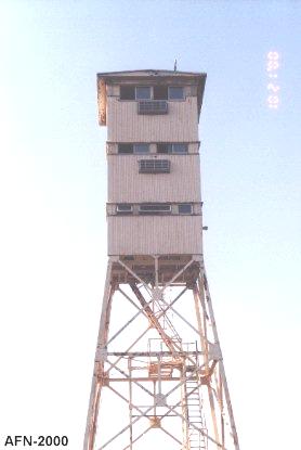
This tower is believed to be the Searchlight Controller Tower and is
still used by the Navy at the gunnery range.
N 36Ḟ46.810 W075Ḟ57.448
 |
|
