![]()
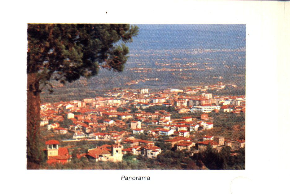
The Florence Lake and the Golfolina
The most important phase in the geological history of the territory extending from Lastra to Signa began at the end of the Tertiary period. Situated between the Appenine formation to the north and a hilly region to the south, the Montalbano Poggiona ridge stretches from Florence to Pistoia for about 40 km, forming a basin whose lowest part crorresponds to the rift valley af the foot of the Appenines. The coastline runs along the south side of the hills. This depression filled with water from the mountains, and to an even greater extent with tbe waters of Mugello Lake and the central Armo valley, which entered from the east though the incisa fissure. To the southwest, an outlet flowed from the lake to the sea through the Golfolina, gradually becoming deeper via a continuous process of erosion until the lake dried up. The waters from the Appenine slopes drain off info the Arno which flows into the basin through the Incisa, and out via the Golfolina. 'l'he Golfolina consists of a series of meanders boxed in by sheer walls of rock. It extends from Brucianesi to Montelupo for a distance of approximately 10 km. The inaccessability of the area, which is still very picturesque, made it extremely difflcult in centuries past to carry out maintenance work on the Pisa road which, at this point, runs along the left bank of the Arno. From the Renaissance onwards, the Golfolina and that particular stretch of the Armo were the subject of a great deal of scientiflc enquiry. Leonardo was the first to put forward the hypothesis of an ancient lake, even though this has only come to light in recent times. And so, the first person to produce conclusive arguments regarding the geological development of this area was Giovanni Targioni Tozzetti.
The Etruscans
The Etruscan were theflrst inhabitants of the Golfolina territory ofwhom traces have been found, and il was during this period that the Amo began to be used as a waterway to the Tyrrenhian coast. This role was identifled by Lami with the supposition that Florence, beyond which the Arno was not navigable enjoyed great prosperity during Etruscan times. The theory that Florence was the port of Fiesole, which then developed to the point that it outgrerew the latter, has not been conflrmed to any great degree; while the antiquity of Artimino, whose citizens were the Arteminos referred to by Cicero in a letter to Atticus, appears to be far more well-founded. This would apparently confirm the theory that Porto di Mezzo was once an Etruscan river port; also, if the highway from Arezzo running through the hills south of the Arno arrived here, the waterway and road junction was of unquestionable importance for the surrounding territory, in whicb existing settlements were developed along extremely important routes. There are at least two other place-names of Etruscan origin: Carcheri and Falterona, whose position in the network of routes would lead one to suppose that other settlements are of similar origin. Etruscan finds discovered between Monte Cacioli and Castagnolo in the eighteenth century would appear to confirm this hypothesis.
The Romans
Durign the period of roman occupation, the role assumed by Pisae and Florentia Tuscorum crontributed to the development of an important network of routes which followed the origina Etruscan layout to a certain extent. Roads running perpendicular to the ridge were given precedence, and the stretch of road parallel to the Amo became part of the consular road between Florence and Pisa, the opening - or, at least, the repair - of which can be traced to the lst century B.C. The Arno reached the height of its strategic importance in the regional network of routes during tbe Middle Ages, while the Pisa road went into a long period of decline when maintenance was stopped after the fall of the Roman Empire. At the end of the fourth century, in fact, there is evidence of an alteative route through the hills, the existing Vccchia Pisana road, and it is amongst these hills that we find settlements with Roman toponyms: Malmantile, Bracciatica, Marliano and Gello. Lamole, situated on the banks of the Arno, also has a Roman name which means "marshy area". These small settlements mostly sprang up in farming areas, but there were also other near the river and the stone quarries.
The Middle Ages
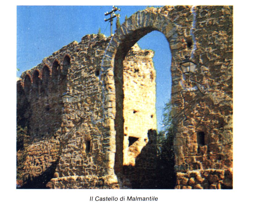
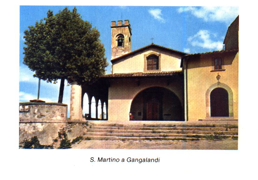
In mediaeval times the hill route, which passed through Malmantile, became increasingly imprortant. The most ancient stretch of this road was possibly that which led to the Etruscan town of Falterona. It was thanks to the nearness of Florence that a coaching house was built along this altemative Pisa route, on a level with the Rimaggio torrent. A small community grew up around it, which was afterwards to become the ogirinal capital of Lastra. Later on, a similar settlement was to spring up further down the hill when the mercatale (marketplace) had become wellestablished. The Malmantile coaching house was also built in the hills, and was directly related to the function of the road. On the plain, the floods and the uncertain position of the "islands" in this stretch of the Arno made the creation of permanent settlements difficult, despite the fact that flooding rendered the land extremely fertile and, therefore, attractivc to farmers; on tbe other hand, the difficulties encountered in the hills were caused by the thickly-wooded areas and the water supply. Consequently, the foothills proved to be the ideal place for settlements which sprang up along the Pisa road, from Florence to the Golfolina, thanks also fo the possibility of moorings offered by the rocky walls on either side of the Arno. A number of settlements sprang up here, consisting of either small communities or a few scattered houses, the inhabitants of which made their living by farming or by doing work connected with the river. A number of churches acted as points of reference for these settlements, the oldest of which was the Church of S. Giuliano in Settimo, which was also a parish church. Near S. Giuliano stands the Abbey of Settimo, which was firsf occupied by the Benedictine order and later by the Cistercian order, and also the castles of Monte Cacioli and of Monte Orlando, which provide further evidence of the economic prosperity and population increase in this area during that period. The only parish in the communal territory was that of S. Ippolito. lt was located on the banks of the Pesa, as was the village of Ginestra, which stood out from the other settlements and was situated at the ford where the road leading to Montespertoli and Carcheri begins. The churches which sprang up along the Pisa road after the year 1000 became vital centres of community life. The most important of these was the Church of S. Martino at Gangalandi, as is evident from its size and from the chapter of the canons, which stood on a rise amongst the hills that overlook the Arno, opposite Signa. The Church of S. Martino came under the parish of S. Lorenzo and S. Giovanni Battista at Signa, as did all the parishes on the left bank of the Amo. Signa was first mentioned in a document in 978. It came under Pistoian rule shortly after the year 1000, and presumably there were fortiflcations on the hill. Florence gained control of the town in 1124, and it is referred to by Davidshon as one of the six centres of the comitatus (county) of Florence and Fiesole. The importance of the Arno's shores, is verified by the large number of contracts stipulated by notaries, who carne there for that speciflc purpose. There were another three fortifled towns, built in the ninth century, on the right bank of the Arno: Carmignano, Artimino and tbe castle of Capraia. The castles of Monte Cacioli and of Monte Orlando - above Gangalandi - controlled the left bank from then on. From the twelfth century onwards, the disputes that arose between Florence and the feudal lords of the territory resulted in many fortifications being dismantled, including the castle of Gangalandi, which was razed to the ground in 1107 and of Montecacioli, which was destroyed in 1113. In 1124 the Florentines gained control of Signa whose fortifications remained intact, thanks to its strategic position. After Signa had been taken, the territory to the west of Florence was extended. A bridge was built over the Arno. which was the only one between Florence and Pisa for a long time. The end of the thirteenth century marked the beginning of a period of political unrest, which was to last until the latter half of the thirteenth century when these territories began to experience considerable economic expansion and population increase. The importance ofthe Arno as a waterway for the area between Lastra and Montelupo was confirmed by the building of three ports, each for a different purpose: Porto di Sotto, Porto di Mezzo and Ponte a Signa. The administrative changes that took plce in 1250 and divided the territory of florentine republic into 96 parishes, created the necessary structure for the founding of the leagues immediately afterwards. The leagues constituited the official recognition of a changing reality: Gangalandi was a case in particular in that it was the headquarters of the league of the same name and, therefore, was no longer respomible to Signa's civil service; however, it still came under the parish of S. Lorenzo and S. Giovanni Battista. During the fourteenth century, outbreaks of the plague and of war brought development to a standstill and the territory reluctantly became an arena for the disputes between Castruccio and the Florentines. The Florentines were only able to consolidate their power after his death, when they began to construct permanent fortiflcatiom in various parts of the territory.
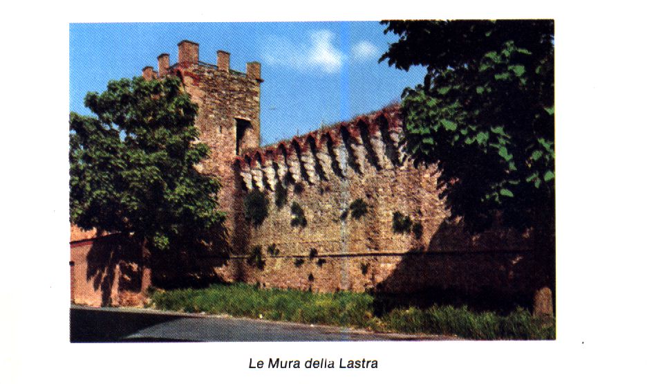
We must presume that individual fortiflcations already existed prior to the construction of the city walls. There is no actual record of the extent of earlier building, in spite of the fact that the various stages were carefully documented. What little information there is concerns lhe church of S. Maria and the division of the area around the Hospital of Sant'Antonio in which Brunelleschi possibly had a hand. The amount of time taken to build the walls - from 1400 to 1427 reveals that the Florentines, apart from their obvious need to defend themselves against the Pisans (who were actually defeated in 1406), also wanted to protect the mercatale, located between thc hoispital and the actual town, and to encourage people to come back and live within the safety of the city walls. The wal1s that were built at Malmantile during the same period, and which made similar provisions, would appear to have had more of a strategic purpose, in that the coaching house and the actual village remained outside. The antiquated structure of these walls would lead one to suppose that they were not built solely for economic and tactical reasons but to defend the great city of Florence, rather than actual the Florentine state. The capital, tberefore, assumed a new role by setting itself up as the urban and intellectual centre of an ever-widening territrory, to which it had brought peace and unity.
The walled-town of Lastra in the fifteenth and sixteenth century
At the beginning of the fifteenth century, there was widespread poverty in the walledtown of Lastra and the surrounding countryside, which were repeatedly ravaged by famine and epidemics. The land register which had just been instituted by the Florentine Republic (1427) describes the general situation as quite depressing - a situation that according to information gathered on episcopal visitations still existed more than a century later! In 1529 Lastra, which was still the only gateway to the west of the Florence plain, fell to the imperialists, who then held Florence under siege in order to impose a Medicean Seigneury. The walled-town of Malmantile, on the other hand, was passed over. It was most probably already in a state of semi-abandon, in which it seems to have remained for the entire seicento. Under Medici rule, the lack of involvement on the part of the homines in the country and throughout the territory in Florentine political life, produced positive results that were manifest in economic growth and expanding trade: the number of craftsmen increased, new buildings were erected and more roads were built. The military function of the walls was eliminated at this point and increasing attention was given to the network of roads, to the extent that the GueIf Chancellors organized the mapping of every single road in the Florentine territory at the end of the sixt~enth century. The Arno still continued to be a source of worry and many studies were embarked upon to avert the difficulties caused by periodic flooding and the silting up of the river bed, which created navigational hazards.
The territory of Lastra in the seventeenth and eighteenth century
During the eighteenth century, episcopal visitations once again provided far from reassuring news about the living conditions in the territory of Lastra, with problems related to the Arno requiring constant attention. The walls of the regional capital were mostly in ruins. A number of the towers had already been sold to private citizens, and the , "privatization" of the walls was to continue until the end of the nineteenth century. Significant changes were taking place, which once again involved the network of roads that had always been of great importance. Many improvements were made to this network throughout the eighteenth century. In the territory of Lastra the stretch of road between Ponte a Signa and Montelupo, which ran parallel to the Amo, was reopened, and the Pisa road was improved from start to flnish. This road no longer went through the walled-town but followed fhe walls - the old route - to arrive at the coaching house, after which the new stretch joined up with the old road that led to Malmantile. For this reason fhe centre of Lastra, which lay within the walls, remained untouched by the new development. If on fhe one hand, this has resulted in the ancient town remaining intact, on the other hand, if has created a situation similar to that of other Italian towns, but in the reverse sense, where there is an ancient hill-town with a modem settlement lower down on the plain; the situation is further complicated when old and new have to exist within the same walls. The weekly market that was set up in 1779 was one of the many that were springing up in most communities at that time, and certainly not the product of further economic growth. This is confirmed by the Cronache del Convento di Santa Lucia (Chronicles of ~he Santa Lucia Convent), which state that the market was not at all successful The compilation of a list of "paupers" (at the end of the 1700s) and the information contained in the above-mentioned Chronicles, give us an idea of just how depressed the area was at that time. Nevertheless, the roads were checked regularly. A report was written in 1803, which not only describes every inch of the Pisa road but also the connected works, including maintenance. This makes it an extremely interesting document.
The historical centre of Lastra from the nineteenth century until the present
A great deal of attention was given to the maintenance and restoration of public buildings throughout the nineteenth century. The most important works undertaken were own the restoration of Teatro La Fenice (1828), the Pretorian Palace (1830) and the Town Hall (1866). The premises of the Misericordia (Misericorde) were extended in 1896. The public square was restored to the people in 1836, which constituited an extremely important gesture. The square had functioned as a market until the cinquecento, after which it had been bought by private citizens. The above operation was completed by the Comune's reacquiring one of the towers, the Portone di Baccio, which then bccame the local prison (1868). More attention was given to fhe dangerous sanitary conditions in the historical centre rather than to the appearance and ornament of the buildings, as is shown by the studies effected to protect the town from flooding and for the draining of the marshes, and the Regolamento d'Igiene (Sanitary regulations) issued in l874. Betweeb the end of the last century and the beginning of the present one, therefore, a number of projects were undertaken mostly within the city boundaries, which were later extended by further development. In 1923, the first new road was opened (named after Pirro Nenciolini, the civil engineer who built it, and now known as Via G. Matteotti), which bisected the angle formed by the Pisa road and the old stretch of this same road leading to Malmandle. During this same period, local craft industry (terra-cotta, straw, footwear) was developed for which the capital became a natural reference point in this new period of economic growth. The changes that took place within the walled-town are evidence of this, even though it no longer played an active role, in tbe sense that tbe only craft practised in tbe town was the manufacture of trimmings for hats. This latest economic "boom" resulted in the premises of two associations being built: the Società Filarmonica G. Rossini (G. Rossini Philharmonic Society) and fhe Circolo Ricreativo G. Carducci (G. Carducci Social Club), fhe former being located outside the walls and the latter within, but at the upper end of the town. The lower part of town, on the other hand, fell into a decine. This became increasingly evident, with coffee houses closing one after another, and it was not even possible to arrest the process by holding a weekly market. The opening of a new access road within the walls, running from the south-east comer of the town to the market square, was discussed for a long time but never projected. The Second World War came to an end in the summer of 1944, and left profound "scars" on the entire territory of the Comune. Retreating Germans blew up the old coaching house, amongst other things, at Malmantile. They mined two towers at Lastra: the Florentine Gate and the Portone di Baccio. Ponte a Signa was the worst hit, with the mediaeval town being demolished by British and American bombing, and the bridge across the Arno being destroyed by the Germans. They even mined the GoIfolina mass, which remained virtually intact. Plans for rebuilding Ponte a Signa were drawn up by the architect Primo Saccardi. After the state of emergency had ceased, there was a complete lack of new ideas regarding the development of the regional capital. A direction was followed that had already been anticipated by the building of a section of the present Via 1 Maggio south of the Livomese road; and which was confirmed by a government project that was realized shortly afterwards: three case Fanfani estates (provided for by the Fanfani Law) located in the area between the Guardiana gully, the hills of Poggio Vittorio, and Massolina. The new development lacked method. No studies were carried out to find an efficient way of connecting the new centre to the ancient town. There was not even a plan of alignment! The new development was in fact nicknamed "Korea", even though it was right on the doorstep.
Mythology, literature, society
Hercules and the Golfolina: It is said that Hercules, struck by the beauty of the place, chose to settle here with his son Etrurian (and that the people he govemed were called Etruscam); and it was he who began the drainage of what was to become the Florence Plain. This myth firsf appeared in literaryform during the roman period. The hero tamed a wild stretch of land bounded by the unknown - the sea - by marking out a specific area and determining the conditions for its use. Hercules is said to have played a similar role in the founding of Barcelona.
St. Ambrose and Malmantile: The story goes that the Saint stopped at a villa situated in the hills, between the Arno and the Pesa, on his way to Rome. Upon leaving, he hurled a malediction Male Mantile! (Accused Mantile!) at the house - and this is how the town got its name. This episode is one of a series of minor exploits attributed to St. Ambrose. Apart from the fact that the Saint's words can be interpreted in various ways, the episode is also an indication of how Christianity, which was becoming increasingly widespread thanks to the efforts of the Bishop Zanobi of Florence, was already wellestablished in the Florendne countryside.
Malmantile lives again: Malmantile was once again acclaimed in the mid-seventeenth century when the Florentine painter Lorenzo Lippi found inspiration for an epic poem in the walled-town, even though it was then in a state of semi-abandon. Lippi, an enthusiastic observer of the traditional elements of rural life, dreamt up a mock-heroic tale of chivalry, a story set somewhere in the Middle Ages in which Malmantile was the contested prize. Lippi became so carried away with his epic poem that it rambled on for 7000 verses! The work began well but later the language became over-elaborate and was punctuated with local dialect, which was then almost obselete - a fact confirmed by many philological sfudies of the period. The poem was published in 1676 and became a "best-seller", as is evident from the numerous editions printed, including one printed in London. The entire poem is, in spite of everything, an interesting testimony of the vital genius loci of Malmantile. This was the last story the walled-town was to inspire before modem development began.
Modern literature and social life: During the nineteenth and the present century, literary works impired by the people of Lastra and their rural world, were characterized by an artiflcial style and idealistic viewpoint. At best they were a reconstruction of the past, devoid of fantasy. The most representative work is a novel entitled Signa. by the Englih writer Louise de la Ramée, better known as Ouida, which was published in 1875 and translated into ltalian the following year. The radical changes that were already evident at beginning of the nineteenth century resulted in sociologics occupying themselves with preserving age-old traditions. Angelo De Gubematis and his son, Alessandro, were in Calcinaia at the time, where they produced Le tradizioni popolari di Santo Stefano a Calcinaia in 1904, a collection of stornelli, rhymes and short stories; however, most of these were common to the entire Florentine ferritory After the Second World War, a recession began which gradually degenerated into the crisis which now besets the surviving associations. Likewise, the traditional structure of the parish is undergoing a complete metamorphosis, which would appear to be just beginning.
(Translated by Susie White)
![]()
this page hosted by ![]() get your own free home page
get your own free home page