 | ||||||
| Articles | Projects | Resume | Cartoons | Windsurfing | Paintings | Album |
Musqueam Salmon Stream
Restoration Project

Water Quality Analysis Project 1997

Site Location
Map of the Musqueam-Cutthroat Drainage Basin:

Map Reference (Page, 1993)
Map of the Test Site Locations:

Map Reference (Page, 1993)
Test Site Descriptions:
The Musqueam-Cutthroat Creek System is in the heart of Vancouver. The creek system originates in the Pacific Spirit Regional Park, and flows through the park forest, residential areas, two golf courses, and into the Fraser River delta to the Pacific Ocean.
The selection of sample sites must be carefully designed to use the available resources as efficiently as possible and yield the most useful information. This includes the person hours of the field team, the materials consumed for the tests, and the laboratory analysis. The sampling program strives to detect differences between upstream and downstream, and between Musqueam and Cutthroat streams. The selection of sites also monitors certain hot spots, such as specific culverts, to target potential point sources. The baseline data provides important background information for comparison should there be an event such as a fish kill.
The sample site locations described below were monitored from 1995 to 1997. A good sampling regime modifies site locations and there have been some minor changes since then in response to the implementation of restoration phases on the creek system.
Site 1: Musqueam Creek in Pacific Spirit Regional Park:
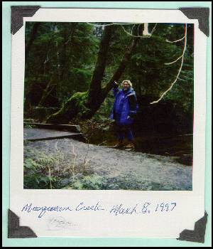
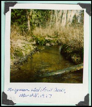
Site one, on Musqueam Creek in the heart of the Pacific Spirit Regional Park forest, provides a profile of the natural state of Musqueam Creek before it enters residential land use areas. This site is illustrated in Figure 1, and in the Musqueam Water Colour painting by Waterose.
Site 2: Musqueam Creek in Musqueam Park:
Site two, on Musqueam Creek in Musqueam Park, provides a profile of Musqueam Creek just after it enters the residential land use area. Site two is located just upstream of the salmon hatching and incubation containers which are illustrated in Figure 2 below.

Site 3: Cutthroat Creek Culvert at Salish Drive:
Site three, on Cutthroat Creek under Salish Drive, provides a profile of Cutthroat Creek before it enters the main culvert that tunnels underneath Salish Drive. This is illustrated in Figure 3 below as the larger culvert on the upper portion of the image.

Site 4: Cutthroat Creek Small Side Culvert at Salish Drive:
Site four, on Cutthroat Creek under Salish Drive, provides a profile of the water quality as it leaves the small culvert adjacent to the main culvert. This small culvert is illustrated above in Figure 3 in the lower portion of the image. This culvert is identified as an area of concern because during the dry summer season, the water from this culvert supplies approximately half of the water for Cutthroat Creek. This site is a known location for reported fish kills, and peculiar odours. The objective is to identify any noticeable changes or differences in water quality that may be due to groundwater infiltration from the adjacent residential area that differ from the water quality of the flow from the main culvert in site three. It is possible that deleterious substances, other than nutrients, originate from the surrounding residential areas such as water drained from swimming pools.Site 5: Musqueam Creek Culvert East of Crown Street
Site five is located at a small culvert that flows into Musqueam Creek east of Crown Street just above the confluence of Musqueam and Cutthroat. This culvert is of concern because it may be cross connected to urban domestic sewage systems which would increase the concentration of nutrients and other substances that may be harmful to the fish habitat. The water temperature is noticeably warmer at this culvert compared to the other site locations.
Site 6: Musqueam Creek East of Crown Street above Confluence
Site six, on Musqueam Creek just above site five, provides a comparison of the water quality parameters between the natural stream and the flow from the culvert. This site also provides a comparison between the upstream sites described above. This site is located just above the confluence of Musqueam and Cutthroat which is illustrated in Figure 4 below. Cutthroat is on the left, and Musqueam is on the right of the image.
Other Potential Sample Sites:
The addition of new sampling sites is limited only by the available resources. Ideally, there could be additional strategic site locations that could provide greater details for comparisons along the creek system to determine the impacts of different anthropogenic activities such as residential development, commercial development, and recreational activities.
These could include:
- Cutthroat Creek above, or north of, South West Marine Drive. This would provide a water quality profile of this stream prior to entering the Shaughnessy Golf Course. This could be compared to data from site four to examine potential inputs from this golf course. It would also provide a good comparison to data from site one on Musqueam Creek in the forest.
- Cutthroat Creek just above the confluence of the two streams. This would provide a more complete water quality profile of Cutthroat, upstream and downstream, and could be compared to the Musqueam Creek data at site six.
- Cutthroat Creek and Musqueam Creek below the Confluence Point. This would provide a water quality profile of the combined streams just before they flow into Musqueam Village.
- Combined Creeks at 51st Avenue below Musqueam Village. This would provide a water quality profile that could be compared to the previous site to determine if there are significant inputs from the commercial Musqueam Village area. It would also provide a useful profile upstream of the Musqueam Golf Course.
- Combined Creeks at entry to Musqueam Slough. This would provide a water quality profile that could be compared to the previous site to determine if there are significant inputs from the Musqueam Golf Course.
- Introduction
- Site Location: Maps and Graphics of Basin and Sample Sites
- Field Water Chemistry Tests
- Summary
- Water Testing Cartoons on Musqueam Creek by the Waterose
were taken March 8, 1997
by the Waterose.
Next: Water Chemistry Tests
Index of Musqueam Creek System Topic Links


 email Waterose
Please Sign My Guestbook
Please View My Guestbook

| Articles | Projects | Resume | Cartoons | Windsurfing | Paintings | Album |
 | ||||||