
Here too lies the worlds largest non-arctic glacier system, the Siachen. Rising from the dizzy heights of the
Karakorum in the northwest, in the region of Sia Kangri, the Siachen starts it's 90 kilometer long journey to
the Nubra headwaters. Enroute, the Siachen is joined by the Shelkar Chorten and Mamostang glaciers, which
in turn are formed by numerous feeder glaciers. Thus it is that almost 14 moraines ride the surface of the great
Siachen.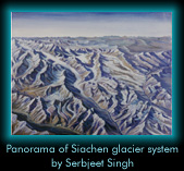 To the east of the Siachen is the Rimo glacier group. The North, Central and South glaciers sprawl on an
almost level roof...... between 6000 and 7000 meters above sea level. All three glaciers have between them
almost 700 square kilometers of ice which is, at places, almost a 100 meters thick. It is from this enormous
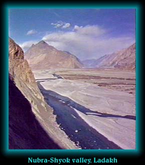
mass of ice that the Shyok takes birth. Thus the Siachen glacier empire contains about 2000 square kilometers
of ice surface and almost 200 cubic kilometers of ice.
To the east of the Siachen is the Rimo glacier group. The North, Central and South glaciers sprawl on an
almost level roof...... between 6000 and 7000 meters above sea level. All three glaciers have between them
almost 700 square kilometers of ice which is, at places, almost a 100 meters thick. It is from this enormous
mass of ice that the Shyok takes birth. Thus the Siachen glacier empire contains about 2000 square kilometers
of ice surface and almost 200 cubic kilometers of ice.
 The lakes of Ladakh may be left overs of the ancient sea that once covered Ladakh and Tibet, or so some
eminent goelogists have argued. Primarily drainage basins for the surrounding higher country the water is salty
and brackish. Pangong Tso, across the Changla pass, from Leh is only 8 km wide at it's broadest but is an
amazing 134 kilometers long bisected by the international border between India and Tibet. Most of the fresh
water inlets into the lake are towards the Tibetan end.
The lakes of Ladakh may be left overs of the ancient sea that once covered Ladakh and Tibet, or so some
eminent goelogists have argued. Primarily drainage basins for the surrounding higher country the water is salty
and brackish. Pangong Tso, across the Changla pass, from Leh is only 8 km wide at it's broadest but is an
amazing 134 kilometers long bisected by the international border between India and Tibet. Most of the fresh
water inlets into the lake are towards the Tibetan end.
 Mahseer