| Arlington Houses |
| Falls Church Houses |
| Loudoun Houses |
| An Old House Gets A New Lease On Life |
| Open To The Public For Tours |
| Annual House Tours |
| Sears Houses |
| Ā Home |
| Ā In The Civil War |
| Ā Biking |
| Ā The Railroad Remembered |
| Ā Parking |
| Ā Running |
| Ā What's New? |
| Ā Maps |
| Ā Walking |
| Ā In-Line Skating |
| Ā Old Towns On It |
| Ā Nature Centers and Museums |
| Ā Masonry Culverts and Trestles |
| Ā Railroad Photos |
| Ā Old Houses |
| Ā African- American Sites |
| Ā Equestrian |
| Ā Wildlife |
| Ā Bike Commuting |
| Ā Camping |
| Ā List of Photos Of It In Libraries |
| Ā Water Fountains |
| Ā Train Stations |
| Ā Railroad Suburbs |
| Ā Falls Church |
| Ā Dunn Loring |
| Ā Vienna |
| Ā Herndon |
| Ā Sterling |
| Ā Ashburn |
| Ā Leesburg |
| Ā Waterford |
| Ā Hamilton |
| Ā Purcellville |
| Ā Round Hill |
| Arlington |
| Falls Church |
| Dunn Loring |
| Vienna |
| Reston |
| Herndon |
| Sterling |
| Ashburn |
| Leesburg |
| Waterford |
| Hamilton |
| Purcellville |
| Round Hill |
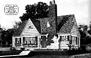
Mile 7.5 Sears house, Buckelew Drive (descend twenty feet from Shreve Rd crossing on trail,

|

|
|
| house just west of western border of Falls Church City. Sears Verona Model. |
Idylwood, a neighborhood in Fairfax County
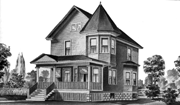
Mile 7.9 Sears house, Virginia Lane (just west of the bridge over I-66,

|

|
|
| Virginia Lane house; Sears Crescent Model. |
Dunn Loring, a neighborhood in Fairfax County
A walking tour of Dunn Loring.Mile 8.8 at Sandurg Street -- Taylor House, corner of Sandburg and Park Streets. 1887. This large frame house served as a grocery store for the soldiers who were training here at Camp Alger during the Spanish American War. The store room is now the living room. Among the thousands of soldiers was a young private from Illinois, Carl Sandburg. Sandburg Street is named after him. Visible from trail.
Mile 8.8 at Sandurg Street -- North Park Street, facing trail 1889. This two-and-one-half story frame house was one of four built by the Loring Land and Improvement Company before it went bankrupt. Visible from trail. North on Sandburg Street one-half block, right on N. Park Street one-half block.
Mile 8.8 at Sandurg Street -- Poole House, S.E. corner of Sandburg and Iliff Streets. c. 1890. Visible from trail.
Mile 8.8 Dunn Loring -- Crescent Model, 1924
|
|

|
|
| Crescent model |
Mile 9.25 Corner of Idylwood and Gallows Roads, The Black House also known as The Goat Farm, 1912 Note barn and other farm structures in back yard. Still owned by the Black family.
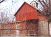
Mile 9.25 2400 Sandburg Street, 1887-1889 had a still during Prohibition. Note the large red barn in back, windmill, too.
Mile 9.25 Corner of Sandburg Street and Idylwood Rd. 1895-1896
Mile 9.25 7930 Idylwood Road, Shreve House1913. Lumber to build house arrived on the railroad. The carpenter earned $2 per day to build the house.
Mile 9.25 2422 Sandburg Street, Porter House, 1913-1914
Town of Vienna, in Fairfax County
Mile 10.2 -- at Cedar Lane. Magee House, 2382 Cedar Lane. c. 1870. The first owner of this house, McGee or Magee, owned all of the land between what is now the beltway and downtown Vienna. He sold off part of it to the developers of Dunn Loring.Mile 10.25

The Wedderburn family wants to sell Midgetville -- eight overgrown acres along the Washington & Old Dominion trail in Vienna.
Westbound, before reaching Vienna, you pass wooded land on the west side of Cedar Lane. This is Wedderburn, a flag-stop on the old railroad, now proposed to be developed. Read about it in The Washington Post here
A somewhat gloomy old house next to the trail, this house was built as part of a conference center owned by the Grange, an organization promoting agricultural benefits. Later it might have been part of a summer resort run by Charles Wedderburn. Had its own flag stop, "Wedderburn," on the railroad. visible from trail
Mile 11.5 -- at Park Street. Rippey/Moreland House, 401 Park Street SE, southwest corner of Park and Cherry/Mill Streets SW. c. 1908. Turn south on Park Street, one-half block; visible from trail
Mile 11.8 -- at Maple Avenue. Hollenbeck House, 112 Glyndon Street NE. 1908. This house was moved back from where the Shell gas station is now. Turn east on Maple Ave., three blocks; turn left on Glyndon St.
A guided tour, with map, is available for the half-dozen houses, below. Mile 11.9 at Church Street -- Bowman's Hall/Boulton's Store, corner Church and Mill Streets c. 1894 Now the Pennywise Thrift Shop, this store has seen service as a post office and general store. Upstairs is a hall now used by the Masons. It was formerly a dance hall, school, and meeting place of both the current events club and political parties. Go past historic Freeman House on Church one block.
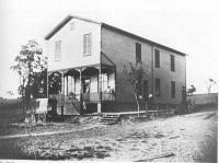
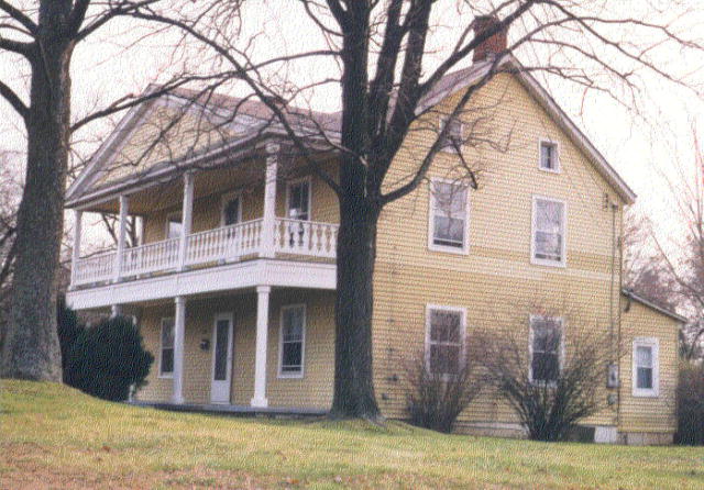
Mile 11.9 at Church Street -- Freeman House, Church Street 1859

|
|
| Freeman House, Mile 11.8 |
Mile 11.9 at Church Street -- Vienna Fortnightly Library, 122 Mill St. 1897 behind Freeman House; open first Sunday each month, 1-5 p.m.
Mile 11.9 at Church Street -- Berry House, NE Corner of Park and Church Streets NE 1898 on Church Street, go three blocks beyond historic Freeman House
Mile 11.9 at Church Street -- Leith House, 135 Park Street NE c. 1900 A doctor who made house calls in his horse and buggy, Dr. Leith had a barn, since demolished, which stood behind this house. Now "Cook Photography" occupies this house. on Church Street, go three blocks beyond historic Freeman House
Mile 11.9 at Church Street -- Barringer/Staats House, 340 Glyndon St. NEc. 1900-1907 The construction of the houses indicates primitive lumber preparations, including hand-hewn poles for rafters and logs flattened on one side for floor joists. on Church St., go four blocks beyond historic Freeman House; turn left on Glyndon St, two blocks; house on left.
Mile 12.0 at Ayr Hill Street -- Vienna's only historic district, five blocks off the trail. The heart of the historic district is the intersection of Walnut Lane with Windover St.
- 246 Lawyers Road NW 1871
- Bethel House, Lawyers Road and Walnut Lane
- 217 Walnut Lane, c. 1895-1908
- 211 Walnut Lane c. 1890
- Summy House, 223 Walnut Lane 1903
- 277 Windover Ave. NW c. 1905-1913
- 309 Windover Ave. NW 1892
- 316 Windover Ave. NW c. 1880-1894
Mile 13.5 at Clarks Crossing Road -- Smith House, 9832 Clarks Crossing Road c. 1879-1915 visible from trail.DEMOLISHED, May, 2000
Mile 14.3no road crossing -- Gunnell House, Meadowlark Rd., visible mainly in winter on far north side of trail.
Hunter's Mill, a neighborhood in Fairfax County
Mile 14.9 at Hunter Mill Road -- Hunter House, 10407 Hunter Station Road. c. 1852 This house briefly served as a hospital during the Civil War. From W&OD parking lot, right on Hunter Station Road for 100 yards.
Mile 14.9 at Hunter Mill Road -- bungalow, corner of Hunter Station Road. 1935 visible from trail
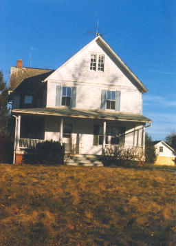
Mile 14.9 at Hunter Mill Road -- Lewis House, 10307 Saddleview Court. c. 1750. Built

|
|
| Lewis House, Mile 14.9 |
Mile 15.05 at intersecting horse trail -- farm house on the south side of the trail. c. 1879-1915 At first glance the aluminum siding makes it look modern, but this frame house stands alone on a farm, and its chimney and layout suggest it is old. visible from trail, backs to trail
Reston, a former town in Fairfax County
Mile 17.9 at Old Reston Avenue -- Wiehle mansion. 1902. Dr. Wiehle built this mansion. The Prison Fellowship owns it today. A figure in the Watergate scandal, Chuck Colson, founded the Prison Fellowship. One-half block off trailMile 17.9 at Old Reston Avenue -- Town Hall, Old Reston Avenue. c. 1892. Dr. Wiehle built this stone two-story structure as part of his Utopian community. It had a brick steeple. The preferred church of Dr. Wiehle, the German Reformed Church, met in its upper floor. When a distillery purchased the property, it used this building as a whiskey warehouse, and it removed the steeple. One-half block off trail; ascend Old Reston Ave.; visible from trail.
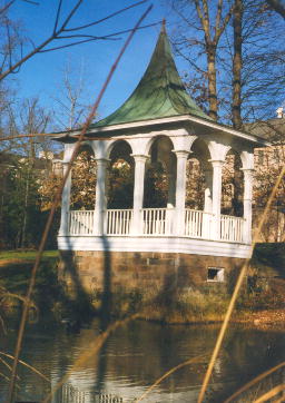
Mile 18.0 at Sunset Hills station -- gazebo c. 1900. Dr. Wiehle had this gazebo built on top of the foundation of a spring house. It overlooks a pond which was dug by hand. During the winter, ice was cut from this and neighboring ponds for storage in an ice-house. visible from trail.
Town of Herndon in Fairfax County
A walking tour of Herndon. Under constructionMile 20.0 at Monroe Street -- Kitty's Kitchen, 681 Monroe Street. c. 1860. Small white house, much altered. Backs to trail; visible from trail. See my page on the Civil War for more information on this house.
Mile 20.05 between Monroe St. and Elden Street -- The Darlington Housec. 1889. Green large Victorian with turrets Visible from trail behind some trees, south side of trail.
Mile 20.1 at Elden Street -- The Yellow House, 719 Elden Street. c. 1880-1890. Gabled, vernacular house with large porch. After a fire in 1927, served as temporary library and school. Once occupied the place of the next-door funeral home. Off a gravel drive extending back along trail; visible from trail.
Mile 20.1 at Elden Street -- Berkely Green House, 725 Elden Street. 1890. Folk Victorian, white. visible from trail.
Mile 20.1 at Elden Street -- 700 Lynn Street (corner of Elden Street). c. 1850 - 1870. Red-roofed house with German siding, vacant, in disrepair. DEMOLISHED, JULY, 1999 visible from trail.
Mile 20.2 at Train station -- Nachman Building, 718 Lynn Street. 1919. visible from trail.
Mile 20.2 at Train station -- office building, 773 Station Street. c. 1880-1900. visible from trail.
Mile 20.2 at Train station -- Old Safeway Store, 781 Station Street. c. 1920. Now Sylvania's restaurant visible from trail.
Mile 20.2 at Train station -- Community Bank, 783 Station Street. 1910. visible from trail.
Mile 20.2 at Train station -- Zeffirelli's, 728 Pine Street. c. 1900-1920. Was the five and dime store. visible from trail.
Mile 20.2 at Station Street -- Herndon Clock and Watch, 715 Pine Street. c. 1900. Heavily altered Victorian. along commercial row on Station St., right on Pine
Mile 20.2 at Station Street -- Detweiler House, 711 Pine Street. c. 1890-1915. Dr. Detweiler was shot dead here by the son of a patient who disliked the doctor's advice. along commercial row on Station St., right on Pine
Mile 20.2 at Station Street, Edna Bicksler house -- 600 block, Spring Street. Lewiston model, circa 1927.
|

|
|
| Four Square American house. |
Mile 20.2 at Station Street -- 1000 block, Grant Street. A Sears house, Maytown model.
|
|
| Maytown Model, from the Sears catalog. |
Mile 20.2 at Station Street -- Herndon Fortnightly Library, 1927. 660 Spring St. Built by an organization of women who wanted a library. Now the Herndon Friends Meeting. at Station Street, curve and descend across Elden, becomes Spring St. Two blocks off trail.
Mile 20.2 at Station Street -- 660 Spring St., Methodist Parsonage 1908 652 Spring Street. Vernacular Victorian in good shape. at Station Street, curve and descend across Elden, becomes Spring St. Three blocks off trail.
Mile 20.3 at caboose -- Methodist Church, Center and Elden Streets. 1872. Gothic revival style with gothic windows. Now the Church of Jesus Christ. Standing at caboose, look for a white frame church away from Town office complex. Visible from trail three blocks away.
Mile 20.3 at caboose -- gas generating station. Next to the Herndon library, this small concrete structure has an interpretive sign.
Mile 20.45 at Grace Street -- 764 Grace Street. c. 1890 Red roofed house, altered by aluminum siding. Grace Street has no sign, but it is the first intersection west of both the caboose and bridge. Visible from trail.
Mile 20.45 at Grace Street -- Castleman School Building, 763 Grace Street. c. 1890 - 1915. Grey Victorian. Grace Street has no sign, but it is the first intersection west of both the caboose and bridge.
Mile 20.45 at Grace Street -- 756 Grace Street. c. 1890 - 1915. Vernacular Victorian, with barn in back. Ascend Grace Street. It has no sign, but it is the first intersection west of both the caboose and bridge.
Mile 20.45 at Grace Street -- 814 Elden Street, corner of Grace St. c. 1870. Original shutters, siding and fishtale shingles.
This page last updated Feb 9 2006 by