- Petaled 'Crater' -
in Mars Terra Sirenum
Analysis of Mars Odyssey (THEMIS) data release image number: V01354003. All source images used are
courtesy of NASA/JPL/Arizona State University(ASU).
Following the THEMIS data release for V01354003, this investigator will
attempt to show that the petaled 'crater' at (483, 2964) in the Apparent
Brightness Record (ABR) image is a feature that is not meteoric in origin,
but is instead a geyser or similar feature of tectonic nature.
Table of Contents:
- Image Sources.
- GIMP Cubic Spline Interpolation Verification for Feature Scaling.
- The 'Petaled Crater'.
- Shape from Shading (Photoclinometry).
(NEW).
- Comparison to Splatter Crater.
- Comparison to Other Features.
- Adjacent Mars Orbiter Camera(MOC) Images.
- Apparently Square Crater and 'Underground Structures.
- Conclusion.
Image Sources:
First seen as Daily Release 20021002 on the
ASU/Themis website
for October 2, 2002. This is a visual image only, at a resolution of approximately 18 meters/pixel, with
no corresponding MOC image (see Adjacent
Mars Orbiter Camera(MOC) Images, below). The size of the feature
of interest is relatively small, with a linear span of approximately 30 pixels,
or 570 m (1870 ft). The approximate area of the petaled 'crater' feature
is 810 pixels, or 262,000 m² (861,000 ft²).
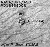 Figure 1.
  Figure 2.
Figure 1 is an un-retouched crop
of the feature at (483, 2964) in V01354003ABR.IMG
(3.76MB), and surrounding area, using GIMP
coordinates, after conversion via NASAView to GIF format. The top left corner of the
image as displayed in GIMP is coordinate (0,0). Figure 2 is taken from V01354003EDR.QUB (3.76MB)
also converted with NASAView to a GIF format file, then further processed
with the GIMP Image --> Colors --> Adaptive Contrast tool, using a
value of 25 for the iterations, and a value of 35 for the detail size.
GIMP Cubic Spline Interpolation Verification
for Feature Scaling:
Due to the reduced size of the image, a short movie showing the scaling
process is included to verify that the GIMP cubic spline scaling algorithm
is not introducing significant distortion into the image. Due
to the large size of the movie, it will not be included in the page.
See 1x to 10x Verification Movie (1438KB).
The methodology here is to start of with an original pixel size image, which
is 52 x 80 pixels, and progressively increase the scaling factor so that a
10x scaling occurs, in sequential increments. The 1x scaling has a
1 second delay, and the 10x scaling has a 2 second delay, otherwise the delays
are 0.5 seconds between frames. As can be seen from the GIF movie, feature
rendition is accurate during scaling. Generation of the GIF movie was
accomplished via Adobe Photoshop 7.0, rather
than with GIMP itself. This results from the failure of Unisys
to release their patent on LZW technology to GIMP users doing research. This
author did attempt to get a single site license for the GIMP GIF plug-in,
but was rebuffed by Unisys.
The 'Petaled Crater':
The parameters for the Sun Azimuth, North Azimuth, and Incidence Angle
where taken from the IMG label as generated by NASAView. The values
are SUB_SOLAR_AZIMUTH = 208.964°, NORTH_AZIMUTH = 266.308°, and
INCIDENCE_ANGLE = 57.758°. Figure 3,
following, is a 10x scaling done with GIMP using cubic spline interpolation.
It must be remembered that this is a relatively extreme scaling (10x), and
therefore all noted features are at the extreme of resolution. There is no
guarantee that the scaling has not introduced spurious details in the features.
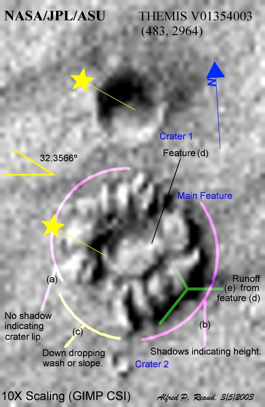 Figure 3.
Starting with the left side of the petaled 'crater', we proceed alphabetically
down the list of feature elements:
- The west most side of the crater should
be in shadow, but is not, as shown by comparison with Crater 1 to
the north of the main feature. It is possible that if our main feature
is a putative crater, then the inner wall slopes at less than a 32.242°
angle from the horizontal. However, this investigator does not believe
so due to the signature of other details on that side of the 'crater', specifically
the bright areas at the west through northerly directions (as indicated by
the highlighting at (a)). Shadows of up to 5 pixels in horizontal extent
do indicate that on this side of the 'crater' there is a partial depression,
or that the 'crater' lips rise above the central area by up to 54 m (176
ft). Crater wall collapse presents certain shadowing dilemmas which
are contrary to a crater depression presumption.
- The southeast side of the 'crater' wall shows indications of shadows
on the outer rim. However, this area should be in light on the inside areas
of the wall, as can be also seen via comparison to Crater 1.
This is opposite to what would occur if the feature were a 'crater'.
The possibility exists that this 'crater' has a raised lip, however, the raised
lip must have a sharp outer edge, and this edge is not visible on the western
side in (a). This is visual ambiguity here, however, as the 'crater'
appears to have lighted areas on the walls in a 360° sense. Regardless,
photoclinometry shows that the feature here has shadow lengths of from four
to six pixels, 43 m (141 ft) to 64 m (211 ft) high, with one section having
a feature that has a shadow length that is eight pixels long, 86 m (281 ft)
high.
- The southwest side of the 'crater' appears to have a downward going
wash or slope feature that goes to the southwest. The direction assumption
results from the normal widening of talus or debris fields going from an
upper source to a lower termination. The widening gradient goes from
inside to the outside of the 'crater'. There also appears to be an
outer circumference ring of material at this point, which indicates where
the flat surface of the area outside of the main feature begins. Details
in this area indicate heights of up 21 m (70 ft), but averaging 11 m (35
ft) or less.
- Feature (d) appears to be a raised projection in the 'crater' central
area. The projecting discoloration (discussed in e.) that appears to
focus on this feature is not a shadow, as it does not follow the projection
of the sub-solar azimuth. There is no significant shadow associated
with this image, making its height less than 11 m (35 ft).
- The discolorations, which focus on the feature (d), appear to flow
away from the feature and continue to the southeast. There is an appearance
of flow at the inner concentric ring, which would be the floor of the 'crater',
to the south of feature (d). The flow branches off into two separate
'runnels' which proceed in semi-radial fashion towards the outer circumference
of the 'crater'.
Shape from Shading (Photoclinometry):
The author has developed a shape from shading plug-in
for the GIMP 1.2.4 imaging application. Using the shapefs plugin, the following
3D images where generated. The source for the 3D renderings is Figure 3,
above.
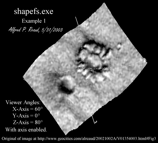 Figure 3A.
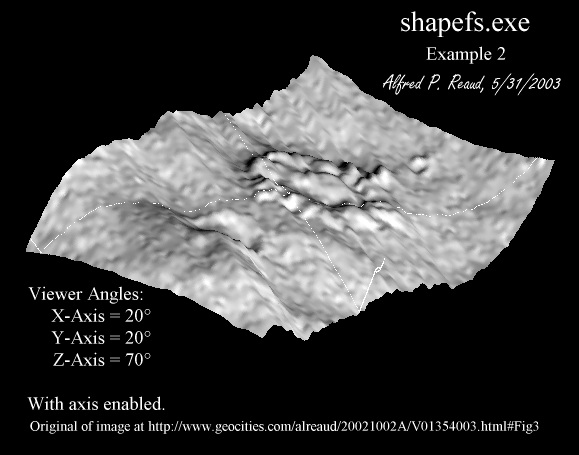 Figure 3B.
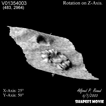 Figure 3C (974KB).
As can be seen for the above three images (Figures 3A, 3B, and 3C), all three show height succinctly.
These 3D renderings support the arguments stated in the previous section
with respect to a feature that actually rises above the surface, as opposed to the Crater 1 in
Figure 3. Figure 3C,
just prev, links to a GIF movie (974KB) of the above feature, rotating 360° on
the Z-Axis, with X-Axis angle = 25°, and Y-Axis angle = 50°.
Comparison to Splatter Crater:
For comparison, a splatter crater was located at (564, 2140) in V01354003ABR.IMG
(3.76MB) at a distance of 827 pixels, 14.9 km (9.3 mi) to the north-northeast
(5.69°) of the main feature. Figure 4
has been processed from the original using the GIMP Image --> Colors
--> Levels function to spread out the histogram and to lighten up the
overall image. Figure 5 is a 4x GIMP cubic
spline interpolation of the feature in Figure 4.
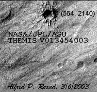 Figure 4.
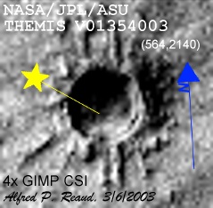 Figure 5.
Figure 5 shows a crater with a surrounding splatter
signature. As opposed to the main feature, Figure
1 and Figure 3, this crater example,
though unusual, shows the classic signatures of a crater. These signatures
include shadowing on the same side as the sun location, lighted sides on
the side opposite the sun location, a semicircular inner crater shadow, and
lack of significant shadowing on the rim side farthest away from the sun
location. Photoclinometry shows that this is a relatively deep crater,
with a rim wall to floor depth of 142 m (467 ft). The crater wall gives
a wall shadow of approximately 1 to 2 pixels, or a height of less than approximately
21 m (70 ft). The splatters are approximately 261 m (856 ft) long with
a standard sample deviation of 190 m (623 ft) and appear to leave the crater
in a radial fashion. The splatter heights are approximately the same
as the crater wall height. There is evidence of collapsing of the east
through southeast crater wall. This feature is visible on I01354002
at GIMP coordinates (178, 1117) on I01354002BTR.IMG.
Comparison to Other Features:
The other comparison feature is at (677, 2753) in V01354003ABR.IMG
(3.76MB) at a distance of 288 pixels, 5.18 km (3.22 mi) to the northeast
(42.6°) of the main feature. Figure 6
has not been processed from the original other than conversion to GIF format
from PDS IMQ format via NASAView. Figure 7
is a 4x GIMP cubic spline interpolation of the feature in Figure 6.
 Figure 6.
 Figure 7.
As can be seen, the shadow in this crater is relatively small in horizontal
extent, indicating a shallower crater. The shadow extent indicates
a wall height of from 2 pixels to 7 pixels, 21 m (70 ft) to 75 m (246 ft).
It is apparent from close observation of the area under the sun azimuth
indicator in Figure 7 that the area appears to
have slumped down from the west crater wall in a southeasterly direction.
Crater wall heights appear to be 1 to 2 pixels, or 11 m (35 ft) to 21 m (70
ft). Floor texturing is very similar to the surrounding area, possibly
indicating an older crater that has probably been inundated with blowing
debris. This feature is visible on I01354002
at GIMP coordinates (198, 1213) on I01354002BTR.IMG.
Adjacent Mars Orbiter Camera(MOC) and THEMIS
Images
MOC images that appear to be in the same general crater are at the following
locations. The center image coordinates for the feature discussed
herein is 44.541°S, 151.122°W, using MOC coordinates. This
is as of the latest MOC Narrow Angle Gallery release (March 11,
2003).
Apparently Square Crater and 'Underground Structures:
Crater 2 in Figure
3 shows a crater that is plainly square. This is an example
of where even as robust a scaling algorithm as GIMP's cubic spline interpolation
fails where the original data is insufficient to allow for the required
magnification. Figures
1 and 2
show the unmagnified size of Crater 2. This feature is approximately
25 pixels in area (5 x 5), and will not magnify correctly regardless of
the scaling algorithm used. Figure 8
shows four examples of the different scaling algorithms in GIMP. GIMP
Zoom appears to be the same as GIMP Nearest Neighbor scaling. Figure 9 gives similar examples for Adobe Photoshop
7.0. Photoshop Zoom also appears to be the same as Photoshop Nearest
Neighbor scaling. The results of the scaling is very similar between
GIMP and Photoshop, with slight textural differences between the two in cubic
and linear modes.
 Figure 8.
  Figure 9.
Similar effects result in the rectangular patterns visible in Figure 3
surrounding the main feature. These rectangular patterns are NOT
underground, surface, or artificial structures of any kind. These are
plainly features caused by processing of the image via a scaling algorithm.
In an attempt to perform beyond the resolution of the image itself, the scaling
algorithms fill in with what would be mathematically correct for a certain
pixel curve. Mathematical correctness, however, does not imply physicality,
and many independent investigators have fallen into this trap with Mars imagery.
Conclusion:
The petaled 'crater' in Mars Terra Sirenum shows evidence that it may actually
not be a meteor crater. Feature comparison with surrounding craters
indicates that this 'crater' is strikingly different from any others in
the area. Shadow signatures do not match that of conic
al section craters,
being on the wrong side of the feature. One sector of the rim of the 'crater'
shows a wash or slope that is consistent with a fall from the center outwards,
instead of a fall from the rim inwards. There are similarities with
a nearby splatter crater, but there are significant differences between the
two.
Due to the shadow signature of the petaled 'crater', its internal features,
and it's rim structure, this 'crater' appears to be a raised feature instead
of a depressed feature as a crater normally is. In the opinion of this investigator,
morphological discrepancies with classic craters indicate similarities to
certain features seen in the southern hemisphere of Mars, which appear to
be fluid geysers, giving a concentric outer raised ring, and an interior
plateau with a central orifice. Future revisions of this page will attempt
to relocate the MOC image numbers for those other features so that morphological
comparison may occur
These presumptive conclusions are refutable with MOC imagery of the 1.5 m caliber.
Back To Home Page
© 2003-2004
Alfred P. Reaud
Independent Investigator
Created: Friday, February 28, 2003
Current:
Monday, October 03, 2005

 Figure 3C (974KB).