
First Day
8:00 a.m. Sitkum Hall. I remove rock hammers and videos from the geology lab with Louis Rushton and Brad Laird and place them underneath the bus. We had an on-bus discussion of sleeping arrangements and signature of hold harmless forms. Depart Southwestern at 8:15.
9:40. Stop 1/i-1. Off the side of the road on Highway 38. Just past the Sutherlin turnoff, at some layered cliffs.
These cliffs are composed of a dark sedimentary rock that crumbles easily. Highway 38 itself cuts through these layers of rock, exposing them to view. The layers, as far as I can see, seem to be continuous across the road, i.e. were continuous before the road cut through them. There is a variation in thickness between the layers composing the stone: They are thick on top, exhibit a thick-thin variation in the middle, and are thick again on the bottom. The top layer of the ridge is the thickest visible layer. According to a consensus of students more knowledgeable than I about geology who sits near me on the bus, the thin layers are composed of mudstone and the thicker layers are composed of sandstone. The Roadside Geology of Oregon explains that these sedimentary rocks are about 50 million years old. (103)
 The layers of rock are tilted upwards on the eastern side of the formation. The angle of their intersection with the ground varies from approximately 15 to 30 degrees, depending upon the point at which the layer intersections the ground. Larger angles are more common than smaller angles. The estimated height of the rock formation is 82 feet. There is a great deal of talus, or broken fragments of the cliff-rock, at the cliff's base, as this cliff is made of fairly soft rock.
The trip handout informs us that this is a micaceous part of the Tyee sandstone formation.
Depart 9:40.
10:05. On bus, en route to Goshen. I notice fenced-in llamas on the right (south) side of the road. Elk Creek is swollen, and its waters look very green.
10:15. On bus, en route to Goshen. We pass visible, exposed layers of rock cut through by the road, in the same way that we saw rock layers exposed on stop 1/i-1. These rock layers appear to lie very close to true vertical (that is, they approximate the direction of a plane intersecting the center of the Earth and which is perpendicular to a plane tangent to the surface of the Earth). They are oriented not at all like the nearly horizontal, gently upward-sloping layers of stop 1/i-1.
10:17. On bus, en route to Goshen. The bus travels over the junction from Highway 38 East to Interstate 5 North. We pass some more exposed rock layers at this intersection. These sedimentary layers are again oriented in an off-horizontal direction, but slope downward to the east. I notice that the rocks off to the right of the bus as we pass over the junction are different: They are lighter and more erosion-resistant, and look like sandstone.
The trip handout informs us that this visible outcropping is also part of the Tyee sandstone formation, similar to the outcropping visible at Golden and Silver Falls. The trip handout has already contrasted the outcropping at Golden and Silver Falls with the outcropping at stop 1/i-1. Assumedly, then, this outcropping is not micaceous, as the outcropping at stop 1/i-1 was.
The bus drives on.
10:30. Stop 2. Rest stop just south of milepost 179 on Interstate 5. This stop lasts ten minutes. Louis and I each donate a dollar for coffee; the money is supposed to go to a college scholarship fund for graduates of Willamette High School. Students use the bathrooms and mill around. We depart and drive northward at 10:40.
10:50. On bus, en route to Goshen, approximately at milepost 185. We pass the Short Mountain Landfill, which was mentioned in the Eugene Register-Guard four or five days ago. This landfill, like most landfills, generates methane gas at little to no additional charge beyond the cost of landfill construction, maintenance, and operation. Though this methane gas is somewhat impure, it can easily be captured and mixed with more refined methane gas to use as fuel. There is, thus, essentially no additional cost to produce this energy source.
However, according to the Register-Guard article of 17 February 2004, the plant is producing less methane than it was anticipated to produce when it opened twelve years ago, and the amount of methane that it produces is decreasing. This is due, in large part, to the fact that organic materials, which decompose to form methane, are increasingly being diverted to places other than the landfill — recycling and composting initiatives, for instance, and curbside yard-waste gathering programs. (Maben D1, D3)
10:55. Stop 3. Goshen, exit 188B. About four miles south of Eugene.
We pulled off the highway and parked, then climbed up the hillside to the east of the exit ramp, which consists of layered sandstone. These layers of sandstone are different colors and different thicknesses. Often the difference in color is striking, as in the piece of sandstone I collected from the site. This sample has striking black-and-white layers.
Students grabbed rock hammers when getting off the bus and contributed to erosion by digging in sandstone outcroppings for fossils, which can be easily found in this area. Several students found rocks impressed or discolored by parts of plants: leaves, petals, stems, etc. Brad accidentally smacked me in the knee with the flat end of a rock hammer. I limped back down the hill, remembering to take my layered sandstone and my fossil, a piece of sandstone with the nearly complete impression of a small leaf.
The photos below show a group of sheets of the sandstone that I peeled off with the pointed end of the geological hammer I used. This sandstone was particularly soft, and easily peeled off in sheets. The picture on the left shows the gap in the rock-shelf from which I extracted three sheets of sandstone; the picture on the right shows these three sheets of sandstone stacked. The process of removing these sheets took less than three minutes, which demonstrates how soft this sandstone is.


We are posed the question of whether these fossils were deposited under water. This seems likely. According to Orr and Orr,
[Delicate] leaves fossilize best only if they are pressed flat. This condition is typical of lake sediments with fine-grained clay size particles such as the muds and shales. [...] Leaves are most frequently preserved as carbon film in the entombing rock. This type of fossilization, called "distillation," is the simply process of removing all the volatile organic material from the leaf without disturbing the basic shape. (5-6)
The trip handout informs us that this stop shows us an outcropping of the Goshen Flora, which has been radiometrically dated at about 31 million years. Interestingly, this formation does not show the coastal influence that is shown by the floras in the Willamette Valley — which is very close to here.
Orr and Orr also say that the "Goshen flora of west central Oregon is typical of a low latitude, tropical to subtropical rain forest in an inland protected situation. The flora was deposited near sea level as is shown by association with marine molluscs." (24)
Depart 11:30.
11:35. On bus, en route to Skinner Butte. We pass over a road-cut that exposes a sandstone formation exhibiting vertical layers.
11:45. Stop 4/i-2. Skinner Butte. This stop serves as a substitute for the stop at Spencer Butte mentioned in the trip handout. (We did not visit Spencer Butte due to fog.)
Notable at Spencer Butte is a north-south running rock wall formed of columnar basalt. I estimate the height of the wall at 32 feet. When we arrived at the site, there was a climber in an orange jacket climbing the wall. By the time we departed, he had climbed into his California-license-plate-bearing, windowless car that had been spray-painted with anti-government slogans and driven away.
There are two plausible theories explaining the formation of these columns: It may have flowed across the surface, then been lifted to its present position by tectonic activity or other geological forces. It may also have flowed into then-extant rock, forming an intrusion more durable than the rock into which it intruded; the rock it flowed into would then have later eroded, leaving only the basalt columns visible today.
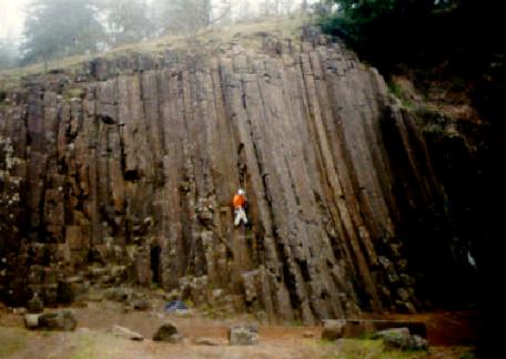
As this lava cooled, it shaped itself into roughly hexagonal patterns. The hexagon is a shape often found in nature because it is strong, stable, and space-efficient. These hexagons are being eroded, however, by weather and by the plants and lichens growing on them. I notice that the columns on the north side of the wall are more weathered and broken than those on the south end. The photos below show, first, the north end and, then, the south end of the columns at the butte.


Depart 12:00 for our lunch stop.
12:15 p.m. On bus, en route to Mt. Tabor. We pass a butte just south of mile 198. This butte is a hopeless mass of columnar basalt and sedimentary deposits in layers oriented in positions ranging from horizontal to vertical — a genuine geologic nightmare.
12:20. Stop 5. Oak Grove rest stop. Lunch stop, where I consume a peanut butter and jelly sandwich and some smoked salmon. I notice that the informational "park rules" sign describes a $500 fine for washing dishes in the sink at the rest stop.
Depart 12:45.
1:40. On bus, en route to Mt. Tabor. I wake up from my on-bus nap just long enough to notice that we are crossing north over the 45th parallel. Several minutes later, I go back to sleep.
2:35. Stop 6/i-3. Mt. Tabor in Portland.
A ruin like the Slides of Mark near Trent
On the bank of the Adige, the result of an earthquake
Or of some massive fault in the escarpment—
For, from the point on the peak where the mountain split
To the plain below, the rock is so badly shattered
A man at the top might make a rough stair of it.
-Dante Alighieri, Inferno xii.6-11
We walked off the bus and across the park's amphitheater to observe a layered wall of porous black scoria, tilted, on the other side; it is black, brown, and red-brown in places. There is a layering of pyroclastics exhibited here, which provides evidence of multiple eruptive events. The layering is only visible in certain spots on the wall, however, as many parts of the wall have been covered over by dirt and eroded. This is especially evident at the southern end, where a syncline contains red material, possibly soil, definitely something containing iron. On close observation, I also noticed that there are, in places, smaller chunks of rocks that had been trapped by the basalt flows and were now part of the rock wall; I could not determine what kind of rock they were, however. Overall, the rock composing the wall is basaltic in nature.
The layering mostly points in the same direction and provides evidence of a vent that must have been behind our position as we faced the rock. It must have then been uplifted. The angle at which these layers intersect the ground is, in places, slightly greater than 30 degrees, as below.

The trip handout informs us that this volcano formed about 1.2 million years ago during a period of Portland-area seismic activity that was most intense during the period of 3 to 1 million years ago. It also says that the lava flow in this area is about 200 feet thick.
We departed at 3:00 and passed a reservoir on the way out. Several people on the bus insisted that this reservoir has been seen as a potential target of attack by ecoterrorists. It is also apparently a source of political tension in the community, if the lawn-signs in the area are any indication.
Our on-bus lecture on the way out informs us that the many terraces in Portland are often used as bases on which to build houses. Unfortunately, these terraces are often formed by tectonic faults.
On-bus movie: Sling Blade.
3:30. On bus, en route to Astoria. Visible all at once are Mt. Saint Helens, Mt. Hood, and Mt. Adams.
3:50. On bus, en route to Astoria. About milepost 32. While traveling west on Highway 30 down the Columbia River toward the town of St. Helens, we pass a sign reading "St. Helens 6." Oddly enough, almost immediately, we pass another sign reading "St. Helens 7."
4:00. On bus, en route to Astoria. We pass out of the town of St. Helens. Now we can see both Mt. Ranier and Mt. Adams.
4:15. On bus, en route to Astoria. We pass a small nuclear power plant around milepost 45.
4:35. On bus, en route to Astoria. We pass a large landslide heading downhill into the town of Clatskanie. It is obvious that the slide is not particularly recent, as trees can be seen growing from its surface. As the Roadside Geology of Oregon puts it,
The Astoria mudstones are very weak rocks which weather rather easily to form deep soils which have approximately the consistency and mechanical strength of grease when they get thoroughly soaked. Landslides have been a problem along this part of the coast for years and will certainly get worse unless future development on the steeper slopes is planned to avoid making them any steeper or wetter than they already are. (82)
5:30. Stop 7. Lamplighter Inn in Astoria. We check in to our various rooms; I am in room 116.
6:15. In Astoria. Depart room 116 on foot looking for dinner. We wandered up and down Highway 30 until we found the Plaza Jalisco, a Mexican restaurant. Our group sat in the bar, waiting for a table and discussing tequila with the bartender, for twenty minutes, then waited a half-hour to order a bland burrito colorado. I departed the restaurant at 8:20 and headed back to the Lamplighter Inn to read Rousseau.
11:45. Lamplighter Inn. Bedtime.
Second Day
7:30 a.m. Lamplighter Inn. The occupants of room 116 (except for Brad, who is already showering) are awakened by a phone call from Venus, a geology student in room 112, who invites us down to drink lattes made by the espresso machine that she brought with her. The lattes were excellent.
8:05. Motel parking lot. The magic bus departs the Lamplighter Motel.
8:20. Stop 8/ii-2. The Astoria Column in Astor Park.
 As we leave the bus, we are cautioned not to throw anything from the top of it except for the balsa-wood planes sold by the gift booth (which was closed at the time).
  Throwing anything else from the top of the column could result in a $500 fine, as it is considered hazardous — judging by the amount of the fine, as dangerous as washing dishes at a rest stop. We climbed up to the top of the column, a climb of 164 steps up a circular staircase that runs counterclockwise; the landings along the stairway are not spaced evenly apart.
The outside of the column depicts the early history of Euro-American settlement of the area, from the discovery of the Columbia River by Captain Robert Gray in the ship Columbia to the coming of the railroad to the area. The column was built in 1926. It was designed by the New York architect Electus D. Litchfield, who patterned it after the Trajan Column, erected by the Roman Emperor Trajan in 114 A.D. It was decorated by the Italian-born artist Attilio Pusteria using a sgraffito technique. At the time of the Column's construction, it cost $27,133.96 to build and decorate. In 1995, it cost approximately $750,000 to restore the column. (Friends 1-2)

The top of the column provides an aerial view of the bridge leading from Astoria across the Columbia River to Washington (as shown in the photo above), of the flood plains to the south across Young's Bay (as the photo below shows), and of the Lewis and Clark river. We also have a good view of Saddle Mountain from the top of the column. Saddle Mountain was formed by Grande Ronde basalt flows about 15.6 million years old; in this area, these flows have since been uplifted into Saddle Mountain and other mountains visible from here. (Mueller and Mueller 250)

I estimate the height of the column at 45m, but the accepted value is 38m.
The view from the top of the column also provides an excellent view of the town of Astoria, which is situated on low hills that have eroded into soft mudstones deposited about 20 million years ago. At that time, this part of the Coast Range still lay under the surface of the ocean. (81)
Depart 8:40 a.m.
8:52. On bus, en route to Cape Disappointment. The bus begins to cross the Astoria Megler Bridge at a speed of — according to Jerry the bus driver — a constant 55 m.p.h.
8:53. On bus, en route to Cape Disappointment. We pass a sand bar in the Columbia River. The water in the river is dirty, because it contains a large amount of sediment washed into it from upstream.
8:56. On bus, en route to Cape Disappointment. We leave the bridge and head north (according to the highway system) or west-northwest (according to a map) on Highway 101 in Washington.
9:20. Stop 9/ii-1. Cape Disappointment in Fort Canby State Park.
—Therefore, unwilling to forget that day,
My Friend, Myself, and She who then received
The same admonishment, have called the place
By a memorial name, uncouth indeed
As e'er by mariner was giv'n to Bay
Or Foreland on a new-discovered coast,
And, Point Rash-Judgment is the Name it bears.
-William Wordsworth, 'A narrow girdle of rough stones and crags' (part of the "Poems on the Naming of Places" sequence)
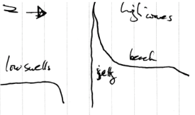
We hike from the bus uphill to the lighthouse. It provides a view of the Pacific Ocean. This view is bisected by a jetty running westward from the land into the ocean, as in the photo below. This jetty is composed of rock that, we are told, we will see the next day, ten to fifteen miles south, at Neahakanie Mountain Viewpoint (stop 23/iii-2). The jetty serves as a visual marker of a striking difference in the way waves behave on either side of it. On our side, the south side, the waves are fairly rough, considering the relative calm of the wind; on the north side of the jetty, they are extremely rough.

Cape Disappointment derives its name from the experience that Lewis and Clark had here. They had traveled westward searching for a water route through the country, and had hoped to find it in the Columbia River. They were disappointed to find that the bar at the mouth of the Columbia is one of the nastiest and least easily navigable bars in the world.

Cliffs in the area are composed of a mixture of sandstone and basalt. The town four miles to the north of the jetty is named "Long Beach," which indicates the nature of the surrounding landscape. This "long beach" is actually a part of the delta deposited by the Columbia. It seems fairly safe to assume that these deltaic deposits continue to spread out underwater for a long way (the Columbia has quite a wide mouth) and that it may influence wave behavior and formation in this area, perhaps explaining why the waves are so rough. Roadside Geology of Washington explains that this 20-mile-long "long beach" is actually a baymouth bar that nearly cuts Willapa Bay off from the ocean. The sand composing this bar is sand deposited by the Columbia River and pushed northward by winter storms. (245-6)
Several students claim that they saw two bald eagles on the hike back down to the bus. I was not able to observe them, however.
Depart 9:55. On-bus movie: Earth Revealed.
10:20. Stop 10. Immediately before driving south over the Astoria-Megler Bridge. A two-minute stop before heading back over the bridge to collect a sample of rock at the entrance to the bridge. This rock sample is composed of basalt with small, shiny specks, possibly quartz.
10:35. Stop 11. Fred Meyer, Warrenton. Students purchase food and other items. Depart 11:15.
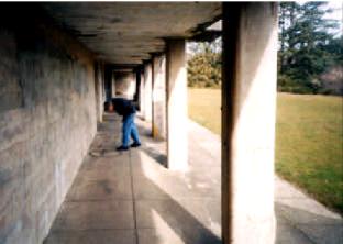
11:35. Stop 12/ii-3. Fort Stevens on the Clatsop Plains. The informational signs that we saw at this memorial emphasize its role as a World War II-era fort used to watch the Pacific Ocean. However, it was originally built during the Civil War; it was intended to protect against a British invasion from Canada, should the British have chosen to join the Confederates. It was completed in 1865 and was originally surrounded by a moat with a drawbridge. (Friends of Old Fort Stevens)
The fort is now open to the public but no longer maintained at military standards of cleanliness and has fallen into a state of some disrepair.

It was necessary to use spotters located away from the fort, as the forest between the fort and the sea prevents those located in the fort from seeing the ocean.
 According to informational signs on the site, Fort Stevens is the only military installation in the continental United States to have received enemy fire since the War of 1812. Beginning at 11 p.m. on June 12, 1942, the Japanese submarine I-25 fired seventeen rounds (according to the Friends of Old Fort Stevens, these were 51/2" shells) at the fort. All of the fort's batteries were ordered not to return fire, and the submarine, having failed to provoke a conflict, departed for the Aleutian Islands.
By 1947, the fort had been closed because of the end of World War II and because of the development of newer military technologies (such as guided missiles and the development of improved air power), which rendered Fort Stevens relatively obsolete. At its height, however, Fort Stevens housed more than 2500 men and women.
Depart 11:55.
12:00 p.m. Stop 13/ii-3. The beach at Fort Stevens.
We arrive for lunch at the site of the 1906 wreck of the Peter Iredale, which consists mostly of a iron skeleton that is completely isolated at low tide and can be reached, by carefully timed runs, even this close to high tide.
 The Peter Iredale was a four-masted barque built in 1890 in Maryport, England; its registered weight was 1994 tons. (Sandström 1) According to the British Naval Court proceeding of 13 November 1906, which investigated the 25 October 1906 stranding of the Peter Iredale, the ship was grounded due to fog and the strong currents near shore. The proceeding also found that the captain and crew were "in no wise to blame for the stranding of the said vessel." (qtd. in "Peter Iredale" 1)
The sand here is very fine and consists of basalt and heavy metals, some quartz, and some tan grains that may be feldspar. The trip handout tells us that the sand here is rich in particles of the magnetic iron-titanium ore ilmenite, or FeTiO3, according to Webster's Universal College Dictionary. (407)
There is a dune about four feet high right at the high tide line. The formation of this dune was initially puzzling until it was explained to me that the height of this dune might represent the height of the beach in summer. The dune formation would then best be explained by the fact that sand generally washes out to sea in the winter and is returned to the beach when prevailing wind patterns and other climatic variables change. The beach geography at our lunch stop thus provides an application of the principles demonstrated in the Earth Revealed video that we had seen on the bus earlier.

Two geology students inadvertently demonstrated the importance of beach safety by finding themselves caught in a (luckily mild) sneaker wave, which partially drenched them. We also saw three children playing on an unsafe, unstable weathered tree stump washing back and forth in the surf. They are pictured below. One of the children lost her glasses in the waves. Several of the less restrained people in our group of geologists suggested that this demonstrated the importance of natural selection.
 Because of the demonstration of the biological principle of natural selection and of the application of principles from the earlier video, someone suggested that this should be referred to as the "theory into practice" stop.
Depart 1:00.
1:10. Stop 14/ii-3. Astoria Country Club.
The bus drives down in between rows of fairways, then stops for a brief lecture before turning around and leaving. The course is composed of a long series of parallel fairways that are valleys lying between rows of stabilized dunes. Viewed from the side, the tops of the dunes exhibit a fairly regular sinusoidal shape. The shape of these long dunes implies that the course itself corrects for poor shots to a certain degree.

There are two prevalent theories about the manner in which these dunes formed. The more traditional theory suggests that these grassy hills are beach dunes lying transverse the direction of prevailing winds. The more recent theory suggests that these dunes are composed of deposits brought onto shore by Cascadia Subduction Zone events.
1:50. Stop 15/ii-4. Ecola State Park.
But oh! That deep romantic chasm which slanted
Down the green hill athwart a cedarn cover!
A savage place! As holy and enchanted
As e'er beneath a waning moon was haunted
By woman wailing for her demon-lover!
And from this chasm, with ceaseless turmoil seething
As if this earth in fast thick pants were breathing,
A mighty fountain momently was forced.
-Samuel Taylor Coleridge, "Kubla Khan"
We observe features of erosion and stabilization. According to the trip handout, this parking lot is placed on an active landslide area. This area has landslide problems because it is built on the shale layers of the Astoria formation. This stop highlights the intersection of igneous basalt flows (such as can be seen at Tillamook Rock) into the sedimentary Astoria formation (which underlies the cliffs here).
After getting off the bus, we walk along a fenced wooden walkway to overlook, passing a sign which reads:
SEA LION ROCKS
A SEGMENT OF THE
NATIONAL WILDLIFE
REFUGE SYSTEM
THOUSANDS OF SEABIRDS LIVE
AND NEST ON THESE PROTECTED
OFFSHORE ISLANDS AND ROCKS
 We observe Haystack Rock from a distance (pictured to the left) — we will visit it up close in several hours (on stop 17/ii-5). We also see the lighthouse on Tillamook Rock, which used to be connected to the mainland by an igneous intrusion. We are posed the question: Why would the material connecting it to the land have been eroded? After considering the question for the rest of the day, I hypothesized that the rock connecting Tillamook Rock with the mainland was most likely lower in height and/or elevation than Tillamook Rock and the finger of basalt on the mainland pointing to it (pictured below). This would explain why this middle section had been eroded below sea-level (and perhaps lower; we were unable to observe the ocean at that point) before the two still-visible features mentioned above: It would have been more exposed to the water than the higher-elevation features.
 Still, this answer begs an answer to the question of why the middle, connecting section would have been lower in elevation and/or height. There are several possible explanations. The mostly likely one seems (to me) to be that the thickness of the lava was originally more or less even, but that the formation was later disturbed by tectonic activity or deformed by pressure from other formations in the area.
All of this is pure speculation on my part, of course.
The wooden structure pictured above, which is the location where we first met when leaving the bus, looked at first glance like an attempt to shore up ground that was eroding. It turns out that it is a remainder of an old trail that eroded in a slide of 1996 or 1997.
 The entire area, from the high terrace above us (pictured at the left) to the area surrounding the lot the bus is parked in down to the slopes leading down to the beach, is formed by an old slide that occurred around 1500 years before present. This whole section of the coast is an active slide area, due to the steepness of the local slopes and the action of the ocean undercutting the faces of the cliffs. The Roadside Geology of Oregon and Mueller and Mueller say that the present parking lot replaces another in roughly the same location that was swept off by a slide in 1961. (Roadside Geology of Oregon 84; Mueller and Mueller 256) This slide, as well as other slides that occur in the area, was caused by shallow faults in the sandstone that overlays the surface basalt in the area. (Mueller and Mueller 256)
The Tillamook Rock lighthouse has an interesting history. Mueller and Mueller have this to say about it:
Tillamook Rock was once a lighthouse site — a precarious one at best; on several occasions the glass of the beacon has been broken by boulders hurled by winter storms. One 135-pounder was lofted more the 90 feet high and landed in the keeper's house. The lighthouse has been abandoned and is now a privately owned columbarium. (254)
Depart 2:30.
2:35. Stop 16/ii-4. Indian Beach at Ecola State Park.
 We hike down to a beach covered by rounded stones, which are primarily basalt. It seems that this beach should provide good skipping rocks, but most of the rocks here are too thick or uneven to skip well. Nevertheless, I managed to skip several across the largest diagonal width of the small pond.
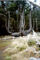
We see an eroded hillside (diagrammed below and pictured to the right) that exposes several layers of the interior of the local land. On top is a comparatively thin layer of soil that includes samples of shell midden. According to Mueller and Mueller, this is the site of a prehistoric tribal village. (256) Underneath is a larger layer of rocks, comparable to the rounded basalt pieces on the beach but with sharper corners, embedded in a reddish sand or silt. Beneath this is a layer of clay slightly thicker than the basalt-and-silt layer above it. An embedded tree root bisects this last layer. A nearby sign says that these trees were buried about 1700. This date suggests that they may have been buried by the often-discussed Cascadia Subduction Zone event of January 1700.
Depart 3:15.
3:40. Stop 17/ii-5. Cannon Beach.
We hike out to the beach and hike southward to Haystack Rock. One group member attempts to cross a narrow channel to Haystack Rock when the waves have temporarily retreated, but turns back after being soaked above the waist and cutting his foot.

Haystack Rock is a 235-foot-tall basalt monolith, middle Miocene in age, not connected to the mainland. There are several smaller monoliths surrounding Haystack Rock, called "the Needles." (Mueller and Mueller 256) These rocks are remains of small volcano-type formations that occurred when lava erupted to the surface. These formations differ from other volcanoes in that the lava that erupted from them originated from underground lava flows that had themselves erupted from the earth's surface far to the east, near the Idaho border, and then flowed underground on their way to the Pacific. These lava flows erupted from fractures in coastal sedimentary rocks and formed the rocks that we now observe, which display the "pillow" shapes and the shattered structure that typify the rapid cooling of basaltic lava on contact with water. (257-8)
Haystack Rock has given its name to the tasty Haystack Black porter beer, manufactured by MacTarnahan's Brewing in Portland. This beer won silver medals in 1996 from both the Association of Brewers' World Beer Cup and the World Beer Championships. (MacTarnahan's 2)

The sand level slopes very gently downward to the west here. The sand itself is grainier than the sand near the Peter Iredale wreck.
Depart 4:40.
5:15. Stop 18. Lamplighter Inn. I spend the evening taking a shower, writing in my journal, reading Rousseau, eating McDonald's, and watching Saturday Night Live and Bowling for Columbine. I walked out on an (unsuccessful) stamp hunt late at night.
2:00 a.m. Lamplighter Inn. Bedtime.
Third Day
7:00 a.m. Lamplighter Inn. The tenants of room 116 receive a telephone call from Venus. Lattes are ready.
7:30. Motel Parking Lot. The magic bus departs the hotel parking lot. Goodbye, room 116.
7:40. Stop 19. Fred Meyer in Warrenton. The price of a venti house coffee is $1.60. Depart 8:05.
8:15. On bus, en route to Hug Point. The bus passes a church on Highway 101 whose pithy sign reads, "We are human beings, not human doings. Rest rest rest."
8:20. Stop 20. Gas station near Seaside. The bus needs refueling. Everyone steps off, and Jerry pumps in 78 gallons. Depart 8:30.
8:50. Stop 21/ii-7. Hug Point.
The click of spades-ah, how it heartens me!
It is my crowd that toils the while,
Earth with itself to reconcile,
To set fixed limits to the sea
And gird it with a rigid zone.
-Goethe, Faust Part II, lines 11539-11543 (tr. George Madison Priest)
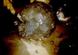
We walk down to the beach and sprint around to the north side of the Point to see caves and a waterfall (pictured below). There was a disagreement between the president of the Geology Club and our esteemed professor about whether the caves we visited were or were not depicted in the movie The Goonies. The waterfall falls over Miocene sandstone.

This sandstone shows oddly regular cubic patterns in places where it is possible to see the layers in cross-section, as shown in the photo below of water trickling down the side of this sandstone formation:

The beach at this stop shows thin bands of black sand containing heavy metals; these heavier grains of sand are collected together because the wind and waves sort them by weight. The picture below shows a band in the beach sand at this location.

We sprint back to the south side of the Point, and most of us are caught midway on top of rocks that we dashed onto to stay dry, as depicted in the photo below. We see igneous intrusions on the beach, which are also mid-Miocene in age. The sand here is wet and fine. There is a well-defined line, running roughly parallel to the water's edge, that marks off two sections of the beach. On one side of the line — the eastern side, further away from the water — the beach is covered several layers thick with rounded stones of several types (primarily basalt) cast up out of the ocean. On the other side, closest to the water, there are very few stones, and the underlying sand is the predominant feature of the surface of the land.

At this time, there was another incident of a student wet by the waves when we ran back around the point. His pants cuffs were soaked.

This point is called "Hug Point" because pioneers in the area used the beach as a convenient wagon "road" when settling the area. Area locals attempted to improve the beach's utility as a road by blasting away part of one of the headlands so that the tides in the area did not restrict the flow of wagon traffic. Still, the road was only usable at low tide, and the wagon traffic had to "hug" the point closely to get past — hence the name. (Mueller and Mueller 258)
According to our esteemed professor, the old section of Highway 101 used to hug this point closely. Apparently, it is visible (or its remains are) from the top of the waterfall falling over the Miocene sandstone, although I did not observe it.
The Roadside Geology of Oregon explains Hug Point's existence and formation in this way:
Hug Point [...] [exists] because large intrusions of basalt in the mudstone buttress parts of the coast against wave attack. These intrusions formed where masses of molten basalt magma squirted into the mudstones and cooled within them instead of erupting as lava flows on the seafloor. [...] Observation of the contact of the intrusions shows that the molten basalt squirted into soft, sloppy mud — not solid mudstone. (85)
Depart 9:20.
9:30. Stop 22/iii-1. Oswald State Park/Short Sands Beach.
We hiked about half a mile down to the point, which is 24 to 20 million years old. On the hike down the forested trail, we followed a creek, and one of the students I hiked with pointed out that the rock edges are sharp. This seems to indicate that the rock formations are relatively new, as they are not extensively weathered. We also saw several places in which trees had fallen over and new trees were sprouting from these overturned trunks, directly recycling the organic materials. This provides a contrast to the more usual nutrient cycles in which the material is recycled by first being broken down into components of the soil. Sadly, my pictures of trees growing out of tree trunks did not develop well.
 The rocks in the point formation are tilted westward. There are rocks here that have had holes drilled in them by tiny creatures. Thus, there are fossils here — not in the generally understood sense of the lithified remains of an animal, but in the sense in which "fossil" refers to a somewhat permanent trace left by a deceased creature.
We observe layered mudstones and siltstones in different colors, probably from fine-grained deposits. The trip handout informs us that the rocks in this area are Late Oligocene to Early Miocene in age. There are many banded sedimentary rocks in different colors here, including banded, polycolored sandstone cliffs at the north end of our line of sight, near the basalt point (visible in the background of the photo below). In the case of the sandstone at the end of the point, the banding provides a striking visual indication that pressure and tectonic activity have warped the rocks after their formation into a non-horizontal, wavy pattern. (The sediment was deposited more or less evenly, of course, but the layers are no longer evenly horizontal.)

I collected a beautiful piece of banded green sandstone, a piece of clam-drilled basalt, and a red, oxidized basalt piece. One student carried an immense fossiliferous rock, weighing perhaps 60 pounds, up a half-mile, gently (but consistently) sloping hill back to the bus. He handed it to Brad near the entrance to the parking lot, where Brad set it down, breaking it into two pieces.
Depart 10:20.
10:30. Stop 23/iii-2. Neahkanie Mountain Viewpoint.
 'Tis calm indeed! So calm, that it disturbs
And vexes mediation with its strange
And extreme silentness. Sea, hill, and wood [...]
-Samuel Taylor Coleridge, "Frost at Midnight"
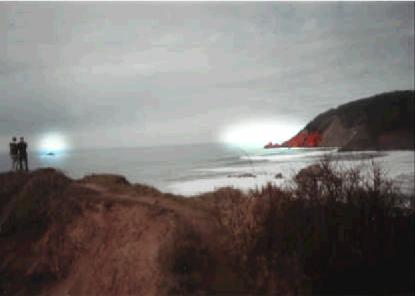
(A sign at the stop reads "Rockwork Historic Site.") At this stop, we observe a large igneous intrusion (according to the trip handout, 320 meters thick), composed of microgabbro and basalt. Some of the local microgabbro has been cut into blocks roughly the shape of quadrangular prisms, and these blocks have been lain end to end to make a low fence at approximately knee-level. Radiometric dating of the intrusion (using thorium, potassium, argon in the rock) puts it at about 14.4 ± 0.4 million years old.
Mueller and Mueller explain the formation of Neahkanie Mountain this way:
Neahkahnie Mountain is a huge sill of Grande Ronde Basalt 1,150 feet thick. Because this is greater than the usual thickness of this flow in the Columbia River Plateau, the lava probably ponded here in a marsh-filled depression or a coastal inlet and sank deeply into these coastal sediments. The mass of lava was later raised to its present elevation and tilted gently northeast with the general uplift of the Coast Range. (262-3)
The photo below shows the blocks composed of microgabbro.

We observe the Nahalem-area spit, which has redirected the flow of the river; there are houses built out on the spit, which indicates its relative age and stability. The gentle shape of the ocean trough provides an excellent opportunity to observe wave formation. The photo below shows the spit and the ocean trough that borders it. Notice the regular inflow of wave-swells from the ocean.

Behind us (as we face the ocean) is a steep cliff into which Highway 101 is cut. There are several features preventing or controlling erosion on the cliff-face here. One is a "netting" on the cliff face to redirect falling rocks downward instead of allowing their parabolic motion to carry them onto cars or the road. There are also metal plates attached to the cliff face by bolts drilled into the rock.
Depart 10:45.
11:00. On bus, en route to Cape Meares. The bus passes the mouth of the Nahalem River, which we had seen from stop 23/iii-2.
11:05. On bus, en route to Cape Meares. We enter the town of Rockaway Beach, which is so close to sea level (some houses appear to the eye to be below sea level) that it is a continuous tsunami hazard zone.
11:08. On bus, en route to Cape Meares. We pass under a bridge that serves as a convenient reference point to call the "south end" of the gradually fading town of Rockaway Beach.
11:12. On bus, en route to Cape Meares. While on the bus, we hear about the town of Bay Ocean, which was built on a spit in this area and had a "nautitorium." The spit on which this town was built eroded within several years of its construction.
11:50. Stop 24/iii-3. Cape Meares. Lunch stop.
We came to the edge of an enormous sink
rimmed by a circle of great broken boulders.
-Dante Alighieri, Inferno xi.1-2 (tr. John Ciardi)
 I watched Louis cook Maruchan Instant Lunch, then wandered down to the lighthouse. This lighthouse, though beautiful, is no longer in use; a much more portable device sitting slightly to its north has replaced it. Mueller and Mueller say that the old lighthouse was in use from 1890 to 1963. (264) Fist astronomy suggests that the old lighthouse, pictured below, is about 36 feet high.
There are also some substantially sized basalt sea-stacks in the ocean. I hiked back up to the parking lot and saw an amazingly vertical cliff, very high, pictured below. This cliff has several distinct layers of basalt and is topped by sandstone. Some of the basalt shows column-like features, although these are not the regular columns we saw at Skinner Butte. Mueller and Mueller explain that this cliff was formed when basalt flows from the general area of the Oregon-Washington-Idaho border intruded into coastal-area sediments beneath the surface of the ocean. (Mueller and Mueller 264)

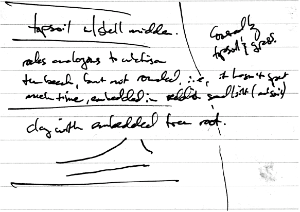
 I wandered through the parking lot to the Octopus Tree, pictured to the right, a huge, ancient Sitka spruce. Because of the high winds on the coast and the partial shelter provided by its location, the spruce developed six "candelabra" branches instead of a single trunk. Each of these branches is at least 12 feet around; the base of the tree has a circumference of about 50 feet.
Depart 12:35.
2:00. On bus, en route to Beverly Beach. We cross the 45th parallel, heading southward.
2:30. On bus, en route to Beverly Beach. We pass an old volcanic crater on the bus. The crater exhibits a regular fan of columnar basalt, much like the basalt at stop 4/i-2.
2:35. Stop 25/iii-6. Beverly Beach.
He with grave looks demanded, for what cause,
Reviving obsolete Idolatry,
I like a Runic Priest, in characters
Of formidable size, had chiseled out
Some uncouth name upon the native rock.
-William Wordsworth, "To Joanna" (part of the "Poems on the Naming of Places" sequence)

We cluster around a tree stump (pictured above) that is surrounded by a wooden fence to prevent visitors from getting too close and is introduced by a sign that reads "Ancient Stump/ Back to the dawn of the Bronze Age!" This stump was originally a root mass that supported a spruce tree. The tree was buried during a subsidence event of some sort, until winter storms exposed it again in 1998 and washed it into Spencer Creek in 1999. Our esteemed professor explains that there are remains of an ancient forest buried in the sand here; we cannot see this forest because it is near high tide. The fenced-in stump will have to do.

We walked out onto the beach to see a westward-tilted, Miocene-era sandstone shelf just east of the water line. Someone named "Jill" (or perhaps someone who was romantically interested in someone with that name) had taken some trouble in carving her name into the rock, as shown in the photo above. This sandstone shelf is part of the Astoria formation, which Orr and Orr describe as "[by] far the most widely distributed, best known marine Miocene unit in the State." (108) Parts of it erode easily, which causes problems for the Oregon Department of Transportation. (Highway 101 runs along the lip of the shelf in places.) The edge of the highway and the cliff itself can be seen in the photo below. In one place on the beach, a section of topsoil had slid twenty or thirty feet down the side of the cliff, keeping its structural integrity and vegetative cover while doing so.
 The sandstone ranges in hardness from extremely hard (I initially mistook it for basalt) to very soft (I easily pulled sheets off the sandstone in some places using only my hands). This sandstone shelf also contains an amazingly large number of fossils. The sandstone was thick with remains of departed sea creatures in some places. I collected a fossil shaped like a thin cigarette butt and a small piece of sandstone with numerous shells embedded in it.
The Roadside Geology of Oregon reiterates Orr and Orr's previous theme on the change of climate in Oregon and how the fossil record provides evidence for it:
The Astoria mudstones contain fossils of animals much more tropical in their affinities than any that lived along the Oregon Coast either before or after Miocene time, the period between about 11 and 25 million years ago. The fossils suggest that the climate was much warmer then and the tropical laterite soils on top of the lava flows repeat the message. (78)
The last part of this stop was the part of the sandstone known, because of the rounded cracks that appear on the surface of this part of the stone, as Turtle Rock. They provide the rock with the appearance of a turtle's shell. These cracks are formed because of differing rates of erosion across the rock's surface. The photo below depicts the rock's surface.

There are also black sands here, as at some of the previous stops in the area.
Depart 3:25. After much debate, we decide to watch the on-bus movie Road Trip.
4:25. On bus, en route to Coos Bay. We pass the location of the Cape Creek slide mentioned and discussed in such detail in my report on the Yardang field trip.
5:10. On bus, en route to Coos Bay. Road Trip ends.
5:45. Stop 26. North Bend. I jump off the bus at the intersection of Virginia & MacPherson and walk home. End of trip.
References
Alt, David D., and Donald W. Hyndman. Roadside Geology of Oregon. Missoula, Montana: Mountain Press, 1984.
Alt, David D., and Donald W. Hyndman. Roadside Geology of Washington. Missoula, Montana: Mountain Press, 1978.
"The End of the Chapter — A Scene on a North Pacific Beach: All that's left of the Peter Iredale." Photograph. Brodie Collection, La Trobe Picture Collection, State Library of Victoria. [1907?] Online. Internet. 8 March 2004. Available http://www.statelibrary.vic.gov.au/brodie/0/0/1/doc/bs001497.shtml.
Friends of Astoria Column. "Oregon Coast: Astoria Column." Online. Internet. 8 March 2004. Available http://www.oregoncoast.com/Astorcol/Astorcol.htm. Approx. 2 pp.
Friends of Old Fort Stevens. "Fort Stevens State Park." Online. Internet. 8 March 2004. Available http://www.visitftstevens.com/history.htm. Approx. 1 p.
"Ilmenite." Webster's Universal College Dictionary. 1997.
Maben, Scott. "In the gas business, waste not, want some." Register-Guard [Eugene]. 17 Feb. 2004: D1+.
MacTarnahan's Brewing Co. "Awards." Online. Internet. 8 March 2004. Available http://www.portlandbrew.com/brews_awards.html. Approx. 3 pp.
Mueller, Marge, and Ted Mueller. Fire, Faults & Floods: A Road & Trail Guide Exploring the Origins of the Columbia River Basin. Moscow, Idaho: University of Idaho Press, 1997.
Orr, William N., and Elizabeth L. Orr. Handbook of Oregon Plant and Animal Fossils. Eugene: University of Oregon, 1981.
"Peter Iredale." Online. Internet. Available http://www.iredale.de/maritime/peter.htm. Approx. 2 pp.
Sandström, Fredrik. "Peter Iredale." Online. Internet. 8 March 2004. Available http://www.infa.abo.fi/~frerik/sships/217.html. Approx. 1 p.
Space for this page provided by
![]()
Get your own free home page.
