
Geology Field Trip Report
The Dunes (Hunt for the Yardang)
Patrick Mooney
G 145 * 01
Trip date: 24 January 2004
Report due date: 24 February 2004
Introduction: Trip Overview and General Considerations
The Southwestern geology field trip on January 24, 2004, was entitled "The Dunes: Hunt for the Yardang." In fact, this title describes only the second half of the field trip: The first half of the field trip, during the time of approximately 8:00 a.m. to 12:00 noon, had little to do with observing any dune directly. We spent that time either north of the dune sheet, or travelling northward through the dune sheet without stopping. Although there are thematic and pedagogical links between the pre-noon and post-noon sections of the trip, it seems profitable to discuss the two sections separately.
The boundary between the two sections of the trip occurred temporally at noon and spatially at stop 4b on the trip itinerary, which is a viewpoint 1.4 miles south of Sea Lion caves on Highway 101. From this viewpoint, it is possible to see the meeting of the northern edge of the dune sheet that lies to the south of that point with the southern edge of the basalt shelf that lies to the north of that point. Therefore, although stop 4b at the viewpoint south of Sea Lion Caves lasted only five minutes, it represents a spatial, temporal, and thematic meeting point for the two halves of the trip. Pedagogically, this stop serves to reinforce the transition from one set of thematic elements (that set with which we were concerned on the first half of the trip) to a second set (that with which we were concerned during the second half).
We spent the first half of the trip, from 8 a.m. to noon, travelling north until we reached the northernmost stop on our itinerary, Smelt Sands beach, at 10:10 a.m. (Although there was a "mystery first stop" at Darlingtonia Gardens before 10:10, this was a value-added or bonus stop not directly related to the thematic content of the first segment of the trip.) The primary focus of this first half of the trip was on the basalt formations that underlie this area: We saw several surface manifestations of this underlying basalt formation, including a basalt shelf at Smelt Sands Beach, several sea-stacks composed of basalt at Heceta Head, and a series of basalt intrusions at Strawberry Hill. The primary source for the basalt in this area is "many local vents in the Cape Perpetua-Heceta head area," which formed "low shield-like accumulations composed largely of subaerial basalt flows 4 to 8 meters thick. [...] [The] basalts were initially erupted on a shallow shelf." (Snavely et al. 42) Basalt is the most common rock type in Oregon. (Alt and Hyndman 9)
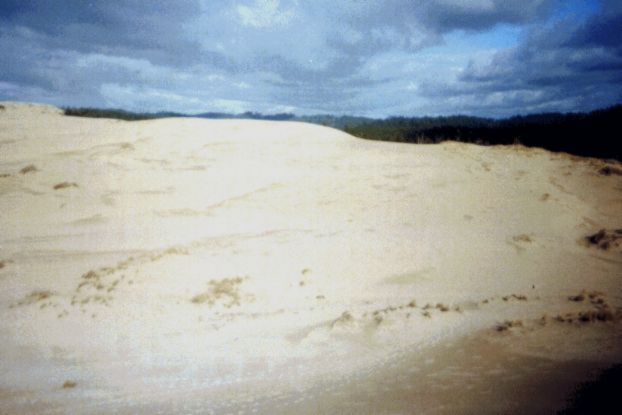
The second half of the trip focused on the coastal dune sheet. The area with which we were concerned on this field trip extends from just north of the North Bend Bridge to the south end of the Siuslaw River. The dune sheet represents an extremely dynamic ecosystem. This dune ecosystem provides a striking visual contrast to the forested and mountainous ecosystem that surrounds it in this part of the state. The dune ecosystem also changes readily under the influence of varying climatic conditions from one season to another. An increase or decrease in the amount of rain on the sand and seasonal changes in the strength and direction of wind provoke dramatic changes in the dune-area topography. An example of this change will be seen in the write-up of stop seven on the trip itinerary, a location I also visited during the "Geology of the Oregon Coast" field trip in August. The ecological composition of areas currently part of the dune ecosystem is also highly susceptible to variations in biological composition. These variations occur as dunes are stabilized by plants capable of growing on them, and larger forms of plant life succeed as the beachgrass stabilizes the dunes and begins to convert the sand into soil. This occurs through the addition of organic matter to the topmost layer of sand and through breakdown, via action of the grass's roots, of individual grains of sand into smaller fragments.
The photo below shows European beachgrass stabilizing dunes at our Eel Creek stop.

Ultimately, a sandy area can be converted into a forested hillside if the sandy area is somehow insulated from the addition of further amounts of sand, and long-term changes in topography (such as those caused by erosion, tectonic subsidence, or the formation of new rocks, i.e. through the cooling of intrusive new lava flows) or ocean level (such as changes associated with the beginnings and ends of ice ages) can provoke changes in the boundaries of areas that do and do not receive new sand from the coastal boundary. The photo below shows a stabilized forest area further out in the Eel Creek stop:

Detailed Trip Report: First Part
8 a.m. We departed SWOCC.
9:15 a.m. "Mystery First Stop": Darlingtonia Wayside. We stopped north of Florence at Darlingtonia Wayside (identified on a sign as "Darlingtonia Gardens") to see a grove of Darlingtonia Californica. This wayside is the only Oregon State Park land that is intended to protect a single plant species. The plant preserved here is also known as the cobra lily (or California pitcher plant), the only representative of the pitcher plant family in Oregon and a member of the American pitcher plant family, Sarraceniaceae. It is a carnivorous plant. These plants typically grow in acidic, nutrient-poor soil, such as bogs and wet meadows, so it thrives in areas where there is little else that is adapted to compete with it. (Kloster) The population we saw was thick and looked well suited to its environment, as it appeared to be thriving.
Darlingtonia traps insects to produce nitrogen by luring the insects into pitcher-shaped hollows formed in its leaves. These pitchers range in size from 0.4 inches to 39 inches. (Species: Darlingtonia 3) Once inside the chamber formed by its leaves, they become confused and slip to the bottom of the hollow, where they are trapped and drown. Bacterial action then breaks down the insect, and the cobra lily absorbs the released nutrients. This behavior (if one can speak of plant "behavior") is an adaptive strategy for dealing with a nutrient-poor soil. (Lang 1) In the bogs in which these plants grow, the nitrogen-poor soil to which the plant is adapted is particularly sandy. This sand is covered with a thin layer of organic material and mud. In this particular location, the high preponderance of sand in the soil is likely due to the site's close proximity to the beach. The Darlingtonia wayside lies in the mouth of the Siuslaw River, just off of Highway 101 near Florence, an area where Highway 101 follows the beach closely towards the northern edge of the dune sheet. In fact, Darlingtonia can develop directly on the wet sand of coastal deflation plains. Their growth can begin adding organic material to the soil and lead to an ecological succession, which may eventually result in a forested area. Darlingtonia normally only remains dominant in areas where no other species are well adapted to compete with it. It often spreads to a new area devastated by fire by colonizing the new area through the spread of rhizomes from an existing population. (Species: Darlingtonia 5-6) The fact that the soil here is still sandy may indicate that this boggy ecosystem represents a comparatively recent intrusion of plant life into a formerly sandy area.
The picture below shows a section of the Darlingtonia garden.

We departed at 9:30.
9:40 a.m. En route to Smelt Sands. The bus passes the remainder of the slide that closed highway 101 for several months a few years ago. This slide, which became known as the Cape Creek slide in the coastal press, occurred on 18 December 1999, covering Highway 101 with a vast amount of mud. It closed the highway for four months and caused significant economic damage to small tourist towns north of the slide location on Highway 101, as it prevented tourist traffic from reaching these towns. The slide forced those traveling between Yachats and Florence to take a three-hour detour through Corvallis and Elmira. ("Coastal Repair"; "Experts") Estimates of the amount of mud that covered the road range from 4000 truckloads ("Coastal Repair") to 7000 truckloads ("Weekend Slide"). Some residents of the area contended at the time that clear-cutting above the slide area contributed to the slide by removing living tree roots, which absorb water running through the soil. The removal of living tree roots by clearcutting, then, resulted in a heavier, more waterlogged soil in the area of the slide. (Browning and Gallob)
Strong metal netting and some spray-on concrete, according to the on-bus lecture, has since fixed this slide. More specifically, the Oregon Department of Transportation solved the problems causing the slide by installing a 400-foot retaining wall, a 16-foot-high steel mesh curtain, and a system of drainage pipes. The total cost to repair the highway and remove the remnants of the slide was approximately $2 million. ("Coastal Repair") Although there have been smaller mudslides on the same site since then, nothing has come near to the magnitude of the series of slides that began on 18 December 1999. ("Cape Cove")
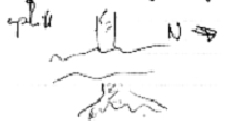
10:10 a.m. Stop 1: Smelt Sands Beach. This beach lies in the town of Yachats, which lies on a Pleistocene-era terrace cut into the Yachats basalt sequence. (Snavely et al. 64) The beach is covered with ugly, smooth brown rocks that are roughly the size of softballs. These ugly brown rocks are molded together by compacted, wet beach sand that is not yet, however, lithified into sandstone. The sand here is extremely coarse; grains that were identified include shell pieces, quartz, agates, basalt, and serpentine. The base rock formation is basalt, weathered and pressurized. There is also a Pleistocene terrace, formed during an ice age, when sea level was lower. It has since been lifted to its present level -- above the present sea level. The fact that a large amount of the sand here is composed of the same rock as the base rock formation seems to indicate that a great deal of the rock that is broken down by erosion is returned to the beach in the form of sand.
The photo below shows the basalt visible at this stop and the Pleistocene terrace.

The location of this stop is just south of the beginning of the Yaquina formation. There is an interesting basalt flow here with rounded pieces. This basalt underlies the Pleistocene terrace. The basalt here is 36 to 40 million years old; the Pleistocene terrace deposit is (by definition) 10,000 to 1.8 million years old -- the question is, what happened in between? Hyndman and Alt refuse to answer this question, pointing out that either the sea level could have dropped or the land could have risen due to tectonic activity during this time. "It is difficult to be sure along such an active coastline where uplift of the land is perfectly possible," they write. The entire town of Yachats is built on this old-beach terrace. (89-90)
Much of Yachats, according to the informative lecture at the site, is in the zone likely to be hit by a tsunami, should another Cascadia subduction event occur. Much of what is not in the tsunami zone is built on a steep hill, and therefore likely to be damaged by the earthquake that would cause the tsunami. Peterson et al. refer to a 1996 study by Doyle, which estimates that a 75 cm subsidence Cascadia Subduction Zone event would result in 50 meters of beach retreat at Siletz Bay. (Peterson 2) Siletz Bay is somewhat farther north than the location we visited in Yachats, but these figures still indicate, in general terms, the magnitude of the problem: We saw a large number of houses, hotels, shops, and other buildings within 50 meters of the water in Yachats. Assuming that the expected subsidence in Yachats is more or less the same as the expected subsidence in Siletz Bay helps to provide a mental image of what the view of Yachats from above would look like after the Subduction Zone event: Fifty meters of ocean encroachment would wipe out a large portion of this small town.
It is difficult or impossible to find specific estimates of damage to the small town of Yachats, of course, but the more broadly based study of Wang and Clark provides a more specific idea of the damage that a Cascadia Subduction Zone tectonic event might cause. Wang and Clark used a computer modeling system to estimate the damage caused by an 8.5-magnitude tectonic event due to a rupture in the Cascadia fault. They provide estimates for every county in Oregon; in this context, the estimates for Lincoln County (of which Yachats is part) and Lane County (which has its northern border about four miles south of Yachats) are particularly relevant. Wang and Clark estimate that an 8.5-magnitude Cascadia Subduction Zone event would cause 7 deaths, 358 injuries, and $624 million in economic damage in Lincoln County, and would leave only 51% of bridges, 26% of fire stations, and 22% of police stations operational the day after the quake. (44) They estimate that this same tectonic event would cause 19 deaths, 1036 injuries, and $1.6 billion in economic damage in Lane County, and would leave 49% of fire stations, 42% of police stations, and 76% of bridges operational the day after the quake. (43) (Admittedly, it is difficult to compare the figures for these two counties meaningfully because Lane County has a larger population and economic base -- it includes the Eugene-Springfield metropolitan area -- and because it occupies a much larger land area, much of which lies inland. Still, these figures give a general sense of the magnitude of the problem.) Wang and Clark emphasize several times that "Tsunami damages are not included in the estimates for this earthquake, and would seriously increase losses for coastal counties." (3) It is easy to see how this study, despite its dire predictions, seriously underestimates the potential damage to a small coastal community like Yachats.
Rare plant life in this area includes golden-eyed grasses and bog anemones.
We departed at 10:30 a.m.
10:45 a.m. Stop 2: Strawberry Hill. We observed a series of large igneous (basalt) intrusions running parallel to each other. A particularly noticeable formation runs down the length of the hill near the path leading down to the beach. Its surface seems to be composed of remarkably regular, brick-like shapes. A small arm of the ocean cuts through this longest and most prominent basalt flow, which is the one on which we concentrated:
These flows are dikes, not sills.
The photos below show the texture of this igneous intrusion and the way that it can be seen rising above the ridge from above.


The sand here is fine-grained and, for the most part, uniformly tan. It is dark, partly because it is wet.
There are piles of shell midden lying around this area. "Shell midden" is the discarded remains of shellfish caught and shelled by native people in the area. Native peoples removed the shells from the shellfish on the coast before transporting them back inland because the transportation of inedible shells over a substantial walking distance would be a waste of effort. Because those removing the shells from the shellfish remained stationary while doing so, the shells accumulated in a heap, and some of these shell heaps have been preserved as shell midden. These remains may provide clues to diet and, because fragments of tools may be found in it, ways of life for native peoples. These shells were deposited by native people shelling shellfish and not, for instance, by the uplifting of a fossil bed. Because it is organic and of comparatively recent origin, the shell midden can be dated with radiocarbon dating techniques.
We departed at 11:05 a.m.
11:25 a.m. Stop 3: Heceta Churn ("Devil's Elbow"). We hiked down to the beach from the bus. The churn was formed by erosion of a fault in flows of the Yachats Basalt. The dikes in this area are formed of basalt and the silica-rich basaltic rock andesite. (Snavely et al. 64) There are extremely large basalt formations in the ocean, sea-stacks that used to be attached to the mainland but were separated when the softer rock around the stacks eroded. The sand visible at this stop is tan in color with flecks of black. This black sand may be composed of basalt, but Beaulieu and Hughes explain that black sands in Coos and Douglas counties often contain deposits of heavy minerals, including iron, chromium, and small deposits of gold, titanium, zirconium, platinum, and garnet. (53)
A small igneous intrusion, substantially smaller than that at Strawberry Hill, runs down into the water. Unlike the dikes at Strawberry Hill, this basalt formation has larger vesicles and a different texture, indicating that this basalt formation cooled faster on the outside and slower on the inside than the examples seen at Strawberry Hill. This different manner of cooling gave the gas a chance to escape. Interestingly enough, this formation is a basalt formation that cuts through an earlier basalt formation.


The photos above show these basalt sea-stacks in the ocean at Devil's elbow.
We departed at 11:50 a.m. and passed the site of the slide, mentioned above, at 11:55.
Detailed Trip Report: Interlude
12:00 noon. Stop 4b. We stopped at the north end of dune sheet for a quick photo opportunity. The photo shows the transition between the drop-off of the basalt formation's cliffs and the coastal dune sheet. This stop, despite its short length, is a focal point showcasing the transition between the thematic concerns of the two halves of today's trip, as discussed in the introduction to this paper. The photo below shows the transition from the dune basalt base to the dune sheet, as we saw it from stop 4b.

From this point onwards, our primary consideration during the field trip was the coastal dune sheet. Alt and Hyndman say that this is "probably the most spectacular tract of coastal sand dunes in the country." (91) Baldwin et al. describe the area of the dune sheet in this way:
The coastal plain is as much as 4 miles in width and consists of low marine terraces [...]. North of Coos Bay the terraces are largely covered by sand dunes; the smaller dunes are active, but the older dunes are stabilized by protective vegetation. [...] [In] low coastal areas, shifting dunes border small bodies of water which represent trapped runoff or the intersection of local topography with the water table. (5)
Baldwin et al. also give the age of the dune sheet formation as Holocene. Komar and Schlicker say that the general direction of sand drift in the winter is northward, under the influence of winter storms from the southwest, and southward during the summer. The net transport of sand already on the dune sheet therefore zero over the course of a year. (169)
The sand of the dune sheet overlays older marine deposits of Pleistocene age, and older fine-grained Tertiary deposits -- specifically, the Eocene-age Coaledo siltstone-sandstone-mudstone formation and the Bastendorff shale -- underlie these Pleistocene deposits. The dune-sand layer itself is up to 200 feet thick and averages about 100 feet in thickness. Its elevation ranges from about 180 feet below sea level to a few feet above sea level. (Jones 5) This part of Oregon has lain above the water level for about 50 million years, or since Eocene time. (Alt and Hyndman, 15)
Dunes themselves are accumulations of sand grains that collect in piles under the force of winds. Sand -- small pieces of eroded rock -- is cast onto the shore from the ocean by waves and pushed inland by wind. The single largest local source of sand on beaches is the Umpqua River. (Beaulieu and Hughes 99) Individual sand grains are lifted by wind and propelled along until they are stopped by something. Because the grains are too heavy to stay airborne for long, the wind can only "bounce" them along the surface, a process that repeats until they run into something soft, off of which they cannot bounce. If the something soft that stops the grains is itself a sand ripple, sand begins to accumulate in that spot. If this accumulation continues, the ripple will grow into a dune. Sand will begin to collect even due to minor variations in the level of the underlying sand, such as irregularities in the underlying ground topography, so sand under the influence of wind has a tendency to form ripples. These ripples lie transverse to the direction of prevailing winds, and the period of distance between them is related to the strength of the wind. Sand ripples can travel without disturbing the grains of sand that they travel over. If conditions are right, dunes form. (Guadalupe Restoration Project 1-2; Alt and Hyndman 93)
This second part of the trip gave me a chance to observe changes since the field trip I took this summer in several locations. The sketch below is of the dune we climbed at Eel Creek both this summer and on the current field trip and was drawn on the field trip this summer; the photo is a photo taken of that same dune on this field trip. Note the figures at the top, which provide scale.

We departed stop 4b at 12:05 p.m.
Detailed Trip Report: Second Part
12:15 p.m. En route to Honeyman State Park. Passed Florence's Fred Meyer store, which was formerly the site of the last (when moving northwards along Highway 101) open dune. Part of the dune remains behind the department store and is visible from the highway.
12:25 p.m. En route to Honeyman State Park. We enter the Oregon Dunes National Recreation Area.
12:30 p.m. Stop 5: Jessie M. Honeyman State Park. This was our lunch stop. I ate a sandwich, then walked out to a dock in the lake and gazed across the lake at the dunes. There is a magnificent view of the dunes here. I also took some photos that didn't turn out, a phenomenon that will be explained in the section describing the sixth stop. Alt and Hyndman point out that blowing sand and migrating active sand dunes are overtaking and burying forest and moving northeast into Cleawox Lake at a rate of about 17 feet per year. (92)
We departed for the Oregon Dunes Overlook at 12:50 p.m.
1:05 p.m. Stop 6: Oregon Dunes Overlook. This was the stop in which we most directly focused on the yardang hunt, as promised in the trip's introductory handout. Throughout the day we had been titillated by oblique remarks about yardangs, though no one on the bus seemed to know exactly what sort of animal, vegetable, or mineral a "yardang" might be. After being briefly cautioned, in an orientation session, about how to approach the yardang, we set off in search of it. Trusty cigarette in hand, sunglasses on head, I followed our esteemed professor and several other student travelers over sandy hill and dale out on the surface of the dunes on what he termed the "March to Forever." It took fifteen minutes to reach our destination: We finally climbed the face of a long dune, atop which the yardang sat. The sand composing this dune and in this area in general is a darker tan than the Heceta sand sample. It is very fine and contains flecks of basalt.
I discovered later that one of the mystical powers of the yardang, like its close phonetic relative the yeti, is that it can keep a camera from functioning properly. None of my photos from this or subsequent stops turned out, although there was plenty of film in the camera and the camera was loaded properly. The yardang seems to have obliterated all of the photos I took from our lunch stop onwards by causing the camera to jam mysteriously and expose the same slip of film over and over. When I returned late in the day to try to re-photograph the yardang and have a late picnic lunch with my girlfriend several days later, the yardang arranged for heavy cloud cover that prevented even 800-speed film exposed at a slow shutter speed from producing well-exposed prints. Instead, the film produced only dark, low-contrast prints on that occasion. However, the yardang failed to take into account the power of Adobe Photoshop, which allowed me to produce photos that display useful features of the yardang despite its sly instincts.
A "yardang," it turns out, is a type of geological formation. It is defined in the Infoplease dictionary as "a keel-shaped crest or ridge [of sand, in this case], formed by the action of the wind, usually parallel to the prevailing wind direction." (Infoplease) The Etymological Dictionary of Geology explains the term's origin this way: "Turkish 'yardang' = ablative of 'yar' = steep bank, precipice; also, Turkish-Mongol 'yardang' = separate, dividing." Yardangs can be observed in deserts around the world and are prominent on Mars.
Yardangs are formed when newer dunes form on top of an already-extant dune. If changing winds erode the older underlying dune, the younger dunes will migrate, and the original dune will begin to erode. This erosion continues until the only part that left of the original underlying dune is its core, a structure that often does not erode because it is aerodynamic. This remaining aerodynamic core is called a yardang. (Guadalupe Restoration 4)
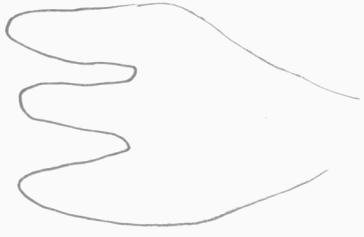
The yardang we saw was unusual: It branched out into three parts, like the tines on a fork, which were connected by a single hump on the back. From above, it must have looked like a three-toed foot:
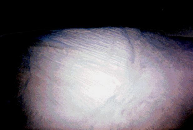
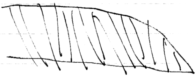
Seen from the side, the yardang demonstrates clearly that it is composed of layers of sand, which are piled on the previous layers. Each layer of sand composing the yardang's "toes" sits more or less askew from true vertical atop the sand, leaning slightly backwards on the previous layer. The photo below shows the top of one of the yardang's toes and demonstrates this feature of yardang construction. Ridges indicate the tops of different layers of sand:
The back of the yardang, i.e. its "heel," on the other hand, seems to be composed of vertical layers, as demonstrated in this photo:

This is a quick sketch showing the layering of sand in one of the yardang's "toes."
In Oregon, yardangs only form in the winter, because moisture is required to hold the sand together. This particular yardang sits atop a large dune. Dunes in this area migrate northward in the winter, unless plant life stabilizes them.
There was a great deal of beachgrass throughout the area we were able to see at this stop. There are also isolated areas that beachgrass has stabilized enough so that larger plants have been able to sprout. Some of these stabilized dune areas have turned into small forests.
The return trip to our orientation point took fifteen minutes. Our bus departed at 1:50 p.m.
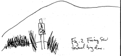
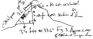
2:25 p.m. Stop 7: Eel Creek Campground. We hiked a half mile from the bus to the top of the same dune we visited this summer on the "Geology of the Oregon Coast" field trip. As before, I measured the size of the dune we hiked using Randy Sloper's "fist astronomy" method. This involves using right-triangle trigonometry in combination with estimates of the length of one side of a triangle and an estimate of one angle of the triangle to calculate rough estimates for other parts of the triangle. The estimate for the length of a side is calculated by counting paces (I know that the average length of one of my paces is about 26 inches). The estimate for the angle is arrived at by holding my first at arm's length and counting how many times I need to hold it end-to-end to equal the perceived length or height of whatever I am trying to measure. (I know that my fist held outstretched at arm's length subtends approximately 9.6 degrees of my field of vision). In August, I estimated the height of the dune at about 86 feet; this time, I estimated the height of the dune at just over 68 feet. I estimated the angle of elevation that the dune's face forms above horizontal at approximately 33.6 degrees in August; this time, the dune's estimated angle of elevation was about 26.7 degrees. In August, I estimated the length of the dune's face at 156 feet; this time, I estimated that the length of the dune's face at about 152 feet.
In fact, these measurements may not be as easily comparable as the above paragraph suggests. Although I used the same general methodology for measuring the dune in both cases, it is possible that small variations in measurement could have larger effects in the result of the calculation. There is an additional problem with the measurement of the length of the face of the dune: The standard measure of my pace was calibrated on a horizontal surface. Because the surface of the dune is not horizontal, it is likely that the measurement of 26 inches = 1 pace is somewhat inaccurate in this case. Moreover, because the angle of elevation of the dune's surface is different in both cases, it is possible that the length of a pace on the dune's surface in August is not equal to the length of a similar pace during this visit. I have tried to compensate for both problems by taking several measures. First, I have tried to compensate for the non-horizontal nature of the dune's face by taking the "real" number of paces required to traverse the dune's face to be the arithmetic average of the number of steps I counted ascending and the number of paces I counted descending the dune's surface. I also estimate, somewhat arbitrarily, that my measurements of angles are accurate to within one-half of a finger's width, or about 10% of my fist's width. Finally, I estimate that lengths based on paces could vary by as much as 15% of the reported length, even after the average of the two measurements has been taken. Taking these calculations into account and converting the measurements to the metric system results in the following table:
| Length of the dune's face | Angle of elevation | Height of the dune | Half-width of the dune | |
| August | 40m to 55m | 30.2 degrees to 37 degrees | 20m to 33m | 32m to 47m |
| January | 39m to 53m | 24.2 degrees to 29.6 degrees | 16m to 26m | 34m to 48m |
Table one, above, is a classic example of the way in which two comparatively small uncertainties in measurement produce a fairly large uncertainty in the final result. However, it is also clear, in a general way, that the shape of the dune has changed in the last five months: The face that was measured twice is now less sharply angled, and the dune is shorter. There are two factors to which this change in shape can be attributed. One of these is the seasonal change in the direction and intensity of the prevailing winds. (Table 1 measures the half-width of the dune because this change in the direction of the prevailing winds makes it unlikely that a long dune would be symmetrical. By "half-width," I mean the length that extends from the base point from which the angle of elevation was measured to a point at an equal horizontal level and directly below the high point on the triangle used in the calculations -- not half of the horizontal width of the dune.) The other factor is the increase in rain during the winter months, which would be expected to compact the sand composing the dune and, thus, decrease its height.
This diagram, from this summer's report, illustrates how the calculations involved were made:
From the top of the dune, we looked back downward toward a small, flat plain a few hundred yards northward of point where the forested trail exits onto the sandy dune sheet. This plain exhibits ridged patterns of light, or dry, sand on top of dark, or wet, sand. The wet sand represents the water table in the area. This is the minimum level to which the elevation of sand can be diminished in a particular spot, and explains the flatness of the surface on which the dry sand lies. The dry sand lies above the water table in a series of sinuous ridges, each of which has the potential to grow up into a dune. In fact, when I revisited the area on February 8, these sand ridges had gained substantially in size, as shown in the photo below.
The water table mentioned above is interesting in its own right. According to Jones, pumps in the dune aquifer in this area supply a substantial amount of water to the Coos Bay-North Bend area. Jones gives the amount of water, as of 1987, both as 5 million gallons per day (several times, e.g. on page 1) and as 4.63 million gallons per day (57). Jones used computer-modeling techniques based on available data describing rainfall, local topography, and the conditions of the hydrological conductivity of the dune to estimate how much water is available for human use from the dune aquifer. Jones's model estimates that 10 million Mgal/d could be pumped without substantially increased risk of depleting the aquifer or causing seawater to intrude, and that 17 Mgal/d could most likely be pumped without causing either of these conditions to occur. However, Jones cautions throughout the report, "the risk of intrusion associated with pumping this quantity over time is uncertain." (1) More specifically, Jones explains the danger of over-pumping this way:
"If pumping increases beyond 17 Mgal/d, upconing of seawater or the regional freshwater-seawater interface could rise to levels where seawater or the regional fresh-water seawater interface could rise to levels where seawater would flow into wells." (51)
The water table expresses itself visually as lakes that are visible on the dune surface. These lakes are continuous with the water table. The photo below shows a lake on surface of the dune sheet.

There was also a herd of yardangs along the top of this dune. These yardangs were individual "humps" and lacked the distinctive three-toed appearance of the yardang we observed at the Eel Creek stop. These yardangs lacked the larger yardang's power of clouding film (perhaps they were younger), and several photos of them were suitable for use without digital enhancement, as shown in the photos below.


The sand here is similar to the sand at the Dunes Overlook, but finer and with fewer flecks of black in it.
We departed at 3:00 p.m.
3:20 p.m. Stop 8: Horsfall Beach. We hiked over a short sand ridge to reach the beach, which is noticeably narrower than it was when we visited this summer. This observation fits well with Komar and Schlicker's general observation that beach sand in Oregon is washed out into bars during the winter, and then washed back up onto the beach itself during the summer. (171)
We were instructed to perform an experiment to determine the offshore drift speed of the water. In order to do this, we measured off a distance of 100 feet and tossed an orange into the ocean at a point nearly parallel with the north end of our tape measure. Theoretically, then, we should have been able to determine the speed of offshore drift by dividing the distance the orange traveled -- a known constant that we determined in setting up the experiment -- by the amount of time it took to travel that distance, which we would measure in the course of the experiment.
However, several factors presented an easy measurement of the speed of offshore drift. One was the strong wind blowing onto the shore, which blew almost exactly perpendicular to the shoreline. The direction that the wind pushed the waves, which was identical, presented another problem. Because of these factors, the orange returned quickly to the shore the first five times we performed the experiment, drifting 12 to 20 feet southward each time. Finally, on the sixth attempt, the orange stayed out at sea. On this occasion, it drifted south 100 feet in three minutes, twenty-five seconds, for an approximate average velocity of 14.87 cm/s. During the first five attempts, the orange drifted back to the shoreline in 77, 74, 76, 69, and 78 seconds, respectively.
When we performed this same experiment in the same manner during the field trip this summer, we obtained different results. On that occasion, I calculated a rate of offshore drift of 11.79 cm/s northward (the prevailing current changes direction on a seasonal basis). However, the measurements are probably not directly comparable because of the complexity of the system of currents in this location -- one measurement of velocity at a certain distance out at sea may not adequately represent the overall motion of the water at the beach.
According to Beaulieu and Hughes, offshore currents in this area average about 0.25 knots (approximately 12.86 cm/s), but can reach 3 to 4 knots (about 150 cm/sec to 200 cm/s) when tides, wind, and currents cooperate to push the water in the same direction. (7) The figures we obtained in the single measurement we were able to make, then, are typical of the area.
We departed at 3:55 p.m.
4:00 p.m. Our bus passes out of the Oregon Dunes National Recreation Area on the way back to school.
4:15 p.m. Arrive at SWOCC.
References
Alt, David D. and Donald W. Hyndman. Roadside Geology of Oregon. Missoula, Montana: Mountain Press, 1978.
Baldwin, Ewart M., John D. Beaulieu, Len Ramp, Jerry Gray, Vernon C. Newton, Jr., and Ralph S. Mason. Geology and Mineral Resources of Coos County, Oregon. State of Oregon. Department of Geology and Mineral Industries. Bulletin 80. Portland: Department of Geology and Mineral Resources, 1973.
Beaulieu, John D. and Paul W. Hughes. Environmental Geology of Western Coos and Douglas Counties, Oregon. State of Oregon. Dept. of Geology and Mineral Industries. Bulletin 87. Portland: Dept. of Geology and Mineral Industries, 1975.
Browning, Melissa, and Joel Gallob. "Clearcut's Role Questioned in Highway Failure." Newport News-Times 29 December 1999, Internet archive. Approx. 2 pp. Available http://www.newportnewstimes.com/1999/nt_news1229/general/nt_news-04.html.
"Coastal Repair Stays Put Despite Bad Weather." World [Coos Bay, Oregon] 10 December 2001, Internet archive. Approx. 1 p. Available http://www.theworldlink.com/articles/2001/12/10/news03.txt.
"Experts Say Highway Could Slide Once More." World [Coos Bay, Oregon] 8 January 2001, Internet archive. Approx 2 pp. Available http://www.theworldlink.com/articles/2001/01/08/vitals06.txt.
Guadalupe Restoration Project-Dunes Center Docent Manual. Online. Internet. 27 January 2004. Available http://www.guaddunes.com/duneManual.html.
Jones, M. A. Ground-Water Availability from a Dune-Sand Aquifer Near Coos Bay and North Bend, Oregon. U.S. Department of the Interior. U.S. Geological Survey. Open-File Report 90-563. Portland, 1992.
Kloster, Tom. "Darlingtonia Wayside." Online. Internet. 13 February 2004. Approx. 1 p. Available http://www.splintercat.org/DarlingtoniaWayside/DarlingtoniaPages/DarlingtoniaMainPage.html.
Komar, Paul D., and Herb Schlicker. "Beach Processes and Erosion Problems on the Oregon Coast." Geologic Field Trips in Western Oregon and Southwestern Washington. Eds. Oles, Keith F., J. Granville Johnson, Alan R. Niem, and Wendy A. Niem. State of Oregon. Department of Geology and Mineral Industries. Published for the Cordilleran Section Meeting of the Geological Society of America. Portland: Department of Geology and Mineral Industries, 1980. 169-173.
Lang, Frank. "Darlingtonia." Online. Internet. 13 January 2004. Approx. 2 pp. Available http://www.fs.fed.us/r6/siskiyou/langnote.htm. Reprinted from Jefferson Monthly, May 1996.
Peterson, Curt D., Elson T. Barnett, Greg G. Briggs, Gary A. Carver, John J. Clague, and Mark E. Darienzo. Estimates of Coastal Subsidence from Great Earthquakes in the Cascadia Subduction Zone, Vancouver Island, B.C., Washington, Oregon, and Northernmost California. State of Oregon. Dept. of Geology and Mineral Industries. Open-File Report O-97-5. Portland: Department of Geology and Mineral Industries, 1997.
Snavely, P. D., Jr., N. S. MacLeod, H. C. Wagner, and D. L. Lander. "Geology of the West-Central Part of the Oregon Coast Range." Geologic Field Trips in Western Oregon and Southwestern Washington. Eds. Oles, Keith F., J. Granville Johnson, Alan R. Niem, and Wendy A. Niem. State of Oregon. Department of Geology and Mineral Industries. Published for the Cordilleran Section Meeting of the Geological Society of America. Portland: Department of Geology and Mineral Industries, 1980. 39-76.
"Species: Darlingtonia Californica." Online. Internet. 13 February 2004. Approx. 10 pp. Available http://www.fs.fed.us/database/feis/plants/forb/darcal/all.html.
Wang, Yumei, and J. L. Clark. Earthquake Damage in Oregon: Preliminary Estimates of Future Earthquake Losses. State of Oregon. Dept. of Geology and Mineral Industries. Special Report 29. 1999.
"Weekend Slide South of Yachats Keeps Highway 101 Closed." Newport News-Times 22 December 1999, Internet Archive. Approx. 1 p. Available http://www.newportnewstimes.com/1999/nt_news1222/general/nt_news-22.html.
"Yardang" in The Etymological Dictionary of Geology. Online. Internet. Available http://www.georoots.org/term_page.asp?terminit=y. 27 January 2004.
"Yardang" in Infoplease.com Dictionary. Online. Internet. 27 January 2004. Available http://www.infoplease.com/ipd/A0743437.html.
Space for this page provided by
![]()
Get your own free home page.
