
Wadi Mistal
Oman
| General | Travel
| Visas | Locations | Maps,
books | Geology | Snapshots
Bandar Khayran | Jabal
Akhdar | Masirah | Mountains
| Musandam | Salalah | Seifa
| Wadi Mistal | Wahibah
Spring blossom
The farmers of Al
Jabal al Akhdar cultivate a wide variety of fruit trees including almonds,
apricots, figs, dates and pomegranate, high up in the foothills of Al
Hajar al Gharbi.
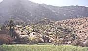
The agricultural terraces of Wakan village, sited at the source of Wadi Mistal, boast an unforgettable display of white and pink blossom in early Spring. We went in mid-February.
 |
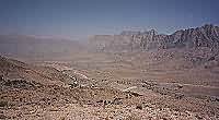
The turning to Wadi Mistal lies 16 km beyond Nakhl on the road to Rustaq. The mountains of Al Hajar al Gharbi, comprising shelf and deep ocean sediments strongly tilted to the north, loom on the horizon. |
| The road cuts through chocolate coloured mantle ophiolites which have been thrust over the sediments further south. I find the colour comforting! |
 |
 |
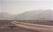
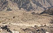
Just six km from the main road, Wadi Mistal cuts through a narrow gorge to reveal the Ghubrah bowl beyond. Softer, rocks have been eroded away to form a basin of older rocks rimmed by high peaks. |
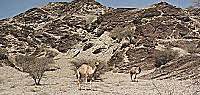
| Stray camels roam the countryside. These two are posing in front of an outcrop of diamictite reckoned to be over 600 Ma. According to Hanna, this is a poorly-sorted glacial deposit showing large pebbles embedded in a fine-grained mudstone matrix, but I'm more inclined to the view of the BRGM geologists that these rocks have a volcano-sedimentary origin. |
 |
The well-graded track forges through the bowl to the source of Wadi Mistal some 40 km from the main road. The bowl takes its name from the village of Ghubrah which lies near the middle, the only settlement other than occasional hamlets of 2 to 3 houses.
 |
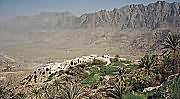
At the far end of the bowl, the road climbs steeply to the agricultural villages. It is too hot and water is too scarce to cultivate crops in the Ghubrah bowl itself. This is Hajar village. |
| The better-off villagers have Yemeni-style houses with two or three storeys rather than the single-storey houses favoured by the Omanis on the coast. These houses are at Wakan village. |
 |
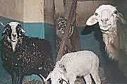 |
The villagers keep sheep and goats in their houses too. These animals had blue eyes, which might mean that they had special value. |
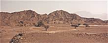
| This was what we had come to see - the fruit trees of Wakan village in blossom. The flat land in the foreground is used to grow vegetables and forage crops. The trees are terraced on the hillside behind. |
 |
Although so out of the way, the villages are probably quite prosperous. The variety of fruits and vegetables that could be grown here would fetch a valuable income in markets on the plain and coast.
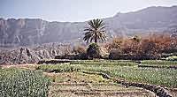 |
The village falaj distributes water amongst the small vegetable plots on the flatter terraces. Bunds confine the water to encourage infiltration. |
| The village and terraces cling to the hillside. Agriculture is small-scale since water supplies are not plentiful. Yet water is the secret of survival for the village. |
 |
 |
The village falaj (water channel) is the community's life-line. The water is gathered from springs higher up the mountain side. Within the village, the water is used for domestic supply and washing before it is distributed to the small fields. The girls of the village would not permit their photographs to be taken which is why all you see here are washed pots. |
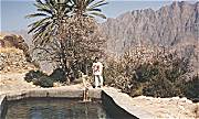
| Above the village, the water flow is more plentiful. Supplies to other areas are distributed from this holding tank or are controlled by blocking and opening networks of channels according to a prescribed time schedule. |
 |
 |
It's probably not clear to see here, but these are abandoned agricultural terraces. Diversification of employment has taken people off the land, so it's not necessary to cultivate the land as extensively as in the past. Notably, several truck-loads of men passed us who seemed to be returning to the villages to spend their weekends. |
Although I couldn't make it, there is a small mosque right at the end of the wadi where the springs emerge from the mountain-side. It looks over the entire Ghubrah bowl to the north.
You need a four-wheel drive vehicle for the final haul up to the village from the plain. Park below the village and walk through the fields to the falaj winding its way up the hill. The walk to the mosque is not for the unfit, and can take up to an hour or more.
The children appear to be friendly. They will ask for baksheesh, or sweets. It's great to be friendly back. Just keep the car locked while you're away from it. The older girls grabbed my guide book and pored over the English with great interest. Libraries and books are not a feature of village life, although a large school and clinic lie at the foot of the road up to the villages.
Back to Oman for more Off-road pages.
Home | Contact me | Resume | George in Egypt | Oman | Cyprus | Thailand