Journal
| About Downunda | Trail
Facts | Hiking the Trail
State Guide | Elevation
Map | Fun Facts
Gear | Photos | Guestbook
| Mailing
List | Home
|
|
Journal
| About Downunda | Trail
Facts | Hiking the Trail |
|
1st September 2002 From:
Wadleigh Stream Lean-to 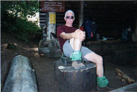 It was another great day - sunny skies and the temperatures in the high
70's. However, last night the temps were in the 40's and you could
certainly feel it this morning.
It was another great day - sunny skies and the temperatures in the high
70's. However, last night the temps were in the 40's and you could
certainly feel it this morning.
I hiked through to the Rainbow Stream Lean-to (pictured), which was eight miles. I decided to have a leisurely lunch there, as it is one of the more picturesque shelter locations. It was featured in a 1987 issue of National Geographic. 'Lotto' was there when I arrived but pushed on shortly after as he had big miles to do today. 'Scarecrow' arrived later as did a Southbounder, so we three had a nice chat in the sun for about an hour. I then pushed on - my goal was to set up camp at the Rainbow Spring Campsite on Rainbow Lake, however, when I got there I was disappointed to find that the lake could not be seen from the tent area. A Southbound hiker told me there were some good sites right on the lake about three miles further on. I found a good spot right at the end of the lake just before the AT leaves it. This lake is about five miles long by 1/2 mile wide and has the clearest water of any of the ponds or lakes I've seen. It's absolutely quiet here; it's just on dusk and there is no wind. Hopefully the loons are about and will give me a few calls before I go to sleep. Tomorrow I was planning to have an early day and just do seven miles to Abol Bridge and stay at the private campground. However, the weather report suggests showers on Wednesday (the day I was planning to summit Katahdin - today is Sunday), so I may make an 18 mile push tomorrow (trail conditions permitting) and get to the Katahdin Stream Campground by tomorrow night, one day earlier than planned. The campground at Abol Bridge has a store, so I'm looking forward to a few treats in the morning. That's it for today. Goodnight all.
|
|