Great Photographs of the Sahyadris


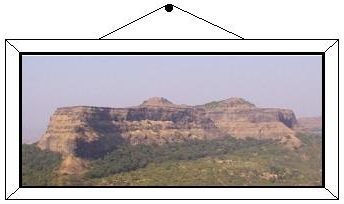
Scattered across the millions of websites on the Internet are some truly spectacular photographs of the Sahyadris. The following is a selection of such photos that will leave you spell-bound. From climbing the rock walls of Chanderi to the vast expanse of Harishchandragad, these photos convey the thrill of actually being there.


When you click on any of the links below, a new window will appear containing the photo you selected. Keep in mind that it may take some time for the photo to appear, depending on your Internet connection speed and the size of the photo image. To get back to this page, simply close the window containing the photograph, or minimize it.

Since the search process for great photographs is a continuous one, the chances are that the next time you visit this website, there will be more photographs awaiting your exploration. This site will expand considerably from the current selection shown below.

Please note that these great photos are mostly at external websites. You can contact the website owners directly for any information related to these photos.


Alang

(Click here for GPS Coordinates)

  • Want to know why Alang is out of bounds to most hikers (that includes me)... check out the route in this photo!


  • Another reason why Alang is not for the faint-hearted. Check out the drop just inches from the hiking 'route'.


  • Alang is one of the peaks for which technical climbing (climbing with ropes, etc) is required. This photo of Alang provides a good idea of what is involved in scaling this peak.


  • The full stretch of Alang can be seen here, showing the sheer cliffs that are so characteristic of this peak.


  • Ancient ruins on the top of Alang.


  • Chanderi

    (Click here for GPS Coordinates)

  • A grand view of the entire peak from the start of the climb.


  • The sheer rock wall of Chanderi, as one approaches the base of the wall from the northern ridge.


  • The final stages of the climb to the summit is highly exposed and dangerous. This photo shows one of the earlier stages of this climb.


  • This photo is one of my all-time favourites. This is from the summit of Chanderi and shows the entire 600 foot high rock wall that was just climbed.


  • At the edge of eternity - the summit of Chanderi, with Tavli, Haji Malang, Badlapur hill and Mahasmal in the background.


  • Haji Malang

    (Click here for GPS Coordinates)

  • The way to the summit of Haji Malang is graphically captured in this set of photos


  • Harishchandragad

    (Click here for GPS Coordinates)

  • A panaromic view of the Konkan Kada, a sheer 1 kilometer drop at the western edge of Harishchandragad. To really appreciate the sense of scale in this photo, what you are seeing is just the top 1000 feet of this vertical drop!


  • Fantastic pictures of a descent down the Konkan Kada! How do these guys have the courage to pull this one off?


  • The large water tank near the main temple complex on Harishchandragad. Use your imagination to turn the clock back a thousand years and picture the ancient rishis performing their rituals at this very spot.


  • One of the most impressive photos of the Konkan Kada that I have seen so far, this shows a vertical drop of about 2000 feet, with more to go! This photo certainly gives everyone a sense of appreciation of the achievement of the few who have climbed the Konkan Kada.


  • Another great view of the Konkan Kada, looking North. It is hard to imagine the scale on this photograph until one realizes that the peaks in the background are a sheer 4000 feet of rock rising straight out of the plains.


  • The main temple structure on Harishchandragad, which is well over a thousand years old. One can only imagine the effort in creating this masterpiece out of nothing but hand tools and manual labour.


  • The ancient Shiv-ling inside a cave near the main temple complex on Harishchandragad. Most unfortunately, there exist individuals who can damage invaluable ancient relics such as these.


  • Jivdhan

    (Click here for GPS Coordinates)

  • The natural strength and the massive size of this fort is seen in this photograph of the western wall.


  • The huge pinnacle on the south of the fort is one of the main characteristics of this fort. With a sheer ascent of over 600 feet, it is accessible only to the most hardened rock climbers.


  • A remarkable view of the pinnacle mentioned above, this photograph shows the entire pinnacle as seen from the summit of Jivdhan. There is nothing to give the sense of scale, so one has to create a reference: what you are seeing of the pinnacle in this photograph is taller than any of the skyscrapers in Mumbai!


  • Kulang

    (Click here for GPS Coordinates)

  • Cant climb Kulang? No problem ... this series of photos takes you on a virtual tour!


  • This photo taken from the base shows the enormous strength of the natural fortifications of Kulang.


  • This is a very interesting photo because it is taken from the summit of Kulang and points in exactly the opposite direction as the photo shown above. Using the two photos, you can get a very good idea of the terrain around this part of Kulang.


  • Rock-cut steps on the exposed face of Kulang.


  • Another photo showing the exposed route to the summit.


  • Rock-cut tanks on the narrow summit of Kulang. Note the sheer drops on either side.


  • Ancient fortifications on the summit of Kulang. The origin of these fortifications is a mystery.


  • Madangad

    (Click here for GPS Coordinates)

  • Cant climb Madangad? No problem ... this series of photos takes you on a virtual tour!


  • An awesome photo of Madangad, showing the full elevation along with the 'hole' near the summit.


  • Another great photo of Madangad, also showing the ridge with Kulang.


  • A fantastic view of Madangad from Alang, with Kulang in the background.


  • Mangi-Tungi

    (Click here for GPS Coordinates)

  • A brief description of the significance of Mangi-Tungi


  • An impressive view from the base of the climb.


  • The route to the summit.


  • Overhang above route.


  • An unobstructed view of the route from near the summit.


  • The summit pinnacle.


  • The last steps before reaching the summit plateau.


  • One of the many caves to be found on the plateau.


  • Prabal

    (Click here for GPS Coordinates)

  • A great view of Prabal illuminated by the morning sky. This is from the point where most hikes begin. Prabal can even be viewed from Mumbai on clear days.


  • This photo dramatically shows the huge cliffs that are seen all around the Prabal plateau.


  • The Prabal pinnacle and the Prabal plateau, as seen from a small village on a secondary plateau.


  • A small temple in splendid isolation and surrounded by thick forests on the top of Prabal.


  • One of the many fantastic views from the large plateau of Prabal. This one shows fortifications of unknown origin on a protruding spur


  • This impressive photograph of the Prabal pinnacle has been taken from the northern edge of the Prabal plateau. This pinnacle is a landmark observable from the western edge of Matheran. It can even be seen from Mumbai in clear weather.


  • Tavli

    (Click here for GPS Coordinates)

  • The pinnacles of Tavli, as seen on the way up. It is hard to imagine that on the very top there is a permanent settlement that is not difficult to reach.


  • A view of the pinnacles from the saddle connecting Tavli with Badlapur Hill.


  • This photo is taken a short distance from where the previous photo was shot. The view is in the opposite direction. You can see the saddle connecting Tavli with Badlapur Hill. Look carefully and you can even see Chanderi in the background.


  • A great view of the Malang-Matheran range while approaching the summit of Tavli. Chanderi is clearly visible and the vast plateau behind it is Matheran.


  • A grand view from the summit of Tavli. Note the flat top and the permanent settlements. It is hard to imagine this is on top of the huge pinnacles that you saw in the previous photos. Haji Malang is seen in the background in the right. Badlapur Hill is seen on the left and to the immediate right of it is the Ganesh pinnacle.

    If you get a chance to stand on this very spot after dark, you will get the MOST IMPRESSIVE night-view ever, with Mumbai to your west, the Mumbai harbour lights, Mumbai airport, Kalyan, Ulhasnagar, Ambernath and all the towns to Karjat. Each of these appears as a large collection of shimmering lights surrounded by darkness. No words can truly describe the night view from here.


  • This tiny enclosed compound on the top of Tavli is on the edge of an abyss of a thousand feet on one side.


  • Telbaila

    (Click here for GPS Coordinates)

  • A view of this very interesting rock formation as seen from the base of the climb. The climbing route has been superposed on it.


  • Tungi

    (Click here for GPS Coordinates)

  • A very impressive picture of Tungi, with an almost perfect reflection in the still waters of Pavna lake.


  • Visapur

    (Click here for GPS Coordinates)

  • The huge fort of Visapur, as viewed from Lohgad, is shown here from end to end, along with the southern climbing route.


  • Do you know of similar interesting photographs on the Internet? If so, please e-mail me the web links of the photos by clicking here.

    Also, since all the above links are external, they may get outdated without notice. If you find that any of the links shown above is not functional, I would appreciate you letting me know by clicking here.