HOLIDAY GEOLOGY AROUND KILLARNEY, COUNTY KERRY. Ian Clarke
For our holiday this year we decided to go to south-west Ireland in search of spectacular scenery, peace, quiet and the occasional Guinness. Family holidays and geological field days are not often compatible, and this was no exception. However, there were plenty of opportunities to appreciate the geological setting of this lovely region. The Killarney area has rocks of Devonian to Upper Carboniferous age. The nearby Dingle Peninsula goes back even further, with Ordovician and Silurian strata. There is also a great deal of Quaternary cover, with much evidence of glacial action.
Killarney area
Close to Killarney itself, in the grounds of Muckross House, the path along the north shore of Muckross Lake gives access to an almost complete section of the uppermost Devonian Red Beds through to limestones of Waulsortian Facies of Dinantian (Lower Carboniferous) age. This section shows a transition from terrestrial deposition in alluvial fans in a desert environment to marine sedimentation.Travelling south-west from Killarney on the N71, the road passes through many exposures of the Glenfesk Chloritic Sandstone Formation. This consists of green-coloured, mostly medium-grained sandstone, conglomerate and pebbly sandstone, together with green and purple siltstone. Features that can be seen in some road cuttings are ripples and mud cracks. I even found some fossil (pyritised) plant fragments. The other highlights of this spectacular route are the views of McGillycuddy’s Reeks and the chance to see some of the effects of glaciation on the landscape. From the excellent viewpoints at and near Ladies View and Moll’s Gap (if you aren’t dragged into the craft shops), there are excellent views of the Gap of Dunloe—a 200m deep breach cut through the mountain ridge by ice. On a smaller scale, there are many fine examples of roches moutonées and other exposed surfaces that have been striated and polished by ice.
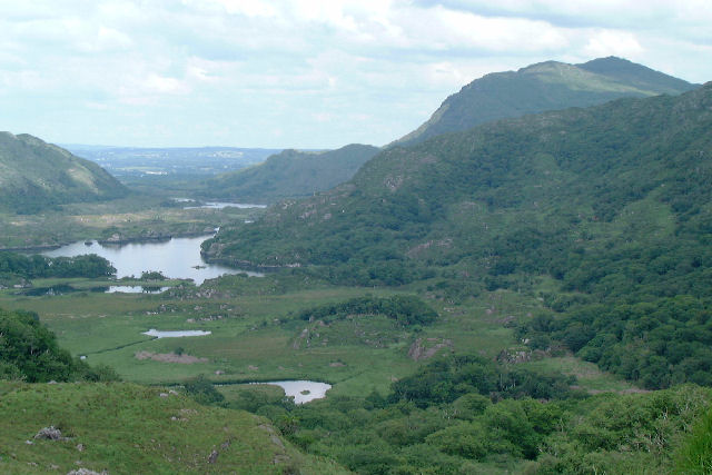 Gap of Dunloe
The Dingle Peninsula
The Dingle Peninsula is a popular destination for holidaymakers, with magnificent scenery, beautiful beaches, and many ancient archaeological sites. Equipped with the Rough Guide to Ireland and the trail guide to the geology of the Dingle in “The making of Ireland: landscapes in geology” by Michael Williams and David Harper, we went in search of the delights of this beautiful peninsula.The geological highlights were: Slea Head – Late Silurian to Early Devonian pebbly sandstones with cross-stratification, that formed as dunes or bars in a large river. Slea Head also has dramatic seascapes and views of the Blasket Islands to the west. Dunquin – yellow-brown Silurian rocks (Dunquin Group, deposited in a marine environment), which give way to red Devonian rocks of the Dingle Group, deposited above sea level in rivers. These rocks show a regression when sea level fell in the late Silurian. Clogher Head – tuffs from large Silurian volcanoes, which marked the southern edge of the Iapetus Ocean about 420 million years ago. Ferriter’s Cove – the rocks of the Ferriter’s Cove Formation are some of the oldest Silurian rocks on the peninsula. They are red and brown siltstones, thin sandstones, and some tuffs, Fossils, including trilobites can be found. The rocks were laid down in a marine environment near a volcanic centre. More details of these localities and several others are given in the trail guide.
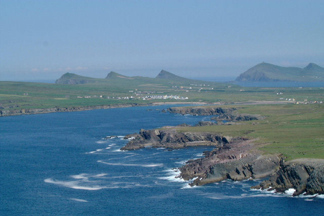 Coast around Ferriter's
Cove
Coast around Ferriter's
Cove
The unexpected
One of the delights of being on holiday is finding the unexpected. Here are three that I particularly enjoyed:The village of Sneem on the Ring of Kerry
route is a neat and tidy, picturesque village, with its houses washed in
different colours (reputedly so that drunken villagers can find their way
home!). It also has an embryonic geopark project complete with visitor centre,
showing the area’s geological structure.
( www.kerrygeopark.com for more details). The N71 road between Kenmare
and Glengarriff - a series of tunnels cut through Devonian sandstones, with
magnificent views of Bantry Bay.
Bantry House - crammed with art treasures, superb gardens, this early 19th Century house has a wonderful setting overlooking Bantry Bay. There is also a very interesting exhibition about the attempted French invasion of Ireland in 1796. But something I found thrilling was that the paving slabs at the back of the house were full of trace fossils (Nereites?).
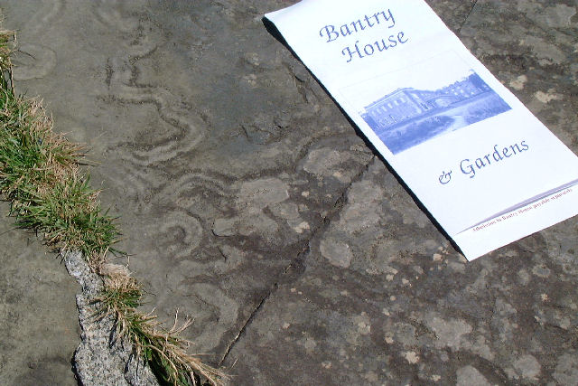 Trace
fossils at Bantry House
Trace
fossils at Bantry House
I can thoroughly recommend this part of Ireland for a holiday. Unfortunately, I never did get to grips with the tectonic setting and stucture, though ---thrusts, faults, anticlines and synclines associated with the Variscan orogeny. Perhaps next time……….
Further reading:
The Rough Guide to Ireland. 2003. 7th ed Rough Guides 1 84353059 7
The making of Ireland: landscapes in geology. Williams, M & Harper, D. 2003. IMMEL Publishing. 1 89816266 2
Geology of Dingle Bay. Pracht, M. 1996. Geological Survey of Ireland. 1 89970203 2
Geology of Kerry-Cork. Pracht, M. 1997. Geological Survey of Ireland. 1 89970210 5
The last 2 items are available from the OUGS East Midlands Branch library.
Or if you wish to purchase your own copy :- http://www.gsi.ie/prodserv/shop-fra.htm
All photos © Ian Clarke