The dispute over the dividing line between Pennsylvania and its neighboring colonies to the south lasted centuries and absorbed the energies of many generations.
Delaware. A circular line separating the lower counties of Delaware from Penn's province had always been part of William Penn's land patent from King Charles II that was granted in 1681. However, because the area was sparsely settled, nothing much was done about it until 1701. It is a popular notion that Mason and Dixon surveyed the line, but in truth, two other surveyors named Isaac Taylor from Chester County and Thomas Pierson from New Castle County surveyed the boundry in accordance with the King's patent[1].
Maryland. William Calvert, Lord Baltimore, had received a patent from King Charles I in 1632 and settled along the Chesepeake Bay in Maryland. Long before William Penn arrived, he had demanded from the Dutch along the Delaware River all the lands south of the 40th parallel on the west side of the river, which included the present-day city of Philadelphia [see map]. When William Penn arrived 50 years later, the land between these two provinces fell into dispute. In 1750, a British court declared the border to be lattitude 39 degrees 43 minutes north. It helped, but disagreements continued. To settle the dispute, England's Royal Astronomer sent Charles Mason and Jeremiah Dixon in 1767 to survey the border[2].
Virginia. Pennsylvania and Virginia could not agree on their border along the frontier of both states in what is now present-day Greene County, Pennsylvania[3]. It was not until 1781 when both states operated their own courts that the issues were finally resolved.
The Early "Super Counties" of Pennsylvania
When William Penn landed in 1682, he divided his colony into three "super counties," to be governed as traditional English shires.
Chester County. Formed out of Upland County, Chester County was centered around the city of Upland (renamed Chester). The county already contained the most thriving communities, and Penn originally considered making Chester the capital of his new colony. However, border disputes with Lord Calvert who had settled Maryland left his southern boundry in doubt, and he was reluctant to have his capital so close to, or possibly within, the borders of an opposing colony. Yet, Chester County would continue to grow and became the first melting pot of the New World.
Philadelphia County. Instead, of naming the already-thriving city of Chester the capitol of his new colony, Penn built one up-river at a struggling community situated between the Delaware and Schuykill Rivers. He named the fledgling capitol Philadelphia, meaning "brotherly love," and called the surrounding countryside Philadelphia County[4].
Bucks County. Finally, the remainder of Penn's land north of his new capitol became Bucks County, named for Buckinghamshire, England where the Penn family had lived for generations. Most of the original European settlers in the county were Quakers, and their clergymen were educated in a log cabin at Neshaminy. William Penn would build his colonial home of Pennsbury Manor in Bucks County[5].
Where Did Lancaster County Come From?
William Penn's "Holy Experiment" was such a success that his colony quickly grew, particularly in western Chester county. Settlers began moving into the backwoods of the county beyond Octoraro Creek and into the Susquehanna River Valley, mixing with Swiss-German Anabaptists and French Huguenots who had sought religious santuary, unruly Scotch-Irish and Welsh immigrants who scorned the tame English settlements along the Delaware, Native Americans who had become resentful of European encroachments, and habitual lawbreakers who found easy escape in the untamed western hills and valleys. Before long, the growing population demanded law enforcement and representation in governing bodies to civilize the newly-formed townships they had carved out of the Pennsylvania wilderness[6].
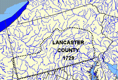
By the early 1700s, Chester County had become so populated that it was necessary to split off a separate county. On 19 May 1729, Lancaster County was organized out of Chester County and named for Lancastershire, England. Its boundry was to run from the northern branch of the Octoraro Creek north to the Schuylkill River, which would then serve as its eastern boundary. The southern border of Pennsylvania -- still being disputed by Lord Calvert -- would be the county's southern border as well. The remainder of the county would extend south of the West Branch of the Susquehanna River as far west as the original charter -- to the present-day border with Ohio [ see map].
By the end of 1729, the settled portions of the county had been organized into eighteen townships with names chosen to represent every nationality of the governed[7].
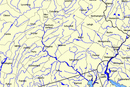
But as new setlements were formed and the population continued to grow, other counties were carved from Lancaster County. The first was York County in 1749. Adams County soon followed, and with the creation of Cumberland County in 1750, Lancaster County no longer extended to the Ohio border. With the creation of Berks County in 1752, Northumberland County in 1772, Dauphin County in 1785, and Lebanon County in 1813, Lancaster County was reduced to its present size. Today, only the eastern border of Lancaster County that it shares with Chester County along Octoraro Creek remains of the old boundry lines [ see map].
|
|
Footnotes
1Taylor and Pierson ran a line 12 miles north from "... the end of the horse dyke next to the town of New Castle to a white oak marked with twelve notches standing on the west side of Brandywine Creek ..." from which they drew a circular radius. However, this spot can no longer be located. Over the years, the horse dyke became absorbed by the settlement, the oak tree disappearered, and a stone marking the point was lost to "money-diggers." So the exact location was soon lost to myth and tradition. No survey of the circular line has ever been made since 1701 and no one can say with any degree of scientific certainty where the original line exists that today separates New Castle County, Delaware, and Delaware County, Pennsylvania.
2During the Missouri Compromise debates in 1820, the Mason Dixon line was referred to as the dividing line between free and border states. It is a popular, albeit erroneous, conclusion that this is the reason the line was surveyed. However, its sole intention at the time was to resolve the bitter border dispute between rival Calvert and Penn families of Maryland and Pennsylvania long before the subject of slavery had ever become an issue.
3Greene County, Pennsylvania no longer borders Virginia, but at one time it did. At the start of the Civil War, all the lands in the present-day state of West Virginia were part of Virginia, and so bordered Pennsylvania. During the war, the western mountian counties of Virginia felt they had little in common with the landed gentry and large plantation owners of eastern Virginia. They disagreed with the vote to seceed, and so formed their own state during the course of the war. In 1862, West Virginia was granted statehood by a U.S. Congress without a quarom of members due to the walk-out of the southern legislators, an action that many in the South felt was unconstitutional.
4The city and county of Philadelphia are today one and the same. Philadelphia became a city in 1701, after which a portion of the county was split off and re-incorporated as Montgomery County. Then in 1854, what remained of the old county of Philadelphia merged with the city. Philadelphia was economically the strongest city in Colonial America, but was surpassed by New York City in the early 1800s. However, it continued strong national leadership in manufacturing, textiles, shoes, shipbuilding, transportation, and machinery throughout the 19th century. While Quaker leadership had helped shape pre-Revolutionary Philadelphia, it soon gave way as the numbers and the wealth of the Society of Friends dwindled. Philadelphia today has been called "the City of Communities" and the "American Paris." Its downtown entertainment industries, quaint city shops, small dining establishments, extensive cultural activities, health and education facilities, and historical background make it one of the most visited cities in the United States.
5The original county seat of Bucks county was located at Bristol, followed by Newtown. Then in 1812, Doylestown replaced Newtown as the county seat, and was incorporated as a borough in 1838. It was named for William Doyle, a local innkeeper. Originally devoted to farm and dairy, by the time of World War II the county had been subdivided and reincorporated a number of times and was the center for the manufacture of textiles, pottery, tiles, and steel. Today, only 22 percent of the land is devoted to agriculture.
6While William Penn had set up his government based on traditional English concepts of relations among civilized white persons, it would be the backcountry of Chester County that would forge new concepts of complete democratic involvement of all the governed.
7Warwick, Lancaster, Martic, Sadsbury, Salisbury, and Hempfield were English; Donegal, Drumore, Derry, and Leacock were Scotch-Irish; Caernarvon and Lampeter were Welsh; Manheim and Earl (an anglicized form of the Graff name) were German; Conestoga, Peshtank (also Paxtang or Paxton), and Cocalico were Native American; and the last -- Lebanon -- was from the Bible.
|
