HALL OF ANTIQUITIES OF THE SYRIAN COASTLINETell SoukasExcavations of the Danish Mission This archaeological site falls in the plain of Jablah , the widest and richest plain of the eastern coast of the Mediterranean Sea . Tell Soukas which lies directly on the coast , about 6 Km from Jablah looks over this fertile plain . It stands on one of the best natural harbours of the Phoenician Coast . Its height is 24 m. above the sea-level . Its most ancient stratum dates back to the 6th millennium B. C. , and Its top stratum goes back to the Hellenistic Ages . The site was originally Greek Settlement set up by Nebuchadnezzar after the battle of Carchemish and was , later on , destroyed by Cyrrhus . Many pottery shreds from the Hellenistic and Arab Periods have been discovered at this site. In the texts of Ugarit ( Ras-Shamra ) , the city was mentioned as falling between Ugarit and Siano . Is seems that this city of the recent Bronze Age was destroyed completely by the Invading Sea Peoples as is the case with the other cities of the Phoenician Coast. The strata of the Bronze Age, particularly that of the recent Bronze Age, have provided us with patterns of Cypriot Painted pottery, terracotta Mycenaean statues, cylinder seals of the Kissite and Sumerian genre dating back to the 17th century down to the 12th century , and a half of an Egyptian Scarab In the name of Amenophis Ill ( l405 - 1370 B. C. ) . There are also numerous Egyptian Scarabs , Phoenician Seals from the Hyksos Period and some bronze pieces of the Middle Bronze Age.
|
TELL KAZEL ( SIMYRA (Excavations of the Directorate General of Antiquities and Museums The city of Simyra is mentioned in the Bible, in the Tell-el Amarna Tablets, Tiglath-Pilser Ill and also in the other clasics cf the Antiquity . Therefore, it can be gathered from these different source that Simyra was situated in the territory falling to the south of the ancient City of Amrit (Marathus ) by the mouth of Nahr-el-Kabir and to the north of the slopes of the mountains of Lebanon. Some archaeologists have Undertaken a number of researches in the said area in order to determine the actual location of the city. Having explored all the archaeological tells of the area. they came to the conclusion that the tell which bears today the name of Tell Kazel had the best chance of being identified with Simyra. Tell Kazel is situated on the right shore of Nahr-el-Abrach at about 3.5 K.M from its mouth. It is a vast and elevated tell Its height in Proportion to the nearby plain is about 25 m. It is 28 Km. more or less to the south of Tartus. In this connection Strabo says "Simyra was the last of the possessions of Arwad ( Aradus ) to the south " .
From what has been said above, it may be safely assumed that Tell Kazel is possibly standing now on the site of the ancient Simyra. However, the Directorate-General of Antiquities and Museums has actually conducted a number of explorations to verify the stratification of the Tell and to compare its relevant historic data to those of the city under research. There sondages were conducted during the Spring of 1956 until the digging reached the stratum of the recent bronze. Later on. a mission consisting of Maurice Dunan. Adnan Bounni and Nassib Saliby undertook three campaigns of excavations. respectively 1960, 1961 and 1962. These excavations, respectively of the following Ages: The Rornan-Hellenistic. the Iron and the Recent Bronze. It was also proved that the city was flourishing in the Hellenistic and Persian Periods. Like the other sister cities of the Phoenician Coast ( Arwad and Amrit). Simrya disappeared in the Roman Period to give way to the new big cities. The remains of the Assyrian Period and those of the Iron Age which can be seen at Tell Kazel indicate that the city had a certain importance. The layer which is contemporary with the Recent Bronze is deep and it many yield indications in future to at test the identification of this sites the ancient Simyra.
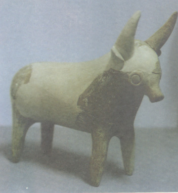
Terracotta rhyton representing a horned bull , its mouth is in the form of a U-trap , standing on its four limbs and ornamented with red intersected lines. L. 14.5 cm. H. 17 cm.
|
AMRIT (MARATHUS(Excavations of the Directorate-General of Antiquities and Museums. Some 7 kilometres to the south of Tartus. opposite the Island of Arwad, lies an ancient city of Marathus. In the reign of Alexander the Great, Marathus was a prosperous city and very famous for its temple. When the mission of Renan the well-known archaeologist. excavated Amrit about the middle of the 19th century, there were the remains of 11 monuments in the city. We still see today, the remains of the temple, the spinning mill, the mound and the Greek Stadium. Amrit is mentioned in the annals of Tiglath-Pilser III and in the accounts of the campaigns of Thothmes III. as forming a northern border to the possessions of Simyra. In 1926, a valuable collection of stone statues and statuettes dating back to the 4th and 3rd centuries B.C., were discovered at a site west of the temple and the mound (the Favissa ). ln 1880. a stone stele representing a god on a lion, carrying a truncheon in his right hand, was also discovered. The stele bears Phoenician inscriptions of the 4th century B.C. Amrit is mentioned in the annals of Thothmes III under the name Kart Amrwta . Etymologically qart means city in Phoenician such as Carthage or Carthago, and is often followed by a diminutive i.e. Amrwta . The name of the city is also mentioned as Marathus during the conquests of Alexander the Great. In this very city, Alexander the Great and Darius, King of Persia, exchanged the messages of their diplomatic negotiations. Tell Amrit ( Marathus ) represents the residential institutions related to the life of the neighbouring temple. In the course of excavations, some antiquities of the Hellenistic and Persian Periods and of the Bronze and Iron Ages, were discovered. We hope that the forthcoming excavations would provide as with more historical data about the life of the people at that Tell in the 2nd and 1st millennia B.C. In actual fact, Tell Amrit may constitute an important link in the study of this area, which is still obscure, and which stretches between the Mediterranean Sea and the Orontes. Amrit had been in close contact with the civilization of the Greek world since the 7th century B.C. In this period, the cities of Phoenician Coast displayed tangible activity, particularly in the domain of commercial exchange all over the Mediterranean. The Greek historians and the Assyrian Chronicles talked about this activity and about the establishment of relations between the emerging country of Greek and the Orient civilizations from which the Greeks borrowed the Oriental thought in the realm of philosophy, religion and alphabet. The Greeks likewise learnt many of the Phoenician industries.
|