CARTOSAT-2A, thirteenth in the Indian Remote Sensing (IRS) satellite series, is an advanced remote sensing satellite capable of providing scene-specific spot imagery. It has now joined the other six IRS (Indian Remote Sensing) satellites which are in service; IRS-1D, OCEANSAT-1. TES, RESOURCESAT-1. CARTOSAT-1 and CARTOSAT-2.
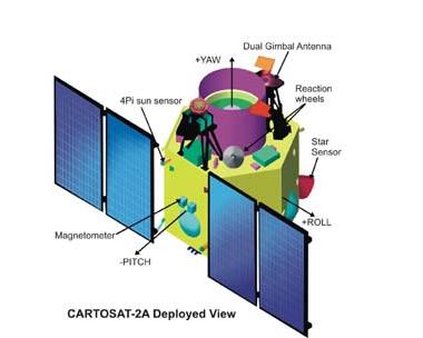
Similar to CARTOSAT-1 but lighter and more sophisticated it is placed in a 635 km Polar Sun Synchronous Orbit with an inclination of 97.94 deg with respect to the equator, the 690 kg highly agile CARTOSAT-2A carries a Panchromatic Camera (PAN) to provide imagery with a spatial resolution of better than one metre and a swath of 9.6 km. The satellite can be steered up to 45 deg along as well as across the track. Data from the satellite can be used for cartographic applications at cadastral level, urban and rural infrastructure development and management, as well as applications in Land Information System (LIS) and Geographical Information System (GIS).[ISRO]