| Didcot to Long Wittenham and Wallingford
From Didcot Parkway station
forecourt turn left along Station Road and
then left again under Cow Lane railway bridge.
The NCN route turns left immediately after the bridge
to follow the paved shared-use path through the Ladygrove
housing estate. The route though Ladygrove is marked with temporary signs
and stickers on the lamp posts. Look out for the 5
symbol.
Shortly after the shops two paved paths meet at a cross-roads: turn left
here, following the direction of the power lines. This path eventually
bears right, leaving Ladygrove via a tunnel under the Perimeter Road. From
the tunnel a new surfaced path leads through the fields, crossing the Appleford
Road, to Long Wittenham. |
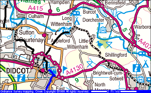 |
| Route 5 enters Long Wittenham
past the Pendon Museum, then passes through
the village which has traffic calming. At the end of the village turn right,
following the lane to Little Wittenham, passing
(or calling at!) the Machine Man inn. From here the route passes through
Little Wittenham then up the hill past Wittenham
Clumps. Stop to see the iron age fort, the nature reserve and the
Poetry Tree. |
Map images produced from the Ordnance Survey Get-a-map
service. Image reproduced with kind permission of Ordnance
Survey and Multi Media Mapping.
 |
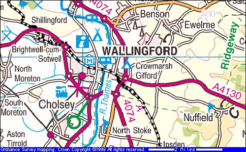
| The route then goes back down the hill to join the road
to Brightwell and Wallingford. Just before the road meets the A4130 look
out for a left hand turn to a path through some trees. This leads to a
crossing point over the main road and then another path into Brightwell.
Follow the road right through Brightwell until it rejoins the A4130 near
the start of the Wallingford bypass. A shared use path is marked around
the arms of the roundabout, then there are cycle lanes along the road into
Wallingford. |
Link to Upton railway path From Cow Lane in Didcot
there is an off-road link to the disused railway line that leads
south from Didcot to Upton (shown in blue on the map above).
Sustrans plans to upgrade this route as an extension to the NCN. Turn
right upon leaving the underpass and follow the path in an easterly direction
though the houses to a pedestrian/cyclist subway under the railway. From
the subway go up to the nearby roundabout, cross Lower Broadway and you
can find the railway path up the embankment. |
| Wallingford to Ipsden
Follow the road through Wallingford, over the historic
Wallingford
Bridge and through Crowmarsh. Prepare
to turn right shortly before the bypass: a short off-road path avoids the
roundabout and brings you onto the bypass opposite the lane to Ipsden.
An improved crossing facility has been constructed here.
The road to Ipsden is fairly quiet and crosses the Ridgeway
at the start of the Chilterns. The road climbs steadily after Ipsden, giving
excellent views across the Vale, and then passes into forest. |
 |
|
Map images produced from the Ordnance Survey Get-a-map
service. Image reproduced with kind permission of Ordnance
Survey and Multi Media Mapping. |
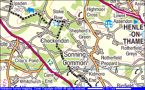
| Ipsden to Stoke Row, Checkendon and Kidmore End
The route follows minor lanes through woodland to Stoke
Row, where you can stop to see the Maharaja's
Well. It then goes back onto forest roads to Checkendon,
passing Sonning Common and Kidmore
End. Look out for sharp bends and sudden turns
on these lanes- not all the Route 5 signposts are clearly visible. They
are also fairly small and easily missed at high speeds! |
 |
|
Map images produced from the Ordnance Survey Get-a-map
service. Image reproduced with kind permission of Ordnance
Survey and Multi Media Mapping. |
| Kidmore End to Reading
Route 5 continues on the road past Tokers
Green, but goes off-road for a short distance over the golf
course near Caversham. Once into Reading the route is back on the
road until the Thames, where it rejoins the riverside path on its way towards
Windsor. Reading station is very close to the route- it is not clear on
the map, but the main station is amongst the roundabouts near the river. |
 |
| Return to Thames Valley Route index |
We hope you enjoy riding the Thames Valley Route. We
plan to develop this web site, including photos and information on things
to see on the way. If you have any suggestions then please contact Marcus
Jones. |