Quarry History There is no doubt that the greatest impact on this area was when the quarrymen came to town!. The site was originally owned and developed by the Farnley Group of Companies, who in January 1970 became incorporated in an amalgamation of associated companies to form Tilling Construction Services Limited now known as Tilcon Limited. Operations commenced on the site in mid-1961 when minerals were extracted and then processed through the nearby Grimbald plant, prior to the erection of a new processing plant in July 1962. Early in 1975, the Knaresborough plant closed down and sand and gravel extracted since that time was transported and processed through the nearby Farnham plant.
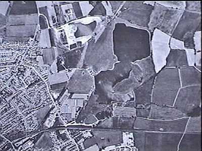
AREA AND TYPE OF DEPOSITS:- 73 ha (180 acres) of fluvio-glacial sand and gravel which was deposited from the Nidderdale ice sheet. The deposit varied from 3m to 9m (10 feet to 30 feet) in depth, of good quality mineral mainly from wet workings. PLANNING REQUIREMENTS:- Early planning permissions called for topsoil to be retained for subsequent respreading over exhausted dry areas or back-filled waste material (the workings were also used as a amenity tip by the local council). The lagooned workings had to be treated as to avoid marshland with no mounds protruding above water level and a clear boundary defined between land and water. Landscaping of the site was a condition of consent KB/868/H dated 23rd September 1971. A scheme was submitted and approved in 1972. RESTORATION:- Restoration, now complete, had been progressive over the years with particular attention being paid to ensuring that the land left was sufficiently above the water table to remain firm and not boggy. Restoration on the site was carried out as early as 1968 forming a feature mound (now known locally as Observation Hill) east of the lake and 3 ha (8 acres) of adjacent agricultural land.
|